Hoser (Viersen)
|
Panties
City of Viersen
Coordinates: 51 ° 14 ′ 45 " N , 6 ° 22 ′ 45" E
|
||
|---|---|---|
| Height : | 55-67 m above sea level NN | |
| Incorporated into: | Viersen | |
| Postal code : | 41747 | |
| Area code : | 02162 | |
|
Location of Hoser in Viersen |
||
Hoser is a district of the North Rhine-Westphalian district town of Viersen . Within the city of Viersen, the village of Hoser is located in the west of the Alt-Viersen district . Unlike the district of Bockert , which is a little further south , Hoser is postally included in the Viersen city center and therefore has the postcode 41747 (and not 41748). Earlier names for the place were Holthusen or Hooser . As far as it has been passed down at all, Hoser has been part of Viersen since the Middle Ages , nothing is known of any kind of communal independence. The situation is similar in ecclesiastical terms: Hoser does not have its own Catholic parish church, but is affiliated with the parish of St. Peter in the neighboring district of Bockert.


economy
Kaiser's Tengelmann
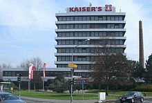
The headquarters of the Kaiser's Tengelmann retail group was located in the Hoser district of Viersen from 1880 until the end of 2009 . As of January 1, 2010, the administration of Kaiser's Tengelmann was relocated to Mülheim an der Ruhr . The lettering "Kaiser's" on the roof of the former administration high-rise has since been removed.
traffic
Road traffic
- Hoser is crossed by the two-lane state road L39 in a north-south direction . To the north of the former Kaiser’s high-rise on the corner of Ernst-Moritz-Arndt-Strasse, this is Lichtenberg Street (in the direction of Viersen city center), and to the south of it is Hardter Strasse , which leads via Bockert to Mönchengladbach-Hardt .
- In a west-east direction, Kreisstraße 18, here as Brasselstraße , connects Hoser with Beberich and Gladbacher Straße (L71).
- A little further north runs parallel to the K18, the Ernst-Moritz-Arndt-Straße , which also leads from the corner of Lichtenberg / Hardter Straße at the former Kaiser’s -Hochhaus to Gladbacher Straße and beyond that to the four-lane L116 ( Kölnische Straße ).
- The closest motorway connection is, a little west of the neighboring district of Bockert, the Mackenstein motorway connection on the A 61 .
Rail transport
There is no rail-based passenger transport in Hoser and there has never been, either as a rail or tram. However, there was a freight track for this until the 1980s. The freight line branched off a little northeast of Hamm from the main railway line running there and passed around the southern edge of the old town of Viersen to Hoser. Here the route ended in the area of the Kaiser’s commercial complex . Remnants of this freight track are still visible next to the Bachstrasse under the railway underpass northeast of Viersen-Hamm. The closest train station to Hoser that is still in operation for passenger traffic is Viersen station . (As of April 2011)
Bus transport
As a district of Viersen, Hoser is part of the tariff area of the Rhine-Ruhr transport association . The Mönchengladbach NVV AG and Viersener Niederrheinwerke serve the district Hoser with three bus lines:
| Type | line | route | Hints |
|---|---|---|---|
| SB 88 | Viersen train station ↔ Viersen, bus terminal. ↔ Hoser, Landwehrstr. ↔ Mackenstein ↔ Schwalmtal ↔ Niederkrüchten ↔ Elmpt ↔ Brüggen |
Schnellbus , NVV AG On the way to Schwalmtal, the bus goes through the neighboring district of Bockert , but doesn't stop there! |
|
| 081 | Bockert ↔ Hoser ↔ Viersen, Gereonsplatz ↔ Viersen, bus station. ↔ Krefelder Str. ↔ Robend ↔ Düpp, Im Wolfhahn | Niederrheinwerke Viersen | |
| 082 | Bockert ↔ Hoser ↔ Viersen, bus station. ↔ Viersen, Gereonsplatz ↔ Viersen, station ↔ Robend ↔ Düpp, Im Wolfhahn |
Niederrheinwerke Viersen , in Hoser the “Eigenheim” stop is also used. |
|
| (As of April 2011) |
Bike trails
The town of Hoser is crossed or touched by several cycle paths , a total of three officially designated cycle paths lead through the area on 2 axes:
- The Irmgardispfad , an inner-city hiking trail for pedestrians and cyclists , leads directly through Hoser . The Irmgardis path leads from the Irmgardiskapelle in the Süchtelner heights on the western outskirts of Alt-Viersen past Hoser and on via Beberich , Ompert and Ummer to Helenabrunn .
- A little outside of Hoser run on a common road:
- The main route of the NiederRheinroute , here especially between Alt-Viersen and Dülken .
- The German Football Route NRW , here especially between the adventure cities of Krefeld and Mönchengladbach .
Association and social life
- St. Petri Rifle Brotherhood of 1753 Viersen-Hoser eV
- Viersen volunteer fire brigade , Hoser fire fighting group
- Carnival Society Hoseria Viersen-Hoser 1950 eV
Attractions
- Inner Landwehr : A little outside of Hoser, remains of the Inner Landwehr of Alt-Viersen have been preserved and are officially designated as a cultural monument.
- Viersener Jubilee Garden : The so-called Jubilee Garden is located between Hoser and Bockert . This is a small park in which interested and inclined citizens could plant a tree on the occasion of their personal anniversaries (birthdays, wedding anniversaries, etc.).
The closer environment
| Schirick | Löh | Rintgen |
| Dulken |

|
Hamm |
| Bergerstrasse | Bockert | Beberich |
Web links
Individual evidence
-
↑ a b topographic map 1: 25000, sheet 4704 (Viersen) (published by the state of North Rhine-Westphalia, accessed on March 23, 2019)
-
↑ Ferdinand Dohr: Die Viersener Landwehren , published in the Heimatbuch des Kreis Kempen-Krefeld 1972
(now: Heimatbuch des Kreis Viersen , ISSN 0948-6631 , accessed on October 31, 2013) -
↑ Map of the Rhineland 1: 25000 by Tranchot and v. Müffling (1803–1820), sheet 42 (Viersen) ( Memento of the original from October 29, 2013 in the Internet Archive ) Info: The archive link was inserted automatically and has not yet been checked. Please check the original and archive link according to the instructions and then remove this notice. (Reprinted in 1966 by the Land Surveying Office of North Rhine-Westphalia, Bonn-Bad Godesberg (now: Cologne District Government), accessed on October 31, 2013)
-
↑ Peter Norrenberg : From the Viersener Bannbuch , Viersen 1886
(online presentation of the university library of the Heinrich Heine University Düsseldorf , accessed on October 31, 2013) - ↑ Tengelmann strengthens the Mülheim location - "Kaisers" comes to the Ruhr. In: muelheim-ruhr.de. Retrieved July 10, 2017 .
-
↑ District map 1: 50000, No. 33 (Neuss district, City of Mönchengladbach) ( Memento of the original dated November 3, 2013 in the Internet Archive ) Info: The archive link was inserted automatically and has not yet been checked. Please check the original and archive link according to the instructions and then remove this notice. (2nd edition, published in 1981 by the Land Surveying Office of North Rhine-Westphalia (now: Cologne District Government), accessed on October 31, 2013)
- ↑ Running and hiking: Irmgardispfad - Lie'nepäsch (Helenenpfad) (official website of the city of Viersen, accessed on October 31, 2013)
- ^ ADFC regional map : Niederrhein-Süd , 1: 75,000, Bielefelder Verlag, ISBN 978-3-87073-318-6
- ↑ St. Petri Schützenbruderschaft of 1753 Viersen-Hoser eV (accessed on April 7, 2011)
- ↑ Viersen volunteer fire brigade, Hoser fire fighting group (accessed on April 7, 2011)
- ^ Associations in Viersen: KG Hoseria eV (1950) Viersen-Hoser (official website of the city of Viersen, accessed on October 31, 2013)
- ↑ Architectural monuments: Inner Landwehr - Viersen water tower area (26b) (official website of the city of Viersen, accessed on October 31, 2013)
- ↑ Green and open space projects: parks and green areas in the city of Viersen (official website of the city of Viersen, accessed on October 31, 2013)


