
Wahlfeld (Königswinter)
Wahlfeld is a district of the city of Königswinter in the North Rhine-Westphalian Rhein-Sieg district . It belongs to the district Oberpleis and same district electoral field .
geography
Wahlfeld is located about one kilometer north of the center of Oberpleis in the Pleiser Hügelland . On the eastern edge of the village runs the Pleisbach , to which the Lützbach flows south of Wahlfeld and the Lafkaulenbach within the village . The locality covers altitudes between 100 and 130 m above sea level. NHN . The closest localities include Uthweiler in the north, Thelenbitze and Pleiserhohn in the east, Oberpleis in the south and Jüngsberg in the north-west. State road 143 (Aegidienberg - Oberpleis - Niederpleis - Troisdorf ) runs east of Wahlfeld .
The Wahlfeld district includes the localities Wahlfeld, Jüngsfeld , Uthweiler, Niederbuchholz, Thelenbitze, Pleiserhohn, Eisbach , Rübhausen , Pützstück and Waschpohl as well as the Elsfeld farm . It borders (clockwise) on the districts of Söven , Kurscheid , Wellesberg (all town of Hennef (Sieg) ), Oberpleis, Hasenpohl and Oelinghoven .
history
Wahlfeld (formerly also Walfeld ) was one of the last five honors that made up the parish of Oberpleis in the Bergisch Amt Blankenberg at the latest from 1555 until the dissolution of the Duchy of Berg in 1806. The Wahlfeld honors also included the towns of Pleiserhohn , Thelenbitze and Uthweiler as well as the Elsfeld house . At the end of 1808 the former Honschaft was transferred to a non-independent municipality or a district of the Mairie Oberpleis (from 1813 "Mayor of Oberpleis"), which administratively belonged to the canton of Hennef in the Grand Duchy of Berg . In Prussian times (from 1815) Wahlfeld remained as a cadastral or tax municipality part of the Oberpleis mayor and was assigned to the Siegburg district (from 1825 "Siegkreis"). The community was incorporated into the newly formed and politically independent community of Oberpleis in 1845/46. Until 1969 Wahlfeld remained a part of the municipality of Oberpleis . The district Wahlfeld within the boundaries of the municipality, which was dissolved in the middle of the 19th century, still exists today.
| year | Residents |
|---|---|
| 1816 | 64 |
| 1828 | 76 |
| 1843 | 87 |
| 1885 | 75 |
| 1905 | 67 |
Attractions
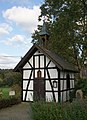
Antonius Chapel in Wahlfeld

Bönnschenhof

.png)
The Antonius Chapel in Wahlfeld is a listed half-timbered building with a saddle roof and turret from 1885. It was moved here from Uthweiler in 1982. The interior decoration includes a brick altar with a figure of the patron who is also set in a niche outside as a wooden figure.
The most important architectural monument , along with the Antonius Chapel, is the Bönnschenhof (formerly also Bönnscherhof ), a four-winged half-timbered courtyard from the 18th century. It includes a two-story house and a barn adjacent one as Backhaus erbauter brick building with half-timbered cultivation from the 19th century. The predecessor buildings of the Bönnschenhof are said to date back to the 12th century when it fell into the possession of the Bonn Cassius monastery . The agricultural use of the farm ended in 1993.
literature
- Angelika Schyma : City of Königswinter. (= Monument topography Federal Republic of Germany , monuments in the Rhineland , Volume 23.5.) Rheinland-Verlag, Cologne 1992, ISBN 3-7927-1200-8 , pp. 263/264.
Web links
- Antoniuskapelle Wahlfeld , parish community Kirche am Oelberg
- The Wahlfelder Mühle , Oberpleis Virtual Local History Museum
Individual evidence
- ↑ Designation according to the German basic map
- ^ Wilhelm Crecelius , Woldemar Harleß (ed.): Journal of the Bergisches Geschichtsverein , Volume 20, 1884, p. 130.
- ^ Wilhelm Fabricius : Explanations of the historical atlas of the Rhine province, 2nd volume: The map of 1789. Bonn 1898, p. 311.
- ↑ Official Journal for the Cologne District , 1841, page 11
- ^ Fr. Halm: Statistics of the administrative district of Cöln , Boisserée, 1865, S. ( Online Google Books )
- ↑ State Survey Office North Rhine-Westphalia: Directory of the landmarks ( Memento from April 17, 2012 in the Internet Archive ) (as of 2005; PDF; 243 kB)
- ↑ Alexander August Mützell, Leopold Krug (Ed.): New topographical-statistical-geographical dictionary of the Prussian state. Fifth volume. T-Z. With Karl August Kümmel, Halle 1823, p. 88 ( digitized version ).
- ^ Friedrich von Restorff: Topographical-statistical description of the Royal Prussian Rhine Province . Nicolaische Buchhandlung, Berlin / Stettin 1830, p. 303 ( digitized version ).
- ↑ Royal Government of Cologne (Ed.): Overview of the constituent parts and list of all the localities and individually named properties of the government district of Cologne, according to districts, mayorships and parishes, with information on the number of people and the residential buildings, as well as the Confessions, Jurisdictions , Military and earlier country conditions. Cologne 1845, p. 105 ( digitized version ).
- ^ Community encyclopedia for the province of Rhineland. Based on materials from the census of December 1, 1885 and other official sources, edited by the Royal Statistical Bureau. In: Royal Statistical Bureau (Hrsg.): Community encyclopedia for the Kingdom of Prussia. tape XII , 1888, ZDB -ID 1046036-6 , p. 18 ( digitized version ).
- ^ Community encyclopedia for the Rhine Province. Based on the materials from the census of December 1, 1905 and other official sources, edited by the Royal Prussian State Statistical Office. In: Königliches Prussisches Statistisches Landesamt (Hrsg.): Community encyclopedia for the Kingdom of Prussia. Booklet XII, 1909, ZDB -ID 1046036-6 , p. 151 .
- ↑ Royal Government of Cologne (Ed.): Overview of the constituent parts and list of all the localities and individually named properties of the government district of Cologne, according to districts, mayorships and parishes, with information on the number of people and the residential buildings, as well as the Confessions, Jurisdictions , Military and earlier country conditions. Cologne 1845, p. 103 ( digitized version ).
- ↑ Oberpleis Virtual Local History Museum. Werbekreis Oberpleis e. V., accessed on August 6, 2015 (history and photos of the Bönnschenhof).
Coordinates: 50 ° 43 ′ 16 ″ N , 7 ° 16 ′ 22 ″ E