Weihai
| Wēihǎi Shì 威海 Weihai |
||
|---|---|---|
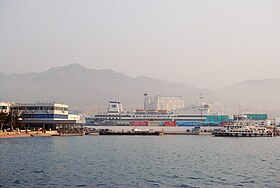
 Weihai Harbor |
||
|
|
||
| Coordinates | 37 ° 30 ' N , 122 ° 6' E | |
| Basic data | ||
| Country | People's Republic of China | |
| region | East china | |
| province | Shandong | |
| ISO 3166-2 | CN-SD | |
| status | Sub-provincial town | |
| structure | 2 city districts, 2 independent cities | |
| height | 923 m | |
| surface | 2606 km² | |
| Metropolitan area | 5797 km² | |
| Residents | 698,863 (2010) | |
| Metropolitan area | 2,819,300 (2016) | |
| density | 268.2 Ew. / km² | |
| Metropolitan area | 486.3 Ew. / km² | |
| Post Code | 264200 | |
| Telephone code | +86 (0) 631 | |
| Time zone | UTC + 8 | |
| Website | www.weihai.gov.cn (zh en) | |
| politics | ||
| mayor | Zhang Haibo ( 张海波 ) | |
Weihai ( Chinese 威海 市 , Pinyin Wēihǎi Shì , formerly 威海 衛 / 威海 卫 , Wēihǎiwèi ) is a city in the northeast of the Shandong Province of the People's Republic of China with an area of 5,797 km². In 2016, 2,819,300 inhabitants were counted. 698,863 people live in the actual urban settlement area of Weihai (2010 census).
Administratively, Weihai consists of two districts ( Huancui , Wendeng ) and two independent cities ( Rongcheng , Rushan ).
Weihai is the seat of a Roman Catholic bishop ( Weihai Apostolic Prefecture ). There are thermal springs in the city and there are many islands off the coast. British sailors nicknamed the city Way High .
history
Weihai was a base of the Chinese Navy. During the First Sino-Japanese War , the city was besieged and the warships that had previously been able to save themselves from the sea battle on the Yalu were destroyed in the port on February 2, 1895. The commanding Admiral Ding Ruchang then committed suicide.
British lease area
From July 1, 1898 to September 30, 1930, Weihai was a British lease under the name Weihaiwei. The contract provided for the assignment “as long as Port Arthur remains Russian.” After Port Arthur passed to Japan after the Russo-Japanese War in 1905, this provision was transferred to Japan. The port of Ma-tou was called Port Edward at that time . On the offshore island Liu-kung-tao (Liugong Dao, 劉 公 島 / 刘 公 岛 ) about 4,000 people lived in two villages. The 1911 census showed 147,177 inhabitants, including 215 Europeans, who lived in the approx. 330 villages within the leased area (size around 735 km²). About 4600 people lived in the city itself. The colonial administration was in deficit: income of £ 7,692 plus a grant of £ 5,000 compared to expenses of £ 14,805 in 1910/11. This deficit narrowed over the following years. On September 30, 1930, the lease area was handed over to the Chinese government in the presence of Governor Reginald Fleming Johnston .
In 1949, after the end of the Chinese Civil War and the communists came to power, the city was renamed.
Administrative structure
The district-free city of Weihai is made up of two districts and two urban districts. These are:
- Huancui District - 环翠 区Huáncuì Qū ( Seat of Government)
- Wendeng District - 文 登 区Wéndēng Qū
- Rongcheng City - 荣成 市Róngchéng Shì
- City of Rushan - 乳山 市Rǔshān Shì
Town twinning
-
 Santa Barbara , California, USA, since 1993
 -
 Sochi , Russia, since 1996
 -
 Sousse , Sahel , Tunisia , since 2007
 -
 Ube , Japan, since 1992
literature
- Kiaochow and Weihaiwei (= Handbooks prepared under the direction of the Historical Section of the Foreign Office . Vol. 71, ZDB -ID 2516626-8 ). HM Stationery Office, London 1920.
Web links
Individual evidence
- ↑ 地理位置 ("Geographical Location"). Weihai website, accessed August 19, 2018 (Chinese).
- ↑ Kiaochow and Weihaiwei . In: Handbooks prepared under the direction of the historical section of the Foreign Office . tape 71 . London 1920, p. 45-62 (English, online ).
- Jump up ↑ Latest Wire News: The Handover of Weihaiwei. The ceremonial. In: German-Chinese news = De-Hua-ribao . tape 1 , no. 1 . Tientsin October 1, 1930 ( online ).
- ^ Sister Cities. Santa Barbara, accessed June 20, 2017 .


