Wild Aa
|
Wilde Aa (Aar, Ogge, Wilde Ah, Wilde Aar) |
||
|
The catchment area of the Orke with the sub-catchment area of the Aar in the north and in the east (see dividing line) |
||
| Data | ||
| Water code | DE : 42846 | |
| location | Rothaargebirge ; Hochsauerlandkreis and Waldeck-Frankenberg District , North Rhine-Westphalia and Hesse ( Germany ) | |
| River system | Weser | |
| Drain over | Orke → Eder → Fulda → Weser → North Sea | |
| source | in the Rothaargebirge on the Krutenberg 51 ° 15 ′ 1 ″ N , 8 ° 37 ′ 44 ″ E |
|
| Source height | approx. 721 m above sea level NHN | |
| muzzle | in Dalwigksthal in the Orke coordinates: 51 ° 9 ′ 12 " N , 8 ° 46 ′ 26" E 51 ° 9 ′ 12 " N , 8 ° 46 ′ 26" E |
|
| Mouth height | approx. 305 m above sea level NHN | |
| Height difference | approx. 416 m | |
| Bottom slope | approx. 15 ‰ | |
| length | 27.1 km | |
| Catchment area | 126.417 km² | |
| Left tributaries | see below | |
| Right tributaries | see below | |
| Communities | Oberschledorn , Lichtenfels | |
|
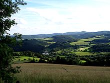
The valley of the Wilder Aar in Aarstruth , part of landscape 332.34 of the Ostsauerland mountain range , on the road on the Aar between Goddelsheim and Medebach ; View downstream to the south |
||
The Wilde Aa (also called Wilde A h , Ogge , Wilde A ar or A ar in different river sections) is a 27.1 km long, northern and orographically left tributary of the Orke in North Rhine-Westphalia and Hesse ( Germany ).
course
The Wilde Aa rises in the east of Westphalia in the Hochsauerlandkreis in the northeastern part of the Rothaargebirge . Its source is located about 1.7 km (as the crow flies ) west of Titmaringhausen (northwestern part of Medebach ) on the eastern flank of the Krutenberg - at about 721 m above sea level. NHN .
From there the Wilde Aa, sometimes also called Wilde Aa r from the upper reaches to the Hessian border , flows eastwards via Titmaringhausen to Referinghausen (northern district of Medebach), from where the stream is sometimes also called Wilde A h . To the east of Oberschledorn (northern district of Medebach) the flowing water , now sometimes referred to as Ogge , reaches the north-western part of northern Hesse , from where the stream is also only known as the Aar . East of Nieder-Schleidern , located in the Waldeck-Frankenberg district (west-southwest district of Korbach ), its longest tributary flows into the Neerdar, which comes from the north .
Then the Aar flows through Eppe (southwestern district of Korbach) and below or south of it through an approximately 9.5 km long valley section, in which it is not accompanied by roads and does not flow through any villages, although this area belongs to the municipality of Lichtenfels ; only two district roads cross in this area .
To the east of the town of Münden , a district of Lichtenfels , the Aar takes on an artificially created flood channel about 130 m long, branched off from the Orke.
Finally , in the Dalwigksthal district of Lichtenfels , the Aar flows under a bridge on Landesstraße 3076 (Orketalstraße) at around 305 m above sea level into the western Eder tributary Orke , which runs underground for around 150 m along the L 3076 directly before the mouth of the Aar.
Watershed
The headwaters of the Wilden Aa (Aar) lie on the Diemel-Eder / Fulda / Weser watershed : While its water flows mainly in a south-easterly direction and makes a more southerly detour through the Orke , Eder and Fulda to the Weser , that of the Diemel , for example, runs which rises a little further north on the northeast slope of the Auf'm Knoll mountain, heading northeast directly into the Weser.
Tributaries
The tributaries of the Wild Aa (Aar) and its tributaries include with orographic allocation (l = left-hand side; r = right-hand side), length in kilometers and estuary (viewed downstream):
|
|
References and comments
- ↑ a b c Topographical Information Management, Cologne District Government, Department GEObasis NRW ( information )
- ↑ Map services of the Federal Agency for Nature Conservation ( information )
- ↑ a b Water map service of the Hessian Ministry for the Environment, Climate Protection, Agriculture and Consumer Protection ( information )
- ↑ Location of the flood canal as a connection between Orke and Aar: ⊙ (inlet in the southwest) and ⊙ (outlet in the northeast)


