Witim
|
Witim Вити́м |
||
|
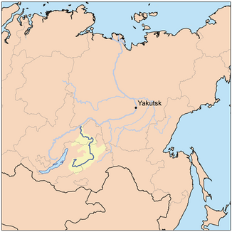
Eastern Siberia with the Witim catchment area |
||
| Data | ||
| Water code | RU : 18030200112117100015361 | |
| location | Buryatia , Transbaikalia Region , Irkutsk Oblast , Sakha Republic ( Russia ) | |
| River system | Lena | |
| Drain over | Lena → Arctic Ocean | |
| confluence | of Vitimkan and Tschina 54 ° 20 ′ 23 ″ N , 112 ° 25 ′ 13 ″ E |
|
| Source height | 1171 m | |
| muzzle | in the Lena near Witim Coordinates: 59 ° 27 '10 " N , 112 ° 35' 49" E 59 ° 27 '10 " N , 112 ° 35' 49" E |
|
| Mouth height | 176 m | |
| Height difference | 995 m | |
| Bottom slope | 0.54 ‰ | |
| length | 1837 km (with source river Witimkan 1978 km) | |
| Catchment area | 225,000 km² | |
| Discharge at the Bobaido A Eo gauge : 186,000 km² Location: 294 km above the mouth |
MQ 1912/1990 Mq 1912/1990 |
1560 m³ / s 8.4 l / (s km²) |
| Discharge at the gauge near the mouth |
MQ |
2000 m³ / s |
| Left tributaries | Konda , Zipa , Muja , Mamakan , Mama | |
| Right tributaries | Karenga , Kalakan , Kalar , Kuanda , Sygykta , Bodaibo | |
| Medium-sized cities | Bodaibo | |
| Navigable | from Bodaibo | |
|
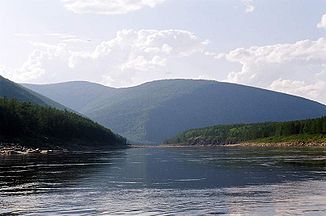
Witim (middle course) near Bambuyki |
||
|
Catchment area of the Witim with tributaries |
||
|
Witimkan Вити́мкан |
||
| Water code | RU : 18030200112117100015378 | |
| River system | Lena | |
| Drain over | Witim → Lena → Arctic Ocean | |
| source | in the Ikat Mountains 53 ° 50 ′ 17 ″ N , 111 ° 9 ′ 56 ″ E |
|
| Union | with Tschina to Witim 54 ° 20 ′ 23 ″ N , 112 ° 25 ′ 13 ″ E |
|
| Mouth height |
1171 m
|
|
| length | 141 km | |
| Catchment area | 2580 km² | |
| Discharge at the Iwanowski A Eo gauge : 969 km² Location: 62 km above the mouth |
MQ 1957/1990 Mq 1957/1990 |
8.8 m³ / s 9.1 l / (s km²) |
|
Tschina Чина |
||
| Water code | RU : 18030200112117100015644 | |
| River system | Lena | |
| Drain over | Witim → Lena → Arctic Ocean | |
| source |
Babanty Mountains ( Witim Plateau ) 54 ° 43 ′ 1 ″ N , 113 ° 30 ′ 23 ″ E |
|
| Union | with Witimkan to Witim 54 ° 20 ′ 23 ″ N , 112 ° 25 ′ 13 ″ E |
|
| Mouth height |
1171 m
|
|
| length | 132 km | |
| Catchment area | 1830 km² | |
| Right tributaries | Tschinakan | |
The Witim ( Russian Вити́м ) is a 1837 km (with the right source river Witimkan 1978 km) long, southern and orographically right tributary of the Lena in Siberia ( Asian part of Russia ).
Course and catchment area
The Vitim arises almost 200 km as the crow flies east of Lake Baikal , in the eastern foothills of the Ikat Mountains (Ikatski chrebet) not far from the settlement of Warvarinski from the source rivers Witimkan from the right and Tschina from the left. The longer source river Witimkan rises about 100 km southwest of this point, in the southern part of the 2500 m high Ikat Mountains at an altitude of about 2100 m . From its origin, the Witim meanders first in a southerly, then in an easterly to north-easterly direction along the south-eastern edge of the Witim plateau and runs northwest of the Jablonowy Mountains . Later he turns north, breaks through the mountain ranges of the Stanovoi highlands and reaches the settlement of Witim . There it flows into the Lena with several arms.
The catchment area of the Witim, which is only navigable in its lower reaches from the city of Bodaibo , covers 225,000 km².
Web links
Individual evidence
- ↑ a b c Article Witim in the Great Soviet Encyclopedia (BSE) , 3rd edition 1969–1978 (Russian)
- ↑ a b Witim in the State Water Register of the Russian Federation (Russian)
- ↑ Vitim at the level Bobaido - hydrographic data for R-ArcticNet
- ↑ a b Witikan in the State Water Directory of the Russian Federation (Russian)
- ↑ Witimkan at the Iwanowski gauge - hydrographic data at R-ArcticNET
- ↑ a b Tschina in the State Water Register of the Russian Federation (Russian)


