
Degersheim SG
| SG is the abbreviation for the canton of St. Gallen in Switzerland and is used to avoid confusion with other entries of the name Degersheim . |
| Degersheim | |
|---|---|
 |
|
| State : |
|
| Canton : |
|
| Constituency : | Wil |
| BFS no. : | 3401 |
| Postal code : | 9113 |
| UN / LOCODE : | CH DGS |
| Coordinates : | 732 766 / 248349 |
| Height : | 800 m above sea level M. |
| Height range : | 634-1060 m above sea level M. |
| Area : | 14.48 km² |
| Residents: | 4130 (December 31, 2018) |
| Population density : | 285 inhabitants per km² |
| Website: | www.degersheim.ch |
 Degersheim SG |
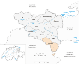
|
| Location of the municipality | |
  |
|
Degersheim , in the Swiss German local dialect Tegersche [ˈtegərʃə] , is a political municipality in the constituency of Wil in the Swiss canton of St. Gallen .
geography
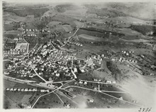
Degersheim is located on the south- east railway line St. Gallen - Wattwil - Nesslau-Neu St. Johann . Degersheim is embedded in a hilly landscape.
The lowest point in Degersheim is in the Bubental at 647 m above sea level. The highest point is at the Degersheim exclave Obergampen at 1061 m above sea level. M. The station is at 798 m above sea level. The community area is 1448 hectares, of which 793 hectares are meadows and fields, 509 hectares of forest, 46 hectares of roads, paths or railways, 25 hectares of building land and 5 hectares of water.
Degersheim is drained by the Aachbach, which flows into the Necker, and the Talbach , a tributary of the Wissbach .
The village of Wolfertswil with the Magdenau monastery belongs to the municipality of Degersheim . Above Wolfertswil lies the lowest high moor on the north side of the Alps, the Rotmoos . The neighboring communities are Oberuzwil , Flawil , Herisau , Schwellbrunn , Neckertal and Lütisburg . The Obergampen exclave borders on Schwellbrunn and Neckertal.
Degersheim is a starting point for hikes and bike tours in summer. For the winter, Degersheim offers three ski lifts with floodlit slopes for night skiing and a cross-country ski run .

population
Degersheim has 4130 inhabitants (December 31, 2018). 713 foreigners live in the community, 36.50% were Catholic and 30.06% were Reformed (May 31, 2015).
| year | 1816 | 1850 | 1900 | 1910 | 1941 | 1950 | 1990 | 2000 | 2010 | 2015 |
| population | 1067 | 1620 | 3414 | 3766 | 2966 | 3186 | 4065 | 3952 | 3905 | 3975 |
history
837 Degersheim is mentioned as Tegarasgai , Wolfertswil in 838 as Wolfridenswilare . “Degersheim” is not an original -heim name, but is made up of the Old High German tëgar “large, extensive” and asca “ash, rowan”. The dialectal Tegersche , which was developed by law, was only reinterpreted as "Degersheim" in modern times.
In the 13th century the foundation stone was laid for the Magdenau Monastery , located in the Degersheim- Flawil - Uzwil triangle . The residents of Degersheim belonged to the parish of Oberglatt near Flawil and built their own chapel at the end of the 15th century. In 1708 they broke away from Oberglatt and bought themselves free in 1808 for 2,897 guilders.
The population lived mainly from cattle breeding and grain growing. A mill is mentioned in 1447. In the 17th century, the Magdenau monastery received the infrastructure that still exists today. In 1708 the Protestant and in 1763 the Catholic parish was founded. The cotton weaving mill has found its way into Degersheim since around 1750 .
1803 Degersheim became a political municipality in the canton of St. Gallen. Since then Degersheim is also the official, official name. The original name Tegerschen is still in use today among the local population.
In 1804 Magdenau and Degersheim merged. In 1818 a fire destroyed 40 houses, 15 barns and the church. 200 people were left homeless. Around 1860 Degersheim experienced an economic boom thanks to the embroidery industry. Up to 900 people were employed in this branch. In 1910 Degersheim was connected to the rail network. After the embroidery industry had a crisis, Degersheim's main focus since 1930 has been metal and wood processing. The company AS Aufzüge AG currently comprises Wolfertswil around 120 employees.
Until 2002 Degersheim belonged to the Untertoggenburg district. As part of the administrative revision due to the new cantonal constitution, the municipality came to the constituency of Wil in 2003.
Attractions
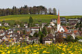
- The former parish church of St. Verena is located near the Magdenau monastery . The oldest components go back to the Romanesque period .
- Reformed church Degersheim, built in 1908 in the local style , architects: Curjel & Moser, Karlsruhe / St. Gallen
- St. Jakobus Catholic Church, Degersheim, built in neo-baroque style in 1924 , architects: Danzeisen & Hunziker, Degersheim
- Catholic Church of Brother Klaus, Wolfertswil, built in 1952, architect: Willi Schregenberger, St. Gallen
traffic
The Degersheim SOB station is connected to the St. Gallen S-Bahn network. The S4 and S8 serve the station. The interregional trains of the Voralpen-Express ( Romanshorn - Lucerne ) no longer stop due to the expansion of the S-Bahn since December 2013. A PostBus line connects Degersheim via Wolfertswil and Magdenau with Flawil and guarantees a connection to the SBB network . Another post bus line leads via Dicken to St. Peterzell in Neckertal.
Partnerships
Degersheim maintains a city partnership with the municipality of Chamoson VS .
Sons and daughters of the church
- Monika Ribar (* 1959), manager
photos

Catholic Church
reformed Church


literature
- Beat Bühler: Degersheim. In: Historical Lexicon of Switzerland .
- Bernhard Anderes and Hans Peter Mathis: The Cistercian convent Magdenau. Bern 2003 (Swiss Art Guide GSK, Volume 731), ISBN 3-85782-731-9 .
Web links
Individual evidence
- ↑ Permanent and non-permanent resident population by year, canton, district, municipality, population type and gender (permanent resident population). In: bfs. admin.ch . Federal Statistical Office (FSO), August 31, 2019, accessed on December 22, 2019 .
- ↑ a b Lexicon of Swiss municipality names . Edited by the Center de Dialectologie at the University of Neuchâtel under the direction of Andres Kristol. Frauenfeld / Neuenburg 2005, p. 290.
- ↑ StiASG , Urk. II 142. Online at e-chartae , accessed on June 19, 2020.
- ^ Johann Friedrich Franz: Church news about the Protestant communities of Toggenburg, Canton St. Gallen. Ebnat 1824, p. 186 ff.
Degersheim | Flawil | Jonschwil | Niederbüren | Niederhelfenschwil | Oberbüren | Oberuzwil | Uzwil | Wil | Zuzwil
Former municipality: Bronschhofen
Canton of St. Gallen | Constituencies of the Canton of St. Gallen | Municipalities of the Canton of St. Gallen