
Grünheide (Mark): Difference between revisions
No edit summary |
No edit summary |
||
| Line 3: | Line 3: | ||
|type = |
|type = |
||
|image_coa = Wappen Gruenheide (Mark).png |
|image_coa = Wappen Gruenheide (Mark).png |
||
|image_photo = Werlsee 05.jpg |
|||
|image_caption = Lake Werlsee |
|||
|Wappengröße = 110 |
|Wappengröße = 110 |
||
|coordinates = {{coord|52|25|00|N|13|49|00|E|format=dms|display=inline,title}} |
|coordinates = {{coord|52|25|00|N|13|49|00|E|format=dms|display=inline,title}} |
||
| Line 30: | Line 32: | ||
==Geography== |
==Geography== |
||
[[File:Werlsee 05.jpg|thumb|Lake Werlsee]] |
|||
<!-- === Neighboring places === --> |
<!-- === Neighboring places === --> |
||
Grünheide lies in the northwest of the [[Oder-Spree District]] (German: ''Landkreis Oder-Spree'', [[Lower Sorbian]]: ''Wokrejs Odra-Sprjewja''; seat: [[Beeskow]] (Lower Sorbian: ''Bezkow'')), directly bordering the [[Märkisch-Oderland District]] (seat: [[Seelow]]) to the north. Grünheide is clockwise surrounded by the municipalities of [[Rehfelde]], [[Müncheberg]], [[Steinhöfel]], [[Fürstenwalde/Spree]], [[Spreenhagen]], [[Gosen-Neu Zittau]], [[Erkner]], [[Woltersdorf (bei Berlin)]], and [[Rüdersdorf bei Berlin]]. |
|||
===Division of the town=== |
===Division of the town=== |
||
Revision as of 14:45, 26 February 2020
Grünheide (Mark) | |
|---|---|
 Lake Werlsee | |
.png) Coat of arms | |
Location of Grünheide (Mark)  | |
 Grünheide (Mark)  Grünheide (Mark) | |
| Coordinates: 52°25′00″N 13°49′00″E / 52.41667°N 13.81667°E | |
| Country | Germany |
| State | Brandenburg |
| District | Oder-Spree |
| Subdivisions | 6 districts |
| Government | |
| • Mayor | Arne Christiani (Ind.) |
| Area | |
| • Total | 125.92 km2 (48.62 sq mi) |
| Elevation | 35 m (115 ft) |
| Population (2022-12-31)[1] | |
| • Total | 9,152 |
| • Density | 73/km2 (190/sq mi) |
| Time zone | UTC+01:00 (CET) |
| • Summer (DST) | UTC+02:00 (CEST) |
| Postal codes | 15537 |
| Dialling codes | 03362 |
| Vehicle registration | LOS |
| Website | www.gemeinde-gruenheide.de |
Grünheide (Mark) is a municipality in the Oder-Spree district, in Brandenburg, Germany. It is situated south-east of Berlin on the River Löcknitz.
Etymology
The name "Grünheide" is a compound of grün (green) and Heide (heath). Mark means march (see March of Brandenburg).
Geography
Grünheide lies in the northwest of the Oder-Spree District (German: Landkreis Oder-Spree, Lower Sorbian: Wokrejs Odra-Sprjewja; seat: Beeskow (Lower Sorbian: Bezkow)), directly bordering the Märkisch-Oderland District (seat: Seelow) to the north. Grünheide is clockwise surrounded by the municipalities of Rehfelde, Müncheberg, Steinhöfel, Fürstenwalde/Spree, Spreenhagen, Gosen-Neu Zittau, Erkner, Woltersdorf (bei Berlin), and Rüdersdorf bei Berlin.
Division of the town
Grünheide consists of the following districts:
- Grünheide (Mark) with the villages Grünheide, Alt Buchhorst, Bergluch, Gottesbrück and Fangschleuse
- Hangelsberg
- Kagel
- Kienbaum
- Mönchwinkel
- Spreeau
Demographics
|
|
|
-
![Population change comparison: Grünheide (Mark) versus Brandenburg state (1875 - present)]. The development of the Grünheide (Mark) population since 1875 within the current boundaries (blue line) and its comparison to the population development of Brandenburg state (dotted line). Also illustrated is the population during the time of Nazi rule (grey background) and during the time of Communist rule (red background).](//upload.wikimedia.org/wikipedia/commons/thumb/5/57/Bev%C3%B6lkerungsentwicklung_Gr%C3%BCnheide.pdf/page1-530px-Bev%C3%B6lkerungsentwicklung_Gr%C3%BCnheide.pdf.jpg) Population change comparison: Grünheide (Mark) versus Brandenburg state (1875 - present)]. The development of the Grünheide (Mark) population since 1875 within the current boundaries (blue line) and its comparison to the population development of Brandenburg state (dotted line). Also illustrated is the population during the time of Nazi rule (grey background) and during the time of Communist rule (red background).
Population change comparison: Grünheide (Mark) versus Brandenburg state (1875 - present)]. The development of the Grünheide (Mark) population since 1875 within the current boundaries (blue line) and its comparison to the population development of Brandenburg state (dotted line). Also illustrated is the population during the time of Nazi rule (grey background) and during the time of Communist rule (red background). -
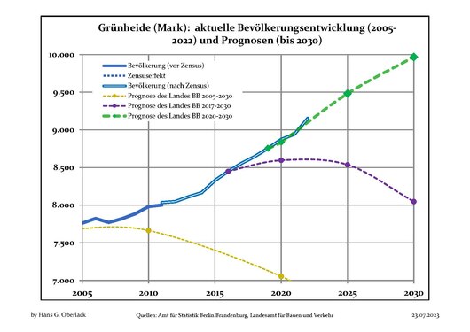 Recent Population Development and Projections (Population Development before Census 2011 (blue line); Recent Population Development according to the Census in Germany in 2011 (blue bordered line); Official projections for 2005-2030 (yellow line); for 2014-2030 (red line); for 2017-2030 (scarlet line)
![Population change comparison: Grünheide (Mark) versus Brandenburg state (1875 - present)]. The development of the Grünheide (Mark) population since 1875 within the current boundaries (blue line) and its comparison to the population development of Brandenburg state (dotted line). Also illustrated is the population during the time of Nazi rule (grey background) and during the time of Communist rule (red background).](http://upload.wikimedia.org/wikipedia/commons/thumb/5/57/Bev%C3%B6lkerungsentwicklung_Gr%C3%BCnheide.pdf/page1-530px-Bev%C3%B6lkerungsentwicklung_Gr%C3%BCnheide.pdf.jpg)

Personalities

- Curt Herrmann (1854-1929), Impressionist, lived in the mansion with a tower in the village part of the Hangelsberg from the year 1750.
- Fritz Rasp (1891-1976), actor, lived during his time in Berlin in his own house in what is today's Mönchwinkel.
- Robert Havemann (1910-1982), chemist, communist, resistance fighter against the National Socialism and Critical Critic in the GDR. Havemann lived in his house in today's district of Grünheide from 1976 to 1979 because of his criticism of the SED
See also
References
- ^ "Bevölkerungsentwicklung und Bevölkerungsstandim Land Brandenburg Dezember 2022" (PDF). Amt für Statistik Berlin-Brandenburg (in German). June 2023.
- ^ Detailed data sources are to be found in the Wikimedia Commons.Population Projection Brandenburg at Wikimedia Commons
External links
![]() Media related to Grünheide (Mark) at Wikimedia Commons
Media related to Grünheide (Mark) at Wikimedia Commons
- Official website (in German)
- Tourism in Grünheide (in German)
Towns and municipalities in Oder-Spree | ||
|---|---|---|
|  | |
| International | |
|---|---|
| National | |
| Geographic | |
This Brandenburg location article is a stub. You can help Wikipedia by expanding it. |