
Almirante Tamandaré
| Município de Almirante Tamandaré "Cidade dos Minérios"
Almirante Tamandaré
"Pólo da Informática e das Telecomunicações" |
|||
|---|---|---|---|
 City entrance with stylized semaphores for the city nickname Pólo da Informática e das Telecomunicações
|
|||
|
|||
| Coordinates | 25 ° 20 ′ S , 49 ° 19 ′ W | ||
 Location of the municipality in the state of Paraná Location of the municipality in the state of Paraná
|
|||
| Symbols | |||
|
|||
| founding | 20th October 1889 (age 130) | ||
| Basic data | |||
| Country | Brazil | ||
| State | Paraná | ||
| ISO 3166-2 | BR-PR | ||
| structure | 161 bairros | ||
| height | 950 m | ||
| climate | subtropical, cfb | ||
| surface | 194.7 km² | ||
| Residents | 103,204 (2010) | ||
| density | 529.9 Ew. / km² | ||
| estimate | 118,623 (July 1, 2019) | ||
| Parish code | IBGE : 4100400 | ||
| Post Code | 83501-000 | ||
| Telephone code | (+55) 51 | ||
| Time zone | UTC −3 | ||
| Website | tamandare.pr (Brazilian Portuguese) | ||
| politics | |||
| City Prefect | Gerson Denilson Colode (2017-2020) | ||
| Political party | MDB | ||
| Culture | |||
| Patron saint | Maria as "Nossa Senhora da Imaculada Conceição" | ||
| economy | |||
| GDP | 1,396,289 thousand R $ 12,234 R $ per person (2016) |
||
| HDI | 0.699 (medium high) (2010) | ||
 City Hall, City Prefecture Building
|
|||


Almirante Tamandaré (officially: Município de Almirante Tamandaré , formerly: Villa Tamandaré ; German: Admiral-Tamandaré-Stadt ) is a city in the Brazilian state of Paraná . It is located at an altitude of 950 meters above sea level and is around 15 kilometers from the capital Curitiba . In 2010 it had just over 103,000 inhabitants, called tamandareenses (Tamandarese) in Portuguese . The population was estimated to be 118,623 as of July 1, 2019. It ranks 17th out of 399 municipalities in the state.
geography
The city of Almirante Tamandaré is located in the southeast of Parana in the catchment area of Curitiba, the federal capital. Almirante Tamandaré borders Itaperuçu and Rio Branco do Sul to the north, Curitiba to the south, Colombo to the east and Campo Magro to the west . The area is around 195 km², which corresponds to 0.0979% of the state area, 0.0346% of the south of Brazil and 0.0023% of Brazil.
Geologically, it has its origins in the Proterozoic , formed with slate , marble , quartz and basic rock . The brown earth (Cambisol) dominates the soil . There are also types of soil such as Acrisol , Latosol and Nitosol . From an orographical point of view, the city resembles a mountain due to the undulating terrain. The height is up to 1200 meters. The area belongs to the first high plateau of Paraná, the Primeiro planalto paranaense .
At the time of the discovery of Brazil (1500), there were two original types of vegetation on today's urban area: araucaria forests and prairie .
Geostastics
She was from 1989 to 2017 one of the 19 municipalities of geostatistical Mikroregion Microrregião de Curitiba within the mesoregion Mesorregião Metropolitana de Curitiba and the metropolitan region Região Metropolitana de Curitiba . They served the Brazilian statistical office and were not local authorities. The IBGE has been using a different classification since 2017.
Hydrography
The area belongs to two water catchment areas, the Río Iguaçu and Río Ribeira de Iguape . The main tributary of the Iguaçu is the Barigui River with its tributary Passaúna . The Juruqui is one of the few tributaries of the Passaúna in the Tamandaren area.
climate
The urban climate is subtropical, humid and mesothermal and corresponds to a good, pleasant and healthy climate: relatively hot in summer and fresh (with occasional frost) in winter. The mean temperatures registered annually: max. 26 ° C, min. 12 ° C and balanced 19 ° C. The fresh summers have a soil temperature of 22 ° C. In winter there are frequent, severe frosts with a mean soil temperature of 18 ° C. Annual rainfall ranges between 1,400 and 1,500 mm.
history
- Origin of name
Namesake is the Brazilian admiral Marquês de Tamandaré Joaquim Marques Lisboa (1807-1897). The word Tamandaré comes from the Tupi language : "tab-moi-inda-ré", something that humans created. In the state of Rio Grande do Sul there is also a city named after Lisboa Almirante Tamandaré do Sul .
Demographics
| Statistical information (as of 2010) | |||||||||||
|---|---|---|---|---|---|---|---|---|---|---|---|
| year | 2000 | 2010 | |||||||||
| Total population | |||||||||||
| District | 88,277 | 103.204 | |||||||||
| - urban | 98,892 | ||||||||||
| - rural | 4,312 | ||||||||||
| Race distribution | |||||||||||
| White (blanca) | 63,684 | 66,865 | |||||||||
| Blacks (preta) | 3,516 | 4.064 | |||||||||
| Mixed race (parda) | 19,862 | 31,687 | |||||||||
| Yellow | 180 | ||||||||||
| Indigenous people | 318 | ||||||||||
| Genders | |||||||||||
| Men | 44.112 | 51,136 | |||||||||
| Women | 44,165 | 52,068 | |||||||||
| Source: IBGE (2010) | |||||||||||
City administration
List of city prefects
- 1948 - 1951: João Wolf ( PSD )
- 1952 - 1955: Ambrosio Bini
- 1956 - 1959: João Wolf ( PSD )
- 1960 - 1963: Ambrosio Bini ( PDC )
- 1964 - 1968: Domingos Natal Stocchero ( PDC - UDN )
- 1969 - 1972: Antonio Johnson ( MDB )
- 1973 - 1976: Euripedes de Siqueira ( ARENA )
- 1977 - 1982: Roberto Luiz Perussi ( MDB )
- 1983 - 1988: Ariel Adalberto Buzzato ( PDS )
- 1989 - 1992: Roberto Luiz Perussi ( PDT )
- 1993 - 1996: Arcenideo Felix Gulin (Cide Gulin) ( PDT )
- 1997 - 2000: Cezar Manfron ( PPB )
- 2001 - 2004: Cezar Manfron ( PTB )
- 2005 - 2008: Vilson Goinski ( PMDB )
- 2009 - 2012: Vilson Goinski ( PMDB )
- 2013 - 2016: Aldnei Siqueira ( PSD )
- 2017 - in office of Gerson Denilson Colode ( MDB )
Infrastructure
education
According to the city prefecture, 17 state and 31 city schools are operated. 16,923 primary school students and 3,464 high school students were enrolled (as of 2010). The illiteracy rate in 2010 was 6.06%.
| Literacy | |||||||||||
|---|---|---|---|---|---|---|---|---|---|---|---|
| year | 2000 | 2010 | |||||||||
| Illiteracy in percent | |||||||||||
| 13.11% | 6.06% | ||||||||||
| Source: IBGE (2010) | |||||||||||
traffic
- Bus: Almirante Tamandaré is connected to Curitiba at the Cabral bus transfer station with the high-speed line 105 Tamandaré - Cabral of the "Integrated Transport Network " Rede Integrada de Transporte (RIT) in the local transport network of the metropolitan region of Curitiba.
- Airport: The city does not have its own airport. The closest is Afonso Pena International Airport ( IATA : CWB, ICAO : SBCT) in Curitiba.
Tourist destinations

- Antigua Prefeitura (Old Prefecture)
- The building is a symbol of urban development and independence of the place, which was built at the instigation of the local mayor Coronel João Cândido de Oliviera. The inauguration as the seat of the city prefecture took place on March 26, 1916. Today it houses the Harley Clóvis Stocchero Municipal Library (Biblioteca Pública Municipal Harley Clóvis Stocchero) and the city's cultural department. On March 25, 1994, the Old Prefecture was entered under No. 119-II in the list of monuments of the Patrimônio Histórico e Artístico do Estado do Paraná .
- Igreja Nossa Senhora da Luz (Church of Our Lady of Light)
- The church, built on a rocky hill in 1882, is also known as Igreja de Marmeleiro . The interior design was created by an Italian artist whose name has not been passed down.
- Monte Dalledone
- The Monte Dalledone is an abandoned limestone quarry that can only be reached on foot. Above there is a large stone block from which a panoramic view of the city and the surrounding area is offered.
sons and daughters of the town
- Albano Agner de Carvalho (1899–1992), landscape painter, watercolorist
- Harley Clóvis Stocchero (1926–2005), lawyer, scientist, honorary citizen
Picture gallery
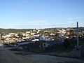
View of Almirante Tamandaré

Harley Clóvis Stocchero Municipal Library

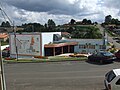
Central bus station

Colégio Interação
City Chamber Building
(Câmara Municipal)


literature
- Harley Clóvis Stocchero : Raízes Históricas de Almirante Tamandaré. Travessa dos Editores, Curitiba 2012, ISBN 978-85-64913-02-8 .
- João Carlos Vicente Ferreira: O Paraná e seus municípios . Editora Memória do Brasil, Maringá, Paraná 1996, pp. 137f.
- Jurandyr Pires Ferreira: Enciclopédia dos Municípios Brasileiros . Instituto Brasileiro de Geografia e Estatística, Rio de Janeiro 1959, Volume 31, pp. 25-27.
Web links
- Website of the prefecture of Almirante Tamandaré. (Brazilian Portuguese).
- Instituto Paranaense de Desenvolvimento Econômico e Social: Perfil do Município de Almirante Tamandaré. (Brazilian Portuguese).
- Instituto Brasileiro de Geografia e Estatística (IBGE): Sinopse do Censo Demográfico 2010: Paraná. (Brazilian Portuguese).
- Síntese das Informações de Almirante Tamandaré (PR) on the Informações do Brasil website(Brazilian Portuguese).
- Almirante Tamandaré, Câmara Municipal: História. (Brazilian Portuguese, historical overview).
Individual evidence
- ↑ a b c Almirante Tamandaré - Panorama. In: cidades.ibge.gov.br. IBGE , accessed October 3, 2019 (Brazilian Portuguese).
- ^ Helio Olympio da Rocha: The soils and geomorphological units of the region of Curitiba (Paraná, Brazil). Institute for Soil Science and Forest Nutrition of the Albert-Ludwigs-University, Freiburg im Breisgau 1981. (At the same time: Freiburg, Breisgau, University, Forest Science Faculty, dissertation, 1981). ( Summary ), accessed July 13, 2013.
- ^ Regina Obata: O Livro dos Nomes. Nobel, São Paulo 2002, ISBN 85-213-0808-6 , p. 181.
- ↑ IBGE: Sinopse do Censo Demográfico - 2010: Paraná
- ↑ Gerson Colodel 15 (Prefeito). In: todapolitica.com. Eleições 2016, accessed October 3, 2019 (Brazilian Portuguese).
- ↑ Overview of state schools ( page no longer available , search in web archives ) Info: The link was automatically marked as defective. Please check the link according to the instructions and then remove this notice. (Portuguese, accessed July 18, 2013).
- ↑ Overview of municipal schools ( Memento of the original from January 20, 2016 in the Internet Archive ) Info: The archive link has been inserted automatically and has not yet been checked. Please check the original and archive link according to the instructions and then remove this notice. (Portuguese, accessed July 18, 2013).
- ^ Entry in the Paraná State Monuments List (Brazilian Portuguese, accessed July 17, 2013).
- ^ Carvalho, Albano Agner de ( 1899-1992 ) in the enciclopédia Itaú Cultural, artes visuais (Brazilian Portuguese, accessed July 17, 2013).
- ↑ Albano Agner de Carvalho , biography on the Albano Agner website (Brazilian Portuguese, accessed July 17, 2013).