
On the sand between Hergershausen and Altheim
|
On the sand between Hergershausen and Altheim
|
||
 Nature reserve "Auf dem Sand", view from the dune onto shallow water areas and wet meadows (2014) |
||
| location | Hergershausen and Münster , Darmstadt-Dieburg district , Hesse | |
| surface | 23.25 hectares | |
| Identifier | 1432025 | |
| WDPA ID | 318135 | |
| Geographical location | 49 ° 56 ' N , 8 ° 53' E | |
|
||
| Setup date | October 12, 1998 | |

On the sand between Hergershausen and Altheim is a nature reserve in the districts of Babenhausen and Munster in the Darmstadt-Dieburg district , in southern Hesse . The protected area was designated by ordinance of October 12, 1998.
location
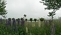
The area "On the sand between Hergershausen and Altheim" lies in the natural area of the Untermainebene - Gersprenz lowlands . The nature reserve is located north of Altheim between Münster and Hergershausen. It has an area of 23.25 hectares. In the north it borders on the nature reserve " Die kleine Qualle von Hergershausen ".
Protection purpose
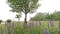
By placing it under protection, the extensively used wet meadows , fields, fallow land, ponds, shallow water areas, field trees and dry sand areas are to be preserved. These biotopes are habitat, wintering and resting areas for endangered and threatened animal and plant species. The areas are to be networked with the nature reserve “Die kleine Qualle von Hergershausen” and the Gersprenzaue through maintenance measures.
The Hergershausen meadows
“On the sand between Hergershausen and Altheim” was the second protected area in the Hergershausen meadows in 1998. The river basin of the Gersprenz was increasingly degraded to an arable steppe by canalization in 1940, drainage and ditch deepening in the 1950s as well as lowering of the groundwater through drinking water extraction. In 1970 there were 170 hectares of meadows. When the first nature reserve "Die Kleine Qualle" was designated in 1984, only 27 hectares of meadows remained between Hergershausen and Münster.
In the meantime, the Gersprenz has been renatured in the Hergershausen meadows area. Since 2008, as amended in 2016, these two nature reserves have been embedded in the larger Natura2000 areas “Untere Gersprenz” (FFH area 6019-303) and “Untere Gersprenzaue” (EU bird protection area 6119-401), Hergershausen sub-area.

NSG "Auf dem Sand": shallow water area, wet meadows, gray geese (2019)
Pools, pollarded willows, lupins (2016)
Pools, fruit trees, stork's nest (2016)
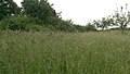
Meadows, hedges and fruit trees (2016)

View from the inland dune in the NSG "Auf dem Sand" onto the meadows of the NSG "Die kleine Qualle" (2020)

.jpg)
.jpg)
.jpg)

A BioTopTour of the Darmstadt-Dieburg district leads through the Hergershäuser Wiesen (hiking route 5.5 km, cycling route 12 km).
See also
Individual evidence
- ↑ a b c Ordinance on the nature reserve "On the sand between Hergershausen and Altheim" of October 12, 1998. PDF. State gazette for the state of Hesse, issue No. 45/1998, p. 3466, accessed on June 12, 2020 .
- ↑ a b Albrecht Ensgraber: Hesse's new nature reserves (15). Vogel und Umwelt Volume 4, Issue 3, pp. 132–152. 1986. (pp. 135-136).
- ↑ a b c map of the nature reserve. natureg.hessen.de, accessed on July 10, 2020 .
- ↑ Ordinance on the Natura 2000 areas in the Darmstadt administrative district of October 20, 2016. PDF. Darmstadt Regional Council, accessed on June 12, 2020 .
- ↑ Management plan for the FFH and VS area "Untere Gersprenz-FFH / Untere Gersprenzaue-VSG-TR Hergershausen" (6019-303 / 6119-401). dated December 16, 2010. PDF. Darmstadt Regional Council, accessed on June 12, 2020 .
- ↑ 7. BioTopTour: Through the Hergershausen meadows in the Gersprenzaue (hiking tour 2012 or bike tour 2002). Darmstadt-Dieburg district, accessed on August 21, 2020 .
Web links

Altneckarlachen from Alsbach, Hähnlein and Bickenbach | At the Kleewoog of Graefenhausen | On the sand between Hergershausen and Altheim | Brackenbruch near Hergershausen | Broken meadows of Dorndiel | Buchertsgräben near Schlierbach | The great Hörmes (Dieburg) | The little jellyfish from Hergershausen | Faulbruch near Erzhausen | Faulbruch von Munster | Foal pasture from Dieburg | Forstberg von Ueberau | Fuchswiese near Stettbach | Griesheimer Bruch | Big and small break near Roßdorf | Hegbachaue near Messel | Herrnberg von Groß-Umstadt | In the Dulbaum near Alsbach | Sand-lime pine forest near Bickenbach, Pfungstadt and Seeheim-Jugenheim | Loser basin from Weiterstadt | Neuwiese by Messel | Pfungstädter Moor | Rallenteich from Eppertshausen | Reinheimer pond | Sandstone quarries on the Burzelberg near Mrs. Nauses | Scheelhecke von Groß -zimmer | Taubensemd from Habitzheim, Semd and Groß-Umstadt