
Loser basin from Weiterstadt
|
Loser basin from Weiterstadt
|
||
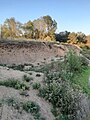
 View from the water inlet over the pool |
||
| location | Weiterstadt , Darmstadt-Dieburg district , Hesse , Germany | |
| surface | 8.03 ha | |
| Identifier | 1432007 | |
| WDPA ID | 82114 | |
| Natura 2000 ID | DE6117311 | |
| FFH area | 8.0302 ha | |
| Geographical location | 49 ° 53 ' N , 8 ° 34' E | |
|
||
| Sea level | from 99 m to 100 m ( ø 99.5 m) | |
| Setup date | July 18, 1983 | |
| particularities | added September 20, 1993 | |

The Löserbecken of Weiterstadt is a nature reserve (NSG identification 1432007) in the district of Weiterstadt in the Darmstadt-Dieburg district in southern Hesse . It was designated by ordinance of July 18, 1983 with an area of 8.03 hectares and the delimitations were amended on September 20, 1993. Since 2008 it has also been part of the European nature conservation network as the Natura 2000 area "NSG Löserbecken von Weiterstadt" (FFH area 6117-311).
geography
The Löserbecken is an artificially created still water and a forest and meadow area on the southwest edge of Weiterstadt. Originally it is an earlier sand pit from the 1970s, at the bottom of which wet zones and pools have formed, which are largely fed by rainwater . In terms of natural space, the area is part of the Griesheim-Weiterstädter Sands, which in turn represents a sub-unit of the Upper Rhine Plain . Climatically, this location is characterized by low rainfall (less than 600 mm per year) and a generally mild climate.
Immediately to the north is the Weiterstadt correctional facility , the construction of which in 1987 and the demolition and subsequent reconstruction of the area in 1990 had a major impact on the area. For example, to compensate for the necessary interventions in the course of the new building, additional amphibian pools were created. In the east and south-east there are former clarifiers, which are no longer in use today.
Protection purpose
By placing it under protection, the wet biotopes on the pit floor, the dry, warm open grass corridors and flowering ruderal corridors in the area of the pit embankments as well as the interspersed bushes and woody areas in the surrounding area are to be preserved.
Flora and fauna
The plant communities of the area have gone through various stages of succession since the end of the economic use of the Loser Basin . For example, there are populations of pines , willows , locust trees and poplars , and hedges and bushes have been planted to delimit agricultural areas in the north and west.
The looser basin is of particular importance for amphibian protection; among other protected species such as garlic toad , agile frog and toad also comes here crested newt before which in FFH called Annex II as a "species of Community interest". The reptiles are represented in the area by the sand lizard . Furthermore, here incubates the marsh harrier .

NSG Löserbecken of Weiterstadt (2020)
Sand wall with nest holes (2020)

Still waters (2020)

NSG Löserbecken of Weiterstadt (2020)


See also
Individual evidence
- ↑ a b Ordinance on the “Löserbecken von Weiterstadt” nature reserve of July 18, 1983. PDF. State Gazette for the State of Hesse, issue No. 31/1983, p. 1583, No. 902, accessed on July 15, 2020 .
- ↑ Map of the nature reserve. natureg.hessen.de, accessed on July 15, 2020 .
- ↑ a b c d e f Management plan for the FFH area "NSG Löserbecken von Weiterstadt". PDF. Darmstadt Regional Council, June 28, 2013, accessed on July 15, 2020 .
Web links

Altneckarlachen from Alsbach, Hähnlein and Bickenbach | At the Kleewoog of Graefenhausen | On the sand between Hergershausen and Altheim | Brackenbruch near Hergershausen | Broken meadows of Dorndiel | Buchertsgräben near Schlierbach | The great Hörmes (Dieburg) | The little jellyfish from Hergershausen | Faulbruch near Erzhausen | Faulbruch von Munster | Foal pasture from Dieburg | Forstberg von Ueberau | Fuchswiese near Stettbach | Griesheimer Bruch | Big and small break near Roßdorf | Hegbachaue near Messel | Herrnberg von Groß-Umstadt | In the Dulbaum near Alsbach | Sand-lime pine forest near Bickenbach, Pfungstadt and Seeheim-Jugenheim | Loser basin from Weiterstadt | Neuwiese by Messel | Pfungstädter Moor | Rallenteich from Eppertshausen | Reinheimer pond | Sandstone quarries on the Burzelberg near Mrs. Nauses | Scheelhecke von Groß -zimmer | Taubensemd from Habitzheim, Semd and Groß-Umstadt