
Avrămeşti (Harghita)
|
Avrămeşti Szentábrahám |
|||||
|
|||||
| Basic data | |||||
|---|---|---|---|---|---|
| State : |
|
||||
| Historical region : | Transylvania | ||||
| Circle : | Harghita | ||||
| Coordinates : | 46 ° 20 ' N , 25 ° 1' E | ||||
| Time zone : | EET ( UTC +2) | ||||
| Height : | 421 m | ||||
| Area : | 28.19 km² | ||||
| Residents : | 2,465 (October 20, 2011) | ||||
| Population density : | 87 inhabitants per km² | ||||
| Postal code : | 537010 | ||||
| Telephone code : | (+40) 02 66 | ||||
| License plate : | MR | ||||
| Structure and administration (as of 2016) | |||||
| Community type : | local community | ||||
| Structure : | Avrămeşti, Andreeni , Cecheşti , Firtănuş , Goagiu , Laz-Firtănuş , Laz-Șoimuş , Medişoru Mic | ||||
| Mayor : | Dezső-Szabolcs Simó ( UDMR ) | ||||
| Postal address : | Str. Principală, no. 126 loc. Avrămeşti, jud. Harghita, RO-537010 |
||||


Avrămeşti [ avrəˈmeʃtʲ ] (outdated Sîn-Avram or Avram ; Hungarian Szentábrahám ) is a municipality in Harghita County , in the Transylvania region in Romania .
Geographical location

The municipality of Avrămeşti is located in the Subcarpathian Mountains (Subcarpați) - a foreland of the Eastern Carpathians - in the historical region of Szeklerland in the west of Harghita County. On the Geoagiu brook , a right tributary of the Târnava Mare (Great Kokel) and the district road (drum județean) DJ 136, the place Avrămeşti is six kilometers north of the small town of Cristuru Secuiesc (Szekler's Cross) and about 85 kilometers west of the district capital Miercurea Ciuc (Szeklerburg) away.
The nearest train station is in Cristuru Secuiesc on the Sighișoara – Odorheiu Secuiesc railway line .
history
The place Avrămeşti, mostly inhabited by Szeklern people, was first mentioned in a document in 1334. On the area of Avrămeşti, known by the locals as Valea Cămăşii ( Ingvölgy in Hungarian ), a settlement of the Bronze Age was assigned according to archaeological finds . To the east of the village, at Dealul Jidovilor (Zsidóvölgy) , the remains of a medieval castle can be seen. The assumptions of B. Orbán from 1896 that in the incorporated village of Firtănuş (Firtosmartonos) near Vârful lui Iştoc (Istók tetöje) and near Vârful Bárca (Bárca tetöje) there was a Roman auxiliary troop camp , has not been confirmed. In unincorporated village Goagiu (Hungarian Gagy ) an archaeological find was the Neolithic are assigned, the Fund Orbán's a fire pit in the middle of a mound at Valea Iarului (Járpataka) , also no age could be assigned.
At the time of the Kingdom of Hungary Avrămeşti belonged to the chair district Székelykeresztúr in the Udvarhely County ( Romanian Comitatul Odorhei ), then to the historical Odorhei district and from 1950 to the present Harghita district.
population
The population of today's Avrămeşti municipality developed as follows:
| census | Ethnic composition | ||||
|---|---|---|---|---|---|
| year | population | Romanians | Hungary | German | other |
| 1850 | 2,404 | 6th | 2,398 | - | - |
| 1956 | 3,062 | 10 | 3,028 | 3 | 21st |
| 2002 | 2,517 | 14th | 2,459 | - | 44 |
| 2011 | 2,465 | 17th | 2,105 | - | 343 |
Since 1850, the highest number of inhabitants and that of the Magyars was determined in the area of today's Avrămeşti municipality. The highest number of Romanians (22) was registered in 1977, German speakers (13) in 1880 and Roma (278) in 2011.
Attractions
- In Avrămeşti the Unitarian Church was built between 1803 and 1811. According to the register of historical monuments of the Ministry of Culture and National Heritage (Ministerul Culturii și Patrimoniului Național) this is a listed building.
- Also worth seeing are the Reformed churches in the incorporated villages of Cecheşti (Csekefalva) and Goagiu, and the Unitarian churches in Cecheşti built in 1833, built in Firtănuş in 1906 and those in Goagiu built in 1901.
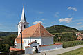
Unitarian Church in Avrămeşti

... and in Firtănuș


Web links
Individual evidence
- ↑ 2011 census in Romania ( MS Excel ; 1.3 MB).
- ↑ Heinz Heltmann, Gustav Servatius (Ed.): Travel Guide Siebenbürgen . Kraft, Würzburg 1993, ISBN 3-8083-2019-2 , p. 517 .
- ^ Institute Of Archeology - Avrămești , accessed on July 16, 2020 (Romanian).
- ↑ Institute Of Archeology - Firtanus , accessed on 16 July 2020 (Romanian).
- ↑ Institute Of Archeology - Goagiu , accessed on 16 July 2020 (Romanian).
- ↑ Censuses 1850–2002, last updated November 2, 2008 (PDF; 1 MB; Hungarian).
- ↑ Information on the Unitarian Church in Avrămeşti at biserici.org, accessed on July 16, 2020 (Romanian).
- ↑ List of historical monuments of the Romanian Ministry of Culture , updated 2015 (PDF; 12.7 MB; Romanian).
- ↑ Information on the Reformed Church in Cecheşti at biserici.org, accessed on July 16, 2020 (Romanian).
- ↑ Information on the Reformed Church in Goagiu at biserici.org, accessed on July 16, 2020 (Romanian).
- ↑ Information on the Unitarian Church in Cechești at biserici.org, accessed on July 16, 2020 (Romanian).
- ↑ Information on the Unitarian Church in Firtănuș at biserici.org, accessed on July 16, 2020 (Romanian).
- ↑ Information on the Unitarian Church in Goagiu at biserici.org, accessed on July 16, 2020 (Romanian).
Atid | Avrămeşti | Bilbor | Brădeşti | Căpâlnița | Cârța | Ciceu | Ciucsângeorgiu | Ciumani | Corbu | Corundum | Cozmeni | Dăneşti | Dârjiu | Dealu | Ditrău | Feliceni | Frumoasa | Gălăuțaș | Joseni | Lăzarea | Leliceni | Lueta | Lunca de Jos | Lunca de Sus | Lupeni | Mădăraș | Mărtiniș | Merești | Mihăileni | Mugeni | Ocland | Păuleni-Ciuc | Plăieșii de Jos | Porumbeni | Praid | Racu | Remetea | Săcel | Sâncrăieni | Sândominic | Sânmartin | Sânsimion | Sântimbru | Sărmaș | Satu Mare | Secuieni | Siculeni | Șimoneşti | Subcetate | Suseni | Tomeşti | Tulgheș | Tuşnad | Ulieș | Vărșag | Voșlăbeni | Zetea