Bani (Pangasinan)
|
Municipality of Bani Bayan ng Bani |
||
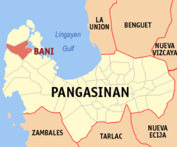
| Location of Bani in the Pangasinan Province | ||
|---|---|---|

|
||
| Basic data | ||
| Region : | Ilocos region | |
| Province : | Pangasinan | |
| Barangays : | 27 | |
| District: | 1. District of Pangasinan | |
| PSGC : | 015508000 | |
| Income class : | 3rd income bracket | |
| Households : | 8910 May 1, 2000 census
|
|
| Population : | 50,306 August 1, 2015 census
|
|
| Population density : | 261.4 inhabitants per km² | |
| Area : | 192.43 km² | |
| Coordinates : | 16 ° 11 ′ N , 119 ° 52 ′ E | |
| Postal code : | 2407 | |
| Area code : | +63 75 | |
| Mayor : | Marcelo E. Navarro Jr. | |
| Website: | www.bani.gov.ph | |
| Geographical location in the Philippines | ||
|
|
||
Bani is a municipality in the Philippine province of Pangasinan and borders the Gulf of Lingayen to the east and the rest of the South China Sea to the west .
15 different languages are spoken in Bani, with the majority of the population speaking Ilokano . The terrain is very flat and reaches up to 130 meters above sea level.
Bani is divided into the following 27 barangays :
|
|
