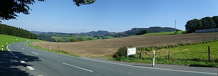
Bastenberg (Ramsbeck)
| Bastenberg | ||
|---|---|---|
| height | 745.1 m above sea level NHN | |
| location | North Rhine-Westphalia , Germany | |
| Mountains | Hochsauerländer Schluchtgebirge , Rothaargebirge | |
| Dominance | 9.6 km → Hunau | |
| Notch height | 248 m ↓ west of Westernbödefeld | |
| Coordinates | 51 ° 18 '4 " N , 8 ° 23' 2" E | |
|
|
||
The 745.1 m above sea level. NHN high Bastenberg northwest of Ramsbeck is the highest of the Ramsbeck heights in the western part of the Hochsauerländer Schluchtgebirge , the northernmost part of the Rothaargebirge . It is the main and most northerly Rothaargebirge summit of the ridge, which stretches from the 818.5 m high Hunau in the south between the Nierbach and Valme streams to the north to the Ruhr . The Bastenberg is one of the most dominant and prominent mountains in the Rothaargebirge and North Rhine-Westphalia .
geography
location
The Bastenberg is located in the district of Ramsbeck in the area of the municipality of Bestwig in the Hochsauerlandkreis . Bestwig in the north-north-east is 6.8 km as the crow flies, Meschede in the north-west 9 km, Eslohe in the west -south- west 15 km, Schmallenberg in the south-south-west 17 km, Winterberg in the south-east 15 km and Olsberg in the north-east 9 km. The cleared Bödefelder Mulde in the south, where the Ramsbeck heights flatten until the height increases again to the Hunau, is about 5 km ( Westernbödefeld ) to 6 km ( Bödefeld ) away, to Remblinghausen in the Eslohe-Reister valley in the west it is about 5 , 5 km.
Natural allocation
The natural area of the Bastenberg is assigned as follows:
-
(to 33 Süderbergland )
-
(to 333 Rothaar Mountains )
-
(to 333.8 Hochsauerland Gorge Mountains )
- 333.82 Ramsbeck ridge and gorges
-
(to 333.8 Hochsauerland Gorge Mountains )
-
(to 333 Rothaar Mountains )
The Ramsbeck Ridge are separated from each other by the deepened valleys of the tributaries of the same, which run from the Hunau massif northwards to the Oberruhrgesenke of the Ruhr . All of the main mountains in the north are, from west to east (dividing rivers in brackets):
- ( Nierbach )
- Bastenberg (745.1 m)
- ( Valme )
- Stüppel (731.5 m)
- ( Elpe )
- Wiedegge (732.5 m)
- ( Negro )
- Heidkopf (715.3 m)
Dominance, prominence and relief energy
The absolute height of the Bastenberg does not quite match the mountains of the Langenberg natural area (up to 843 m), the Kahler Asten (842 m), the Hunau (818.5 m), the Ziegenhelle (816 m) and the highest mountains of the Hohe Side (up to 792 m) and the Rothaar (up to 768 m), but in terms of independence it lies directly behind the Langenberg .
Hunau, exactly 10 km to the south, only reaches its height at a distance of 9.6 km. With this dominance , the Bastenberg lies behind the Asten, the Härdler in the Rothaar and the lower compass in the extreme southwest of the mountains, but clearly ahead of Hunau, Ziegenhelle, Reetsberg and Bollerberg .
If you want to reach the next higher point on the Hunau from the summit of the Bastenberg, you have to descend immediately west of Westernbödefeld to about 497 m, which gives the Bastenberg a prominence of 248 m, which is well above that of all other mountains mentioned with the exception of the Langenberg.
The Brabecke flows east below the Bastenberg at an altitude of almost 375 m into the Valme . At just 530 horizontal meters, the Bastenberg has already risen by 200 meters and at 1040 meters by 300 meters; One and a half kilometers from the mouth, the Bastenberg has reached its entire 370 meter difference in altitude. Such a large, small-scale relief energy is extremely rare in the Rothaar Mountains and is more typical for higher low mountain ranges such as the Black Forest or the Harz Mountains .
Mining
The Bastenberg is located in the former Ramsbeck mining area. The Venetian gallery was built in the Middle Ages, and Pingen and other tunnels are evidence of earlier mining. The smoke gas fireplace on the Bastenberg dates from the 19th century and is now a memorial that is clearly visible from the valley.
Sources and footnotes
- ↑ Map services of the Federal Agency for Nature Conservation ( information )
- ↑ a b c d Topographical Information Management, Cologne District Government, Department GEObasis NRW ( information )
- ↑ Martin Bürgener: Geographical Land Survey: The natural spatial units on sheet 111 Arolsen. Federal Institute for Regional Studies, Bad Godesberg 1963. → Online map (PDF; 4.1 MB)
- ↑ Friends of the Sauerland Visitor Mine Bestwig-Ramsbeck: Mining archeology on the Bastenberg .

