
Birch trees (Bayreuth)


Birken is a district of Bayreuth .
Surname
The name of the district can be traced back to the "Acker auf den Pircken", which was still undeveloped at the time and was first mentioned in a document in 1485. It is preferably used with article in the singular, but also occurs in the plural. One can therefore be “in the birches” as well as “in the birches”, but in no way “in the birches”.
location


The district of Birken borders in the north on the underground canalized Sendelbach under Universitätsstrasse and Wittelsbacherring on the historic city center . In the east and south-east the former railway line to Hollfeld and Thurnau (today the footpath and bike path) forms the border, in the south it has partially shifted to the allotment garden colonies Exerzierplatz and Schwedenbrücke due to the construction of the Quellhöfe residential area in the 1960s. To the west, the Aubach and the Röhrensee border the district.
It lies on the slope and on the plateau of a hill between the valleys of Sendel- and Aubach, which surround them almost in a ring. At 361 meters, the highest point is in the area of Friedenstraße in the Quellhöfe district, the lowest at 341 meters at the confluence of the rivers mentioned.
The two main axes of the district are in northeast-southwest direction Birkenstrasse (northern approach) and Hegelstrasse, which runs at right angles to it (western approach). The previous connection via the Quellhöfe street is closed to motor vehicles. Access from the university premises via Wichernstrasse is reserved for cyclists and public buses.
History and description
Until 1933

After the Oberer Quellhof (from around 1495), Birken Castle is the second oldest building in the district. A first building at this point can be identified from around 1507. In 1684, Margrave Christian Ernst von Brandenburg-Bayreuth gave the farm to his court marshal Hans Wilhelm von Erffa . Between 1686 and 1692 he had the existing house torn down and replaced with a new building. This building, also known as the manor house , still exists, but the Birken estate next to it has disappeared. In May 1952 it was decided to abandon it, and demolition began in April 1954. After the site was used as a nursery, the semicircular residential complex Schlosshof Birken was built there in 1978.
On the eastern edge of the district, the Frankengut can be traced back to before 1800. The name of the farm (later “Großer Lautner”) can be traced back to the first owner, Susanna Margarete Franckin, widow of a “councilor”. In 1846 a second farm (Unteres Frankengut or “Kleiner Lautner”) and in 1906 a third (Spitzbarthhof) was built. From 1980, the ensemble had to give way to Emil-Warburg-Weg and the adjoining student dormitories in the course of building the university.
There was no further development until 1896. At that time, the garrison hospital was built on Lazarettstrasse, today's Hegelstrasse, in whose buildings the Center Bavaria Family and Social Affairs, the former pension office, is located. In the first years of the 20th century, a few individual buildings were built there - and on Birkenstrasse on both sides of the Sendelbach.
Several fish ponds existed well into the 20th century, the most important of which were fed by the Sendelbach. The Lange Weiher was located in the area of today's Kreuzsteinbad and became part of the military swimming school in 1883. Downstream of the stream, east of Birkenstrasse, was the Plassenburger Weiher, also known as the Plassenweiher, which was closed by the 1950s at the latest.
SA settlement


In 1936, the planned development of the area was tackled with the "SA settlement Birken". Initially north of Hegelstrasse (then “Strasse der SA”), between Birkenstrasse and Schellingstrasse, and from 1938 also southwest of it, two diagonally opposite residential areas with semi-detached houses were built. On Hegelstrasse, they were supplemented by a number of significantly larger, isolated houses. Beneficiaries of the residential estate, which had already been applied for by the "SA-Standarte 77 Oberfranken" in 1934 on the basis of the Siebert program, an extraordinary Bavarian housing program, should be "deserved" SA men. The Stein'sche Foundation had to provide the building site. The owners of the buildings with living space of 120 to 140 square meters were employed and civil servants from the middle class.
According to plans by the architect Hans Reissinger, a large part of the development in the area between the Hofgarten , Birkenstrasse, Hegelstrasse and Ludwig-Thoma-Strasse as far as Dammwäldchen should be demolished and there, analogous to the plans in Berlin ("Germania") and Linz , the bombastic "Gauforum Bayreuth" arise. For this reason, a carpentry business was relocated from Jean-Paul-Straße to the beginning of the street to the parade ground. Located on the hillside, the buildings had to be kept low in order not to obstruct the “Führer” from seeing the Sophienberg. The carpenter's workshop, which was built on the grounds of the Stein'schen Foundation under heritable building rights, represented the first development on what would later become Eichendorffring. Today, the Alexander von Humboldt House is the university's guest house .
After 1945
In 1953, south of the railway line, on the site of the former parade ground, the outsourced Birkengut of the Stein'schen Foundation was built. It had the first deep free stall in Bavaria for pigs, cattle and young cattle. The farm building and the stables burned down in 1955 and were rebuilt in the same year. After the university was built on the site, the house was initially used by the Geological Institute, but was finally removed in 1994 after another fire.
From 1949 to the end of the 1960s, the siding to the municipal gasworks at the beginning of Birkenstrasse, which was shut down after being connected to the long-distance gas supply at the beginning of March 1965 and dismantled in October of that year , branched off in a narrow curve at the level of the Frankengut . Between 1951 and 1969 the lattice mast of the Bayreuth transmitter stood at this point on the Frankengut .
The post-war development of the residential area took place in several phases; central supply facilities were initially not planned. The building plans were largely uniform until the 1960s, with multi-family houses, semi-detached houses and single buildings being built. From then on, terraced houses were predominantly built, with larger blocks of flats on the northern Eichendorffring as well.
With the establishment of the university adjacent to the south in 1974, the remaining agricultural land of the Franconian estate was built on. There is also the Emil-Warburg-Weg pedestrian zone with student dormitories and a small Catholic church. The student village of Birken, initially with 352 student apartments, was completed in the 1993/94 winter semester. Opposite the historic “swimming school”, the Kreuzsteinbad open-air pool has existed since 1964 with a wave pool, a 10-meter diving tower and a high water slide.
Quellhöfe

The Quellenhöfe residential area was created in the 1960s as a “quarter within a quarter”. The name can be traced back to the historic spring courtyards, of which a water pipe was laid in the city center as early as 1611 to supply four wells. The Oberer Quellhof estate can be traced back to 1645. The Untere Quellhof in the Aubachsenke, also called “Fischhaus” in the 17th century, was demolished in 1937 for reasons of drinking water protection.
1903 comes, the listed "infirmary" that the notorious brothel owner Anna scratch as House of Pleasure was built. Baron Albrecht von Reitzenstein, the last farmer on the Oberer Quellhof, prevented such use of the building. In 1906 the owner was forced to sell the building at a lower price to the Ida Schmidt'sche Infirmary Foundation. Today it is used as a residential building.
In 1961, a Protestant parish hall was built on Friedenstrasse and the Friedenskirche was consecrated in 1969. Its 21 meter high tower has four bells.
Parade ground
From 1897 to 1945, the parade ground was located on most of the area that is now the Quellhöfe district, the adjacent allotment garden areas, the corridors to the south and east of it and the university campus . It was needed after the barracks were moved to the south of the city (from 1879). The access to this closed military area was at the level of today's property at Friedenstrasse 7. The city administration acquired the site in 1896 and leased it to the military administration before they acquired the entire area in 1908.
The Aubach has largely moved to this area in a closed channel. Civilians were only allowed to enter the site to a limited extent, for example during parades and air shows. The first Bayreuth flight day took place in 1912 on the parade ground. During the First World War , a barrack camp for 1200 prisoners of war was built there .
Allotments
The Schwedenbrücke allotment gardens were built on the western edge of the parade ground as early as 1920. To the east, the parade ground was added in 1946 on the former military site. The zoning plan of 1959 provides for the terrain to be guaranteed this status in the long term.
Infrastructure

The district has lost its commercial operations that were established in the 20th century, the Riedel joinery in Eichendorffring and the Voigt nursery on the grounds of the estate (still existing as a shop). Of the four grocery stores from the 1960s, only one still exists, and the bakery, dairy and haberdashery were also given up. With the construction of the university, an infrastructure developed on Emil-Warburg-Weg that is primarily geared towards student needs (gastronomy, bookstore, travel agency).
A kindergarten has existed in the Protestant parish hall since 1962, others were added later. There is a primary school on Emil-Warburg-Weg as a branch of the Luitpold School. Its predecessor was initially housed in two pavilions on the way from Eichendorffring to Kreuzsteinbad since 1965.
On December 16, 1964, the Mühlhofer-Stift retirement and nursing home was inaugurated. Its predecessor was established in 1951 as a facility by the Rummelsberger Anstalten in a former barracks building on Ludwig-Thoma-Strasse.
Others

There is a transformer station opposite the house at Hegelstrasse 29 .
The Wilhelm Leuschner Center has had its headquarters at Herderstrasse 29 since 2012. The social democratic politician Wilhelm Leuschner was part of the resistance against National Socialism . Two months after the failed attack on Hitler , he was executed in Berlin in 1944. His birthplace, a memorial since 2003, is not far from it in the Moritzhöfen district .
One of the most sensational murders of the West German post-war period took place in a villa on Hegelstrasse . In March 1964 there is a slew First Lieutenant of the US Army 's 18-year-old German girlfriend. He dismembered the dead woman in the bathtub and "disposed of" the body parts at various parking lots on the motorway to Nuremberg . The building at the confluence with Schellingstrasse was later demolished.
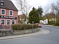
Steep stretch on the Birkenberg

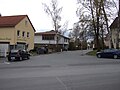
View over the Birkenstrasse to the Bindlacher Berg
Upper Eichendorffring with the university guest house


Web links
literature
- Kurt Herterich : Southern Bayreuth . Ellwanger, Bayreuth 1996, ISBN 978-3-925361-26-5 .
- Kurt Herterich: In the south-east of Bayreuth . Ellwanger, Bayreuth 2000, ISBN 3-925361-38-3 .
- Herbert Popp: Bayreuth - rediscovered . Ellwanger, Bayreuth 2007, ISBN 978-3-925361-60-9 .
Individual evidence
- ↑ Bayreuth City Archives: Hospital bills
- ↑ Repair of the bridge at the Plassenburger Weiher "bei der Birken" , document from the 18th century in the Bamberg State Archives
- ^ Topographic map of Bayreuth at topographic-map.com, accessed on August 8, 2015
- ↑ Kurt Herterich: Südliches Bayreuth, p. 84
- ↑ Kurt Herterich: In the southeast of Bayreuth, p. 97 ff
- ↑ Flyer for the exhibition Finsterer Weiher and Green Sea of the Historisches Museum Bayreuth
- ↑ http://www.historisches-lexikon-bayerns.de/artikel/artikel_44784
- ^ Herbert Popp: Bayreuth - newly discovered, p. 323
- ↑ Herbert Popp: Bayreuth - newly discovered, p. 106 ff
- ↑ Archive link ( Memento of the original from January 6, 2012 in the Internet Archive ) Info: The archive link was inserted automatically and has not yet been checked. Please check the original and archive link according to the instructions and then remove this notice.
- ↑ 25 years ago in: Nordbayerischer Kurier of November 5, 2019, p. 10.
- ↑ Kurt Herterich: Im southeastern Bayreuth , p. 82.
- ^ End of Bayreuth gas production in: Nordbayerischer Kurier of March 2, 2015, p. 10.
- ↑ Bernd Mayer: Bayreuth in the twentieth century , p. 111 u. 118 ..
- ↑ Bernd Mayer: Bayreuth in the twentieth century , p. 102.
- ↑ 25 years ago in: Nordbayerischer Kurier of September 11, 2018, p. 10.
- ↑ Kurt Herterich: Südliches Bayreuth , p. 89 ff.
- ↑ 50 years ago: Topping-out ceremony at Friedenskirche in: Nordbayerischer Kurier from 15./16. December 2018, p. 14.
- ↑ Kurt Herterich: Im southeastern Bayreuth, p. 94
- ^ Herbert Popp: Bayreuth - newly discovered, pp. 328/329
- ↑ Bernd Mayer: Bayreuth in the twentieth century , p. 31.
- ^ Herbert Popp: Bayreuth - newly discovered, p. 332
- ↑ Kurt Herterich: Im southeastern Bayreuth , p. 86
- ↑ 50 years ago in: Nordbayerischer Kurier of July 3, 2015, p. 12
- ↑ Kurt Herterich: Südliches Bayreuth , p. 107
- ↑ 25 years ago. Child survives 20,000 volts in: Nordbayerischer Kurier from January 9, 2020, p. 10.
- ↑ 50 years ago in: Nordbayerischer Kurier of September 17, 2015, p. 12
- ^ The bloody deed of Bayreuth at zeit.de (archive) of October 21, 1966, accessed on September 17, 2015

Aichig | Old town * | Peasant green | Farms | Bayreuth ( historic city center ) | Birch trees * | Floor mill | Castle * | Bürgerreuth * ( Green Hill ) | Colmdorf | Destuben | Dörnhof | Dürschnitz * | Eichelberg | Hermitage | Hermit Court | Frankengut | Friedrichsthal | Prosecution | Garden City * | Vulture's Nest | Geigenreuth | Bell * | Grunau | Grunauermühle | Green tree * | Hammerstatt * | Heinersberg | Hermannshof | Hollow mill | Hölzleinsmühle | Hornsröth | Hussengut | Juchhöh | Karolinenhöhe | Karolinenreuth | Barracks district * | Cross * | Cross stone | Krodelsberg | Krugshof | Laimbach | Laineck | Latvians | Tan | Meyernberg | Meyernreuth | Moss hill | Moritzhöfen * | Mosing * | New home * | New way * | Upper Röth | Oberkonnersreuth | Oberobsang | Oberpreuschwitz | Oberthiergarten | Opelsgut | Oschenberg | Pfaffenfleck | Plantation | Powder mill | Püttelshof | Riedelsgut | Rödensdorf | Rodersberg | Rollwenzelei | Römerleithen | Römersberg | Red Hill * | Saas | St. Georgen * | St. Johannis | Shooting house | Schlehenberg | Schlehenmühle | Schupfenschlag | Seulbitz | Worry Flee | Spinning Quarter | Southwest city center * | Devil's Trench | Thiergarten | Lower Röth | Unterpreuschwitz | Fulling Mill | Weiherhaus | Wendelhöfen | Meadows | Wolfsbach | Wunau | Wondrous good
* none of the official 74 districts
Coordinates: 49 ° 55 ′ 56.1 ″ N , 11 ° 34 ′ 52.7 ″ E