Bradfield Highway
| Bradfield Highway | |
|---|---|

|
|
| Basic data | |
| Operator: | Roads and Maritime Services |
| Start of the street: |
|
| End of street: |
Pacific Highway North Sydney ( NSW ) ( 33 ° 51 ′ S , 151 ° 13 ′ E ) |
| Overall length: | 2.4 km |
|
States : |
|
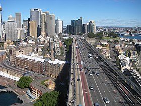
| Bradfield Highway, southwest end | |
The Bradfield Highway is an urban highway in the center of Sydney in the east of the Australian state of New South Wales . It connects the Cahill Expressway and the Western Distributor in Sydney city center with the Warringah Freeway in North Sydney. The Sydney Harbor Bridge is part of this highway, which is 2.4 km long and is one of the shortest in the country.
The highway was named after Dr. John Bradfield , an engineer who oversaw the tender for the construction of the bridge.
history
The Bradfield Highway opened in 1932. The Sydney Harbor Tunnel was opened in August 1992, helping to reduce traffic jams on the highway.
The marathons of the 2000 Summer Olympics were held on the Bradfield Highway .
In 2001, 159,587 vehicles were using the Bradfield Highway per day.
State of development
The Bradfield Highway occupies six lanes on the eight-lane bridge. The other two lanes belong to the Cahill Expressway, which only runs south in the area of the bridge. During rush hour, the direction of travel is changed on three of these lanes, so that 2–5 lanes run north and the others go south. Outside of peak hours, four lanes run north and two south. The direction of travel is displayed electronically controlled above each strip. The lanes are numbered from west to east. Until 1990 it was also possible to reverse the direction of travel of the 6th lane, but this is no longer possible because of the connection to the tunnel.
Crossings and junctions
|
Bradfield Highway |
|||
| Connections to the north | Distance to Brisbane (km) |
Distance to Sydney CBD (km) |
Connections to the south |
|
End of Bradfield Highway further than Warringah Freeway to North Sydney / Newcastle / Brisbane |
934 | 3 |
Start of the Bradfield Highway from the Warringah Freeway |
| TOLL BOARD | |||
| SYDNEY HARBOR BRIDGE | 935 | 2 | SYDNEY HARBOR BRIDGE |
|
Start of Bradfield Highway from the Western distributor |
936.5 | 0.5 |
Wollongong , Canberra Cahill Expressway |
|
At the end of the Bradfield Highway, continued as a Western distributor to Ashfield / Parramatta |
|||
source
- Steve Parish: Australian Touring Atlas . Steve Parish Publishing. Archerfield QLD 2007, ISBN 978-1-74193-232-4 , pp. 21 + 22.

