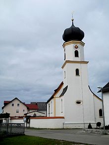
Breitenhill
|
Breitenhill
Altmannstein market
Coordinates: 48 ° 55 ′ 45 ″ N , 11 ° 32 ′ 5 ″ E
|
||
|---|---|---|
| Height : | 524 (520-524) m | |
| Residents : | 57 (March 15, 2007) | |
| Postal code : | 93336 | |
| Area code : | 08468 | |
|
Location of Breitenhill in Bavaria |
||
Breitenhill is a church village and part of the Altmannstein market in the Upper Bavarian district of Eichstätt .
location
The place lies on the plateau of the southern Franconian Jura east of Denkendorf and the federal highway 9 and west of the federal highway 299. From Pondorf a local road leads to Megamnnsdorf and further to Breitenhill; there is also a local road from Winden to Breitenhill.
Place name interpretation
Breitenhill is derived from Prettenhill . The ending -hill comes from Hüll , which means that a wide Hüll used to exist here . Karl Kugler rejects this interpretation and interprets the place name as a village on the toad hull from the Old High German “preita”, “the toad.” Because of the scarcity of water in the Jura, a “wide hull” is hardly to be expected.
history
Prettenhill was first mentioned in 1136/37 in the founding document of the Regensburg Bishop Heinrich I for the Augustinian Canons Schamhaupten . In 1554 the shabby provost Schamhaupten and thus Breitenhill came under secular administration; In 1606/09, under the Bavarian Duke Maximilian I, with the approval of Pope Paul V, the University of Ingolstadt received the provost's income.
On April 1, 1949, Breitenhill was incorporated with the neighboring village of Megmannsdorf and the village of Winden into the municipality of Winden in the then Upper Palatinate district of Riedenburg . From 1954 to 1966, Breitenhill was part of the Winden school district. As part of the regional reform in Bavaria , the municipality of Winden and thus Breitenhill was incorporated into the Altmannstein market on July 1, 1977 . Thus Breitenhill came from the Upper Palatinate district of Riedenburg, which was dissolved at the same time, to the formerly Middle Franconian, now Upper Bavarian district of Eichstätt.
In 1961 the village had 16 residential buildings. In 1983 there were two full-time agricultural businesses and ten part-time businesses, an inn, a retail shop and a craft business in the village.
Population development
- 1860: 107
- 1912: 135
- 1933: 112
- 1939: 98
- 1961: 101
- 1972: 81
- 1983: 72
- 2007: 57
Catholic branch church Heilig Kreuz
A chapel in Breitenhill is mentioned as early as 1136/37. The local church, a branch church of Pondorf , was built in the 18th century and expanded to the east in 1901. The tower, crowned with an onion , dates from 1906. The church has a baroque high altar with a wooden statue of the Virgin from the 2nd half of the 15th century and heavily reworked. A soul dungeon contains walled-in human skeletal remains.
Others
The 170 or 155 km long Via Raetica cycle path leads through Breitenhill, following the historic Via Raetia .
The German Limes Cycle Path also runs through the village . This follows the Upper German-Raetian Limes over 818 km from Bad Hönningen on the Rhine to Regensburg on the Danube .
The “miracle beech” at Breitenhill is two beeches that have grown together through a branch.
literature
- Franz Fersch: Chronicle of the village and parish Pondorf , Schierling [circa 1973] [Ex. in the Bischöfl. Central Archive Regensburg].
- The Eichstätter area past and present . Eichstätt 1984, p. 173.
- Friedrich Hermann Hofmann and Felix Mader (arrangement): The art monuments of Upper Palatinate and Regensburg. District Office Beilngries II , Munich 1908 (reprint 1982), p. 38.
- Paulus Eckerle: Building in the Altmühltal. Stone, roof, knee stick. Gaimersheim. Titting. Breitenhill. Mörnsheim. Arnsberg. Buxheim etc. Kipfenberg Hercynia, Ansbach 1991.
Individual evidence
- ^ Karl Kugler: Explanation of a thousand place names of the Altmühlalp and its surroundings. One try. Eichstätt 1873: Verlag der Krüll'schen Buchhandlung, p. 129
- ^ Collective sheet of the historical association Eichstätt 92/93 (1999/2000), p. 55; Fersch, p. 8
- ↑ Collective sheet of the historical association Eichstätt 92/93 (1999/2000), p. 58
- ^ Wilhelm Volkert (ed.): Handbook of Bavarian offices, communities and courts 1799–1980 . CH Beck, Munich 1983, ISBN 3-406-09669-7 , p. 557 .
- ↑ Fersch, p. 8
- ^ Federal Statistical Office (ed.): Historical municipality directory for the Federal Republic of Germany. Name, border and key number changes in municipalities, counties and administrative districts from May 27, 1970 to December 31, 1982 . W. Kohlhammer, Stuttgart / Mainz 1983, ISBN 3-17-003263-1 , p. 598 .
- ↑ Fersch, p. 10
- ↑ a b Bavarian State Statistical Office (ed.): Official city directory for Bavaria, territorial status on October 1, 1964 with statistical information from the 1961 census . Issue 260 of the articles on Bavaria's statistics. Munich 1964, DNB 453660959 , Section II, Sp. 602 ( digitized version ).
- ↑ a b c d e The Eichstätter Room, p. 173
- ^ Collective sheet of the Eichstätt Historical Association 92/93 (1999/2000), p. 55
- ↑ Fersch, p. 8
- ↑ Hofmann / Mader, p. 38
- ↑ Donaukurier Ingolstadt from August 30, 2011


