
Glauburg Castle
| Glauburg Castle | ||
|---|---|---|
 Ruin of a medieval castle building on the Glauberg |
||
| Creation time : | Medieval | |
| Castle type : | Hilltop castle | |
| Conservation status: | Ruin of a castle building | |
| Construction: | Quarry stone | |
| Place: | Glauburg - Glauberg | |
| Geographical location | 50 ° 18 ′ 41 ″ N , 9 ° 0 ′ 53 ″ E | |
| Height: | 276 m above sea level NN | |
|
||

The Glauburg Castle is the ruin of a hilltop castle on a basal ridge 276 m above sea level. NN of the Glauberg southeast of the community Glauburg in the Wetteraukreis in Hesse .
history
After early colonization of the Glauberg, it carried a Franconian large castle in the 7th to 9th centuries , which was incorporated into the Staufer castle system of the Wetterau in the 12th and 13th centuries . A tower-like castle building was erected on the edge of the wall fortifications, whose quarry stone ground floor with Romanesque archway is still preserved. The remains of the foundations of medieval houses on the northern edge of the plateau, which is populated over the entire area , also date from this time . The Glauburg patrician family from Frankfurt had their headquarters here. Document mentions of the Glauburg family, the Lords of Düdelsheim and other heirs have been documented since 1247. The destruction of the castle and with it the end of the settlement of the Glauberg probably already took place in 1256.
The castle home from the plateau surrounding defensive wall of view

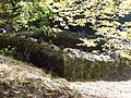
Interior of the simple castle house.


investment
Most of the buildings reconstructed or uncovered on the Glauberg plateau are part of the medieval castle complex. This includes some cellars and buildings, most of which were added to the inside of the ring wall. On the northern side of the defensive wall there is a complete row of houses with an entrance from the inside of the plateau. The single foundations are in the east and east of the southern gate system. In the south, the foundation walls of a gate ( Enzheimer gate ) have been reconstructed. To the east there is a cistern system that was excavated about five meters deep and served as a (further) rain collector, similar to the open water point on the central part of the plateau, which was already in use in the early days and for Celtic settlement.
The southern gate and access control to the Glauberg plateau: the Enzheimer gate

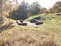
The north-western row of houses of the medieval Staufer castle settlement, which had city rights. Access from the side facing away from the defensive wall.

Another view of the row of houses

Example image of the remains of the foundations of individual houses on the eastern side of the plateau, which were provided with pens and fences.


literature
- Georg Dehio , Folkhard Cremer (edit.): Handbook of German Art Monuments - Hesse II: Administrative region of Darmstadt . Deutscher Kunstverlag, edition 1/2008
- Rudolf Knappe: Medieval castles in Hesse: 800 castles, castle ruins and castle sites, 3rd edition. Wartberg-Verlag, Gudensberg-Gleichen 2000, ISBN 3-86134-228-6 , p. 353f.
- Georg Wilhelm Sante (Hrsg.): Handbook of the historical sites of Germany . Volume 4: Hessen (= Kröner's pocket edition . Volume 274). 3rd, revised edition. Kröner, Stuttgart 1976, ISBN 3-520-27403-5 .
Individual evidence
- ↑ Hessisches Staatsarchiv Darmstadt (HStAD), documents of the former province of Upper Hesse A 3, 76/1 : The Burgmannen zu Glauburg certify a substantial donation of lands in Düdelsheim to the Arnsburg monastery (1247); Ludwig Baur: Document book of the Arnsburg monastery in the Wetterau. Publishing house of the historical association for the Grand Duchy of Hesse. Darmstadt 1851, No. 115 (1247); Friedrich Battenberg: Isenburg documents. Register of documents and copies of the princely archives in Birstein and Büdingen 974–1500. Darmstadt 1976. 3 volumes. ISBN 3-88443-210-9 , No. 71 = Fürstliches Archiv Birstein No. 2345 (around 1247).
Web links
- Glauburg Castle at burgenwelt.de
- Entry on Glauburg Castle in the private database "Alle Burgen".

Alteburg (Kohden) | Assenheim Castle | Bauernheim Castle | Berstadt Castle | Bingenheim Castle | Bisses Castle | Bracht Castle | Büdingen Castle | Burg-Graefenrode Castle | Landgraves Castle Butzbach | Solms Castle | Degenfeld's Castle | Dorheim Castle | Echzell Castle | Burgstall Enzheim | Friedberg Castle | Gedern Castle | Winning stick | Glauburg Castle | Griedel Castle | Günderrode Castle | Hardeck castle ruins | Teutonic Order Castle Kloppenheim | Konradsdorf Castle | Hofgut Leustadt | Leonhard Castle | Lindheim Castle | Lißberg Castle | Moritzstein Castle | Munzenberg Castle | Löwsche Castle (Nieder-Florstadt) | Nieder-Rosbach Castle | Nidda Castle | Ober-Mörlen Castle | Ockstadt Castle | Ortenberg Castle | Philippseck Palace | Rockenberg Castle | Södel Castle | Staden Castle | Löwsche Castle (Staden) | Stammheim Castle | Löwsche Castle (Steinfurth) | Stornfels Castle | Castle stable Ulfa | Vilbel Castle | Wölfersheim Castle | Ziegenberg Castle