
Challain-la-Potherie
| Challain-la-Potherie | ||
|---|---|---|
|
||
| region | Pays de la Loire | |
| Department | Maine-et-Loire | |
| Arrondissement | Segré | |
| Canton | Segré | |
| Community association | Anjou Bleu Community | |
| Coordinates | 47 ° 38 ′ N , 1 ° 3 ′ W | |
| height | 42-106 m | |
| surface | 47.87 km 2 | |
| Residents | 808 (January 1, 2017) | |
| Population density | 17 inhabitants / km 2 | |
| Post Code | 49440 | |
| INSEE code | 49061 | |
| Website | http://www.4c-cande.fr/listes/challain-la-potherie/ | |

Challain-la-Potherie is a French municipality with 808 inhabitants (as of January 1 2017) in Canton Segre (2015: Canton Candé ) in Arrondissement Segré in the department of Maine-et-Loire and the region Pays de la Loire . The inhabitants are called Chalainois .
geography
Challain-la-Potherie is located about 55 kilometers east-northeast of Angers in the Segréen . Challain-la-Potherie is surrounded by the neighboring communities of Ombrée d'Anjou in the north and west, Loiré in the east, Angrie in the south-east, Vallons-de-l'Erdre in the south, Le Pin in the south-west and La Chapelle-Glain in the west and south-west .
Population development
| 1962 | 1968 | 1975 | 1982 | 1990 | 1999 | 2006 | 2017 |
|---|---|---|---|---|---|---|---|
| 1,175 | 1,141 | 972 | 945 | 873 | 774 | 801 | 808 |
| Sources: Cassini and INSEE | |||||||
Attractions
See also: List of Monuments historiques in Challain-la-Potherie
- Notre-Dame church from the 18th century
- Challain-la-Potherie castle from the 19th century
- La Cour des Aulnays mansion from the 16th century
- Le Grand-Marcé mansion from the 15th / 16th centuries century
- 19th century Le Merat windmill
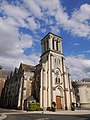
Notre-Dame church

Challain-la-Potherie Castle

La Cour des Aulnays manor house
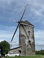
Le Merat windmill


literature
- Le Patrimoine des Communes de Maine-et-Loire . Flohic Editions, Volume 1, Paris 2001, ISBN 2-84234-117-1 , pp. 355-358.