
Chenillé-Champteussé
| Chenillé-Champteussé | ||
|---|---|---|
|
||
| region | Pays de la Loire | |
| Department | Maine-et-Loire | |
| Arrondissement | Segré | |
| Canton | Tiercé | |
| Community association | Vallées du Haut-Anjou | |
| Coordinates | 47 ° 40 ′ N , 0 ° 39 ′ W | |
| height | 17-74 m | |
| surface | 16.78 km 2 | |
| Residents | 351 (January 1, 2017) | |
| Population density | 21 inhabitants / km 2 | |
| Post Code | 49220 | |
| INSEE code | 49067 | |

Chenillé-Champteussé is a French municipality with 351 inhabitants (as of January 1 2017) in the department of Maine-et-Loire in the region of Pays de la Loire . It belongs to the Arrondissement of Segré and the Canton of Tiercé .
Chenillé-Champteussé was formed on January 1, 2016 as a commune nouvelle from the communes of Chenillé-Changé and Champteussé-sur-Baconne . The administrative headquarters are in Champteussé-sur-Baconne.
geography
Chenillé-Champteussé is located about 25 kilometers north-northwest of Angers city center . The Mayenne delimits the municipality in the northwest. Chenillé-Champteussé is surrounded by the neighboring communities of La Jaille-Yvon in the north, Les Hauts d'Anjou in the north and east, Sceaux-d'Anjou in the south-east, Thorigné-d'Anjou in the south, Montreuil-sur-Maine in the south-west and Chambellay in the West.
structure
| District | former INSEE code |
Area (km²) | Population (2017) |
|---|---|---|---|
| Champteussé-sur-Baconne (administrative headquarters) | 49067 | 11.48 | 218 |
| Chenille-changé | 49095 | 5.30 | 133 |
Attractions
See also: List of Monuments historiques in Chenillé-Champteussé
Champteussé-sur-Baconne
- Saint-Martin church, a historic monument since 1968
- Rectory from the 17th century, a historic monument since 1984
- House of Sainte-Barbe, monument historique since 1974
Chenille-changé
- Saint-Pierre church from the 11th century, monument historique
- 12th century watermill
- Les Rues castle, originally from the 13th century, rebuilt in the 18th century
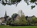
Saint-Martin church in Champteussé-sur-Baconne
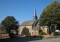
Saint-Pierre Church in Chenillé-Changé

Old watermill
Les Rues Castle


