Carbay
| Carbay | ||
|---|---|---|
|
|
||
| region | Pays de la Loire | |
| Department | Maine-et-Loire | |
| Arrondissement | Segré | |
| Canton | Segré | |
| Community association | Anjou Bleu Community | |
| Coordinates | 47 ° 44 ′ N , 1 ° 13 ′ W | |
| height | 54-101 m | |
| surface | 7.63 km 2 | |
| Residents | 260 (January 1, 2017) | |
| Population density | 34 inhabitants / km 2 | |
| Post Code | 49420 | |
| INSEE code | 49056 | |
| Website | http://carbayacoeur.blog4ever.com/blog/index-186135.html | |
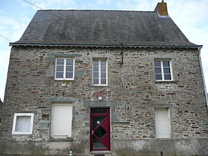
 Carbay Town Hall |
||
Carbay is a French municipality with 260 inhabitants (as of January 1 2017) in Canton Segre (2015: Canton Pouancé ) in Arrondissement Segré in the department of Maine-et-Loire and the region Pays de la Loire . The inhabitants are called Carbaisiens .
geography
Carbay is about 47 kilometers west-northwest of Angers . Carbay is surrounded by the neighboring communities of Ombrée d'Anjou in the north and east, Juigné-des-Moutiers in the south, Soudan in the west and Villepot in the north-west.
Population development
| 1962 | 1968 | 1975 | 1982 | 1990 | 1999 | 2006 | 2013 |
|---|---|---|---|---|---|---|---|
| 204 | 192 | 181 | 175 | 214 | 208 | 242 | 243 |
| Source: Cassini and INSEE | |||||||
Attractions
- Saint-Martin church, built between 1865 and 1867
literature
- Le Patrimoine des Communes de Maine-et-Loire . Flohic Editions, Volume 2, Paris 2001, ISBN 2-84234-117-1 , pp. 1021-1022.
Web links
Commons : Carbay - collection of pictures, videos and audio files
- Monuments historiques (objects) in Carbay in the base Palissy of the French Ministry of Culture

