
Juigné-des-Moutiers
|
Juigné-des-Moutiers Yaoueneg-ar-Mousterioù |
||
|---|---|---|

|
|
|
| region | Pays de la Loire | |
| Department | Loire-Atlantique | |
| Arrondissement | Châteaubriant-Ancenis | |
| Canton | Châteaubriant | |
| Community association | Châteaubriant-Derval | |
| Coordinates | 47 ° 41 ′ N , 1 ° 11 ′ W | |
| height | 52-102 m | |
| surface | 24.65 km 2 | |
| Residents | 345 (January 1, 2017) | |
| Population density | 14 inhabitants / km 2 | |
| Post Code | 44670 | |
| INSEE code | 44078 | |
| Website | www.juignedesmoutiers.fr | |
 Town hall ( Mairie ) of Juigné-des-Moutiers |
||

Juigné-des-Moutiers ( Breton : Yaoueneg-ar-Mousterioù ; Gallo : Junyaé ) is a French municipality with 345 inhabitants (as of January 1 2017) in the department of Loire-Atlantique in the Region Pays de la Loire ; it is part of the arrondissement of Châteaubriant-Ancenis and the canton of Châteaubriant (until 2015: Saint-Julien-de-Vouvantes ). The inhabitants are called Juignéens .
geography
Juigné-des-Moutiers is located about 60 kilometers southeast of Rennes and about 57 kilometers north-northeast of Nantes . Juigné-des-Moutiers is surrounded by the neighboring communities of Soudan in the north and north-west, Carbay in the south, Armaillé in the east and north-east, Ombrée d'Anjou in the east, La Chapelle-Glain and Saint-Julien-de-Vouvantes in the south and Erbray in the West.
Population development
| year | 1962 | 1968 | 1975 | 1982 | 1990 | 1999 | 2006 | 2012 |
| Residents | 513 | 435 | 389 | 366 | 335 | 322 | 325 | 352 |
| Source: Cassini and INSEE | ||||||||
Attractions
- Saint-Pierre church from 1878
- Grammontens priory La Primaudière
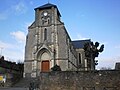
Saint-Pierre church
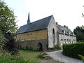
Grammontens Priory in La Primaudière

.JPG)
literature
- Le Patrimoine des Communes de la Loire-Atlantique . Flohic Editions, Volume 2, Charenton-le-Pont 1999, ISBN 2-84234-040-X , pp. 1108-1111.