Saint-Aubin-des-Châteaux
|
Saint-Aubin-des-Châteaux Sant-Albin-ar-C'hestell |
||
|---|---|---|

|
|
|
| region | Pays de la Loire | |
| Department | Loire-Atlantique | |
| Arrondissement | Châteaubriant-Ancenis | |
| Canton | Châteaubriant | |
| Community association | Châteaubriant-Derval | |
| Coordinates | 47 ° 44 ′ N , 1 ° 29 ′ W | |
| height | 32-92 m | |
| surface | 47.56 km 2 | |
| Residents | 1,795 (January 1, 2017) | |
| Population density | 38 inhabitants / km 2 | |
| Post Code | 44110 | |
| INSEE code | 44153 | |
| Website | http://www.saint-aubin-des-chateaux.fr/ | |
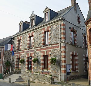
 Town hall (Mairie) of Saint-Aubin-des-Châteaux |
||
Saint-Aubin-des-Châteaux ( Breton : Sant-Albin-ar-C'hestell ; Gallo : Saent-Aubein-dez-Chastèus ) is a French commune with 1,795 inhabitants (as of January 1, 2017) in the Loire-Atlantique department in the region of Pays de la Loire ; it is part of the arrondissement of Châteaubriant-Ancenis and the canton of Châteaubriant . The inhabitants are called Aubinois (es) .
geography
Saint-Aubin-des-Châteaux is located about 48 kilometers south-southeast of Rennes and about 55 kilometers north-northeast of Nantes on the Chère River . Saint-Aubin-des-Châteaux is surrounded by the neighboring communities of Ruffigné in the north and northwest, Rougé in the north and northeast, Châteaubriant in the east, Louisfert in the south and southeast, Saint-Vincent-des-Landes in the south and Sion-les-Mines in the West.
Population development
| year | 1962 | 1968 | 1975 | 1982 | 1990 | 1999 | 2006 | 2013 |
| Residents | 1,520 | 1,472 | 1,387 | 1,351 | 1,346 | 1.314 | 1,456 | 1,688 |
| Source: Cassini and INSEE | ||||||||
Attractions
- Menhir Les Louères, Monument historique since 1928
- Le Plessis castle and park from the 15th century, renovations from the 17th century, monument historique since 1992
- Chapel of the Knights Templar from the 12th century
literature
- Le Patrimoine des Communes de la Loire-Atlantique . Flohic Editions, Volume 1, Charenton-le-Pont 1999, ISBN 2-84234-040-X , pp. 278-282.


