
Puceul
|
Puceul Puñsel |
||
|---|---|---|
.svg)
|
|
|
| region | Pays de la Loire | |
| Department | Loire-Atlantique | |
| Arrondissement | Châteaubriant-Ancenis | |
| Canton | Guémené-Penfao | |
| Community association | Nozay | |
| Coordinates | 47 ° 31 ′ N , 1 ° 37 ′ W | |
| height | 26-82 m | |
| surface | 20.09 km 2 | |
| Residents | 1,128 (January 1, 2017) | |
| Population density | 56 inhabitants / km 2 | |
| Post Code | 44390 | |
| INSEE code | 44138 | |
| Website | http://www.puceul.fr/ | |
 Town Hall (Mairie) of Puceul |
||

Puceul ( Breton : Puñsel ; Gallo : Puczoe ) is a French municipality with 1128 inhabitants (as of January 1 2017) in the department of Loire-Atlantique in the Region Pays de la Loire ; it belongs to the arrondissement of Châteaubriant-Ancenis and the canton of Guémené-Penfao (until 2015: canton of Nozay ). The inhabitants are called puceulois .
geography
Puceul is about 37 kilometers north of Nantes . Surrounded Puceul of the neighboring communities Nozay in the north, Abbaretz in the Northeast, Saffré the south and east, La Chevallerais in the southwest and La Grigonnais in the West.
The national route 137 runs through the municipality .
history
In 1949/1950 the municipality of La Chevallerais was separated from the municipality and became independent.
Population development
| year | 1962 | 1968 | 1975 | 1982 | 1990 | 1999 | 2006 | 2013 |
| Residents | 724 | 685 | 609 | 580 | 599 | 631 | 879 | 1,055 |
| Source: Cassini and INSEE | ||||||||
Attractions
- Saint-Martin Church, built in 1885
- Bohallard Castle, built around 1850
- Montmorency House
- La Savinais mansion
- Manor house of La Bellière
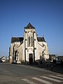
Saint Martin Church

Montmorency House


literature
- Le Patrimoine des Communes de la Loire-Atlantique . Flohic Editions, Volume 2, Charenton-le-Pont 1999, ISBN 2-84234-040-X , pp. 826-830.