
Treffieux
| Treffieux | ||
|---|---|---|
.svg)
|
|
|
| region | Pays de la Loire | |
| Department | Loire-Atlantique | |
| Arrondissement | Châteaubriant-Ancenis | |
| Canton | Guémené-Penfao | |
| Community association | Nozay | |
| Coordinates | 47 ° 37 ′ N , 1 ° 32 ′ W | |
| height | 19-54 m | |
| surface | 19.12 km 2 | |
| Residents | 883 (January 1, 2017) | |
| Population density | 46 inhabitants / km 2 | |
| Post Code | 44170 | |
| INSEE code | 44208 | |
| Website | http://www.treffieux.fr/ | |
 Treffieux town hall |
||

Treffieux ( Breton : Trefieg ) is a French municipality with 883 inhabitants (as of January 1 2017) in the department of Loire-Atlantique in the Region Pays de la Loire ; it belongs to the arrondissement of Châteaubriant-Ancenis and the canton of Guémené-Penfao (until 2015: canton of Nozay ). The inhabitants are called Treffiolais .
geography
Treffieux is about 18 kilometers southwest of Châteaubriant am Don , a tributary of the Vilaine . Treffieux is surrounded by the neighboring communities of Saint-Vincent-des-Landes in the north, Issé in the east, Abbaretz in the south and south-east, Nozay in the south and south-west and Jans in the west.
The former route nationale 171 (today's D771) crosses the municipality.
Population development
| year | 1962 | 1968 | 1975 | 1982 | 1990 | 1999 | 2006 | 2012 |
| Residents | 776 | 700 | 688 | 629 | 626 | 618 | 703 | 824 |
| Source: Cassini and INSEE | ||||||||
Attractions
- Menhir from La Bazinais
- Saint-Grégoire church, built around 1880
- La Fleuriais Chapel, built in the 16th century
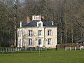
- 19th century mansion La Fleuriais
- Bégly Castle
- 19th century windmill

Menhir from La Bazinais
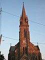
Saint-Grégoire church

La Fleuriais Chapel
Bégly Castle
.JPG)

.JPG)

literature
- Le Patrimoine des Communes de la Loire-Atlantique . Flohic Editions, Volume 2, Charenton-le-Pont 1999, ISBN 2-84234-040-X , pp. 835-839.