
Bouvron (Loire-Atlantique)
| Bouvron | ||
|---|---|---|

|
|
|
| region | Pays de la Loire | |
| Department | Loire-Atlantique | |
| Arrondissement | Châteaubriant-Ancenis | |
| Canton | Blain | |
| Community association | Region de Blain | |
| Coordinates | 47 ° 25 ′ N , 1 ° 51 ′ W | |
| height | 11-82 m | |
| surface | 47.63 km 2 | |
| Residents | 3,115 (January 1, 2017) | |
| Population density | 65 inhabitants / km 2 | |
| Post Code | 44130 | |
| INSEE code | 44023 | |
| Website | http://www.mairie-bouvron.fr/ | |
 Town hall (Mairie) of Bouvron |
||

Bouvron ( Breton : Bolvronn ) is a French municipality with 3115 inhabitants (as of January 1 2017) in the department of Loire-Atlantique in the Region Pays de la Loire . It belongs to the arrondissement of Châteaubriant-Ancenis and the canton of Blain . The inhabitants are called Bouvronnais .
geography
Bouvron is about 50 kilometers northwest of Nantes . Neighboring municipalities of Bouvron are Guenrouet in the north, Blain in the northeast, Fay-de-Bretagne in the east, Savenay in the south and southwest, Campbon in the west and Quilly in the west.
The national route 171 runs through the municipality .
Population development
| 1962 | 1968 | 1975 | 1982 | 1990 | 1999 | 2006 | 2012 |
|---|---|---|---|---|---|---|---|
| 2,278 | 2,285 | 2,295 | 2,334 | 2,402 | 2,408 | 2,575 | 2,961 |
Attractions
See also: List of Monuments historiques in Bouvron (Loire-Atlantique)
- Saint-Sauveur church
- Saint-Julien Chapel, rebuilt in 1962
- Saint-André chapel, originally from the 10th century, largely rebuilt in the 20th century
- Quéhillac castle from the 16th and 17th centuries, with Saint-Mathieu chapel, monument historique since 2002
- Launay-Bedeau Castle

Saint-Sauveur church
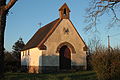
Saint-André chapel

Quéhillac Castle


literature
- Le Patrimoine des Communes de la Loire-Atlantique . Flohic Editions, Volume 1, Charenton-le-Pont 1999, ISBN 2-84234-040-X , pp. 138-146.
Web links
Commons : Bouvron - collection of images, videos and audio files