
Lusanger
|
Lusanger Luzevieg |
||
|---|---|---|
.svg)
|
|
|
| region | Pays de la Loire | |
| Department | Loire-Atlantique | |
| Arrondissement | Châteaubriant-Ancenis | |
| Canton | Guémené-Penfao | |
| Community association | Châteaubriant-Derval | |
| Coordinates | 47 ° 41 ′ N , 1 ° 35 ′ W | |
| height | 21-72 m | |
| surface | 35.38 km 2 | |
| Residents | 1,047 (January 1, 2017) | |
| Population density | 30 inhabitants / km 2 | |
| Post Code | 44590 | |
| INSEE code | 44086 | |
| Website | http://www.mairie-lusanger.fr/ | |
 Town hall (Mairie) of Lusanger |
||

Lusanger ( Breton : Luzevieg ; Gallo : Lusanjae ) is a French municipality with 1047 inhabitants (as of January 1 2017) in the department of Loire-Atlantique in the Region Pays de la Loire ; it belongs to the arrondissement of Châteaubriant-Ancenis and the canton of Guémené-Penfao (until 2015: canton of Derval ). The inhabitants are called Lusangéens .
geography
Lusanger is about 60 kilometers north-northwest of Nantes . Lusanger is surrounded by the neighboring communities of Sion-les-Mines in the north, Saint-Vincent-des-Landes in the east, Jans in the south, Derval in the west and Mouais in the northwest.
Population development
| year | 1962 | 1968 | 1975 | 1982 | 1990 | 1999 | 2006 | 2013 |
| Residents | 1,063 | 1,020 | 934 | 914 | 926 | 947 | 1,000 | 1,026 |
| Source: Cassini and INSEE | ||||||||
Attractions
- Menhir Pierre du Hochu
- Menhir du Tertre Gicquel
- Alignement de la Grée Galot
- Saint-Jean-Baptiste Church, built from 1866 to 1869
- Saint-Jean church, built in the 12th century, rebuilt in the 15th century, monument historique since 1997
- Saint-Côme-et-Saint-Damien chapel from the 19th century
- Saint-Émilie Castle
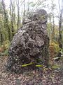
Menhir from Le Hochu
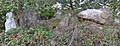
Mégalithes de la Pierre

Saint-Jean-Baptiste church


literature
- Le Patrimoine des Communes de la Loire-Atlantique . Flohic Editions, Volume 1, Charenton-le-Pont 1999, ISBN 2-84234-040-X , pp. 376-379.
Web links
Commons : Lusanger - collection of images, videos and audio files