
Le Gâvre
| Le Gâvre | ||
|---|---|---|
.svg)
|
|
|
| region | Pays de la Loire | |
| Department | Loire-Atlantique | |
| Arrondissement | Châteaubriant-Ancenis | |
| Canton | Blain | |
| Community association | Region de Blain | |
| Coordinates | 47 ° 31 ′ N , 1 ° 45 ′ W | |
| height | 22-62 m | |
| surface | 53.58 km 2 | |
| Residents | 1,796 (January 1, 2017) | |
| Population density | 34 inhabitants / km 2 | |
| Post Code | 44130 | |
| INSEE code | 44062 | |
| Website | http://www.legavre.fr/ | |
 Le Gâvre Town Hall |
||

Le Gâvre ( Breton : Ar C'havr ) is a French municipality with 1,796 inhabitants (as of January 1 2017) in the department of Loire-Atlantique in the Region Pays de la Loire . It belongs to the arrondissement of Châteaubriant-Ancenis and the canton of Blain . The inhabitants are called Gavrais .
geography
Le Gâvre is about 50 kilometers northwest of Nantes . The municipality is crossed by the Perche river, which here also forms the Étang de Clegreuc lake . Neighboring communities of Le Gâvre are Guémené-Penfao in the north, Vay in the east and northeast, Blain in the south, Guenrouet in the west and southwest and Plessé in the west.
Population development
| 1962 | 1968 | 1975 | 1982 | 1990 | 1999 | 2006 | 2012 |
|---|---|---|---|---|---|---|---|
| 911 | 861 | 825 | 892 | 995 | 945 | 1,256 | 1,677 |
Attractions
- Notre-Dame church, originally built as a ducal chapel in 1226, rebuilt in the 15th century, restoration work in the 20th century, monument historique since 1926
- Sainte-Madeleine Chapel, originally built as an infirmary around 1160, rebuilt in the 15th century
- Domain La Genestrie
- House Benoist, today's museum, built in 1648
- Le Pont-Quenil house from the 17th century
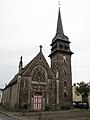
Notre-Dame church
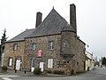
House Benoist (today's museum)


literature
- Le Patrimoine des Communes de la Loire-Atlantique . Flohic Editions, Volume 1, Charenton-le-Pont 1999, ISBN 2-84234-040-X , pp. 151-157.
Web links
Commons : Le Gâvre - collection of images, videos and audio files