
Fercé
| Fercé | ||
|---|---|---|
.svg)
|
|
|
| region | Pays de la Loire | |
| Department | Loire-Atlantique | |
| Arrondissement | Châteaubriant-Ancenis | |
| Canton | Châteaubriant | |
| Community association | Châteaubriant-Derval | |
| Coordinates | 47 ° 48 ′ N , 1 ° 25 ′ W | |
| height | 42-117 m | |
| surface | 22.04 km 2 | |
| Residents | 474 (January 1, 2017) | |
| Population density | 22 inhabitants / km 2 | |
| Post Code | 44660 | |
| INSEE code | 44058 | |
 Town hall (Mairie) of Fercé |
||

Fercé ( Breton : Ferreg ; Gallo : Fèrczaé ) is a French municipality with 474 inhabitants (as of January 1 2017) in the department of Loire-Atlantique in the Region Pays de la Loire ; it belongs to the arrondissement of Châteaubriant-Ancenis and the canton of Châteaubriant (until 2015: canton of Rougé ). The inhabitants are called Fercéens in French .
geography
Fercé is located about 66 kilometers northeast of Nantes and about 40 kilometers southeast of Rennes . The Brutz limits the community in the south and the Semnon in the north. Fercé is surrounded by the neighboring communities Martigné-Ferchaud in the north and east, Noyal-sur-Brutz in the south-east, Rougé in the south and west, Soulvache in the west and north-west and Thourie in the north-west.
Population development
| year | 1962 | 1968 | 1975 | 1982 | 1990 | 1999 | 2006 | 2012 |
| Residents | 561 | 545 | 501 | 459 | 499 | 517 | 485 | 500 |
| Source: Cassini and INSEE | ||||||||
Attractions
- Church from 1702
- Le Boispéan castle from the 17th century

church
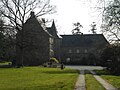
Le Boispéan Castle


literature
- Le Patrimoine des Communes de la Loire-Atlantique . Flohic Editions, Volume 2, Charenton-le-Pont 1999, ISBN 2-84234-040-X , pp. 1017-1021.
Web links
- Monuments historiques (objects) in Fercé in the base Palissy of the French Ministry of Culture