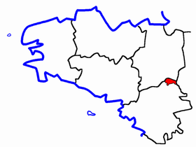
Canton of Rougé
| Former Canton of Rougé |
|
|---|---|
| region | Pays de la Loire |
| Department | Loire-Atlantique |
| Arrondissement | Châteaubriant |
| main place | Rouge |
| Dissolution date | March 29, 2015 |
| Residents | 4,362 (Jan 1, 2012) |
| Population density | 37 inhabitants / km² |
| surface | 117.93 km² |
| Communities | 5 |
| INSEE code | 4434 |
The Canton Rougé was 2015 a French canton in the Arrondissement Châteaubriant , in the Loire-Atlantique and the region Pays de la Loire ; its main town was Rougé .
location
Communities
The canton of Rougé comprised five municipalities:
| local community | Breton | Population (2012) |
Area (km²) |
Code postal | Code Insee |
|---|---|---|---|---|---|
| Fercé | Ferreg | 501 | 22.04 | 44660 | 44058 |
| Noyal-sur-Brutz | Noal-ar-Bruz | 585 | 7.71 | 44110 | 44112 |
| Rouge | Ruzieg | 2,232 | 56.32 | 44660 | 44146 |
| Soulvache | Soulvac'h | 389 | 11.27 | 44660 | 44200 |
| Villepot | Kerbod | 655 | 20.59 | 44110 | 44218 |
| Canton | Ruzieg | 4,362 | 117.93 | - | 4434 |
Population development
| 1962 | 1968 | 1975 | 1982 | 1990 | 1999 | 2006 | 2012 |
|---|---|---|---|---|---|---|---|
| 4,392 | 4,277 | 4,061 | 4.015 | 4,201 | 4.212 | 4,356 | 4,362 |
