Davao de Oro
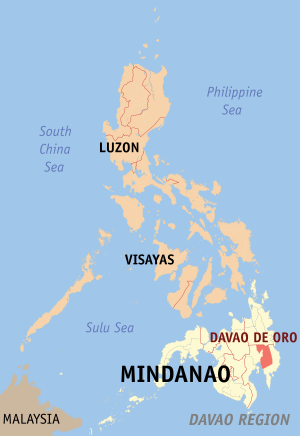
Davao de Oro , formerly Compostela Valley , is a province in the southeast of the island of Mindanao and belongs to the island state of the Philippines . The province is politically assigned to the Davao Region District , Region XI.
The seat of the provincial administration is in the municipality of Nabunturan .
The governor of the province is Arturo T. Uy.
geography
The province of Davao del Norte lies west of Davao de Oro , Agusan del Sur to the north and Davao Oriental to the east . In the southwest is the coastline to the Gulf of Davao .
The eastern part of Davao de Oro in particular is mountainous, while the south tapers flat towards the coastline. The stratovolcano Leonard Kniaseff can be found in the east .
The province has an area of 4,667 km².
Demographics and language
According to the 2007 census, Davao de Oro has 637,366 people. The province ranks 44th in the population statistics.
The population density is 136.6 people per km². This means the 19th place in the demographic statistics of the Philippines, of the least populated provinces.
Most residents come from immigrants from the Visayas from that in the course of the 20th century in Mindanao settled. Other groups of immigrants were the Ilocanos, the Tagalogs and the Ilonggos.
Together with the indigenous ethnic groups of the Ata talaingod, the Dibabaonon, the Manguwangan, the Mandaya and the Mansaka, they make the province a melting pot of cultures.
The dominant languages in the province are Cebuano / Visayan and Tagalog . In addition, the dialects Mandaya, Mansaka, Hiligaynon , Ilokano , Waray-Waray , Maranao and Suriganonon are used by minorities in the province.
economy
The main source of income for the provincial residents is agriculture. Mainly rice , coconut , pineapple , coffee and bananas are grown.
Since the region is also rich in mineral resources, mining is another important industry in the province.
The inhabitants on the coast live mainly from fishing. Milk fish , tilapia and other seafood are brought from the depths of the Davao Gulf and sold in the markets. Many residents also have large fish ponds for breeding fish for food.
Not to be forgotten is tourism. The province is home to numerous waterfalls, hot and cold springs, lakes, beaches and heights, as well as some interesting natural parks.
Colleges
- University of Southeastern Philippines campus in Mabini
Political structure
The province of Davao de Oro is divided into 11 independently administered municipalities. The communities in turn are subdivided into a total of 235 barangays (districts).
The province is divided into 2 congressional districts.
Communities
climate
The climate in the province is not determined by a pronounced dry or rainy season. Rainfalls can occur all year round.
On the one hand, the province lies outside the typhoon belt, which grazes the north of the Philippines , on the other hand, the mountain ranges in the east protect the province from strong tropical storms. In 2012, however, the area was hit hard by Typhoon Pablo .
history
Davao de Oro belonged together with Davao del Norte , Davao Oriental and Davao del Sur and the city of Davao City to a former large province called Davao.
With the Republic Act No. 4867, signed by President Ferdinand Marcos on May 8, 1967, this was divided into the named provinces.
Davao del Norte was originally divided into 13 independently administered municipalities. On May 6, 1970, 6 more were added. A passage in Republic Act No. 6430 of June 17, 1972 changed the name of the province from Davao del Norte to Davao .
In 1996 the number of parishes rose to a total of 22 through the formation of San Vicente (today Laak) in 1979, Maragusan in 1988 and Talaingod in 1990.
On January 31, 1998, President Fidel Ramos signed Republic Act No. 8470, which separated the Compostela Valley Province from Davao.
Attractions
- The Aguacan Inland Resort in Maragusan
- The Tagbibinta Falls in Maragusan
- The Kumbilan Caves in Nabunturan
- Mt Candalaga in Maragusan
- The Manurigao Falls in New Bataan
- The Mainit Hotspring Protected Landscape nature park in Nabunturan
- The San Vicente Caves in Nabunturan
- The Pantukan Beach Resorts and Hotels in Magnaga,
- The Mabini Protected Landscape and Seascape
- The Aliwagwag Protected Landscape nature reserve
Web links
Coordinates: 7 ° 36 ' N , 125 ° 57' E
