
Debin
| Urban-type settlement
Debin
Дебин
|
||||||||||||||||||||||||||||||||
|
||||||||||||||||||||||||||||||||
|
||||||||||||||||||||||||||||||||


Debin ( Russian Де́бин ) is an urban-type settlement in the Magadan Oblast ( Russia ) with 721 inhabitants (as of October 14, 2010).
geography
The place is a good 300 km as the crow flies north of the Magadan Oblast Administrative Center on the left bank of the Kolyma , about 40 km below the Kolyma reservoir .
Debin belongs to Jagodninsky Rajon and is located about 60 km east-southeast of its administrative center Jagodnoye . The settlement is the seat and only locality of the municipality (gorodskoje posselenije) Possjolok Debin.

Debin at Kolyma
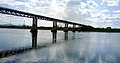
Road bridge over the Kolyma near Debin

history
The settlement was established in 1935, when a ferry connection was established there over the Kolyma, and was therefore initially called Pereprawa (Russian roughly translation center ). After a bridge was built, it was renamed Debin in 1937 , after the river Debin, which flows a few kilometers upstream (south) from the left into the Kolyma . In Debin is one of the larger was the Gulag - camps in Kolymagebiet , and from the 1940s and whose central hospital. The writer Warlam Shalamov worked there while he was in camp.
Debin has had urban-type settlement status since 1953.
Population development
| year | Residents |
|---|---|
| 1959 | 4759 |
| 1970 | 2037 |
| 1979 | 2921 |
| 1989 | 2387 |
| 2002 | 921 |
| 2010 | 721 |
Note: census data
traffic
At Debin, the R504 Kolyma trunk road , which connects Magadan with Nizhny Bestjach near Jakutsk (previously M56 , number still in use until 2017), crosses Kolyma. There a road branches off to the settlement of Sinegorje , a good 30 km south-west, directly below the Kolyma dam . Another road leads from Debin down the left Kolymaufer and on to the settlement of Elgen and the village of Taskan , with a junction to Verkhni At-Urjach .
Individual evidence
- ↑ a b Itogi Vserossijskoj perepisi naselenija 2010 goda. Tom 1. Čislennostʹ i razmeščenie naselenija (Results of the All-Russian Census 2010. Volume 1. Number and distribution of the population). Tables 5 , pp. 12-209; 11 , pp. 312–979 (download from the website of the Federal Service for State Statistics of the Russian Federation)
| Cities | ||
| Urban-type settlements |
Arman | Atka | Burchala | Cholodny | Debin | Ducat | Evensk R | Jagodnoye R | Karamken | Mjaundscha | Ola R | Omsukhan R | Orotucan | Palatka R | Siroki | Seimchan R | Sinegorje | Sokol | Stekolny | Talaja | Uptar | Ust-Omtschug R |