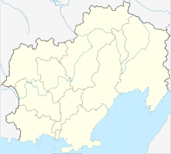
Ola (Russia)
| Urban-type settlement
Ola
Ола
|
||||||||||||||||||||||||||||||
|
||||||||||||||||||||||||||||||
|
||||||||||||||||||||||||||||||
Ola ( Russian О́ла ) is an urban-type settlement in the Magadan Oblast ( Russia ) with 6,215 inhabitants (as of October 14, 2010).
geography
The settlement is located on the coast of the Sea of Okhotsk on the left bank of the Ola river of the same name, not far from its confluence with the Ola lagoon (Olskaja laguna) , which opens a few kilometers east to the sea. Ola is about 30 kilometers eastward as the crow flies from Magadan Oblast Administrative Center .
Ola is the administrative center of the Ola Rajon of the same name .
history
A first settlement on the site of the present-day town was probably built by Russian Cossacks as early as the end of the 1640s while they were advancing east, shortly after they first reached the Sea of Okhotsk and the first settlement of Okhotsk was founded . The first written mention of the place comes from the year 1716. In the 19th century, before the foundation of Magadan, Ola was the starting point of the Ola-Kolyma tract, the trade route between the Sea of Okhotsk and the upper reaches of the Kolyma . Annual fairs were held in the village.
On January 4, 1926, Ola became the administrative center of a newly created Rajon. The landing of a geological expedition under Yuri Bilibin on board the (former Japanese ) steamship Daiboshi Maru in Ola on July 4, 1928 is considered to be the beginning of the economic development of the Kolyma region during the Soviet period. In 1957, Ola was given urban-type settlement status.
Population development
| year | Residents |
|---|---|
| 1939 | 677 |
| 1959 | 3,842 |
| 1970 | 6,295 |
| 1979 | 8.223 |
| 1989 | 10.122 |
| 2002 | 6,842 |
| 2010 | 6.215 |
Note:: census data
Culture and sights
There has been a local museum in Ola since 1976.
Economy and Infrastructure
The main industries are fishing and fish processing. In the area there is agriculture for the regional supply (cultivation of potatoes and vegetables, cattle farming).
Ola is connected to Magadan by a road that crosses the Ola river with a bridge near the village and continues upstream to the villages of Saretschny and Gadlja, a few kilometers away.
Individual evidence
- ↑ a b Itogi Vserossijskoj perepisi naselenija 2010 goda. Tom 1. Čislennostʹ i razmeščenie naselenija (Results of the All-Russian Census 2010. Volume 1. Number and distribution of the population). Tables 5 , pp. 12-209; 11 , pp. 312–979 (download from the website of the Federal Service for State Statistics of the Russian Federation)
- ↑ Ola in the regional internet portal kolyma.ru (Russian)
- ↑ a b Ola on the website of the Geographical Institute of the RAN (Russian)
- ↑ Information about the museum at museum.ru (Russian)

