
Ust-Omtschug
| Urban-type settlement
Ust-Omchug
Усть-Омчуг
|
||||||||||||||||||||||||||||||
|
||||||||||||||||||||||||||||||
|
||||||||||||||||||||||||||||||


Ust-Omtschug ( Russian Усть-О́мчуг ) is an urban-type settlement in the Magadan Oblast ( Russia ) with 3914 inhabitants (as of October 14, 2010).
geography
The settlement lies in the middle of the southeastern foothills of the Suntar-Chajata Mountains , which reach an altitude of over 1,800 m in the area , at the confluence of the left tributary Omtschug in the Kolyma tributary Detrin . Ust-Omtschug is around 180 kilometers as the crow flies in a north-westerly direction from the Magadan Oblast Administrative Center .
Ust-Omchug is the administrative center of the Rajons Tenkinski .
history
The place was created from 1939 in connection with the development of gold and tin deposits in the area.
From 1949 to 1956 the administration of the Tenka prison camp (TenLag) of the Dalstroi administration in the Gulag system was in Ust-Omtschug with up to 18,000 prisoners who were employed in mining and forestry.
In 1953 the status of an urban-type settlement was given and the place was the administrative center of the newly created Tenkinski district.
Population development
|
||||||||||||||
| Note: census data |
Economy and Infrastructure
Ust-Omtschug is the logistic center for the mining companies based in the area (mainly gold, next to silver). In addition, forestry and agriculture are operated for local needs.
The settlement is on a regional road that branches off the M56 highway (the former Kolymatrakt ) in the neighboring district administration center of Palatka, 180 kilometers away, and continues to the northwest, where it reaches the M56 west of Sussuman after another 300 kilometers .
Picture gallery

Ust-Omtschug (1958)

House in Ust-Omtschug (2004)
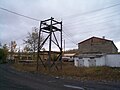
Ust-Omtschug (2009)

Ust-Omtschug (2009)


Personalities
From 1949 to 1953 the German literary scholar Trude Richter lived in Ust-Omtschug during her exile.
Individual evidence
- ↑ a b Itogi Vserossijskoj perepisi naselenija 2010 goda. Tom 1. Čislennostʹ i razmeščenie naselenija (Results of the All-Russian Census 2010. Volume 1. Number and distribution of the population). Tables 5 , pp. 12-209; 11 , pp. 312–979 (download from the website of the Federal Service for State Statistics of the Russian Federation)
- ↑ Tenka-ITL in the GULAG Internet portal of Memorial Deutschland e. V.
- ↑ a b Ust-Omtschug on the website of the Geographical Institute of the RAN (Russian)
- ↑ a b Rajon Tenkinsky in the regional information portal kolyma.ru (Russian)
Web links
| Cities | ||
| Urban-type settlements |
Arman | Atka | Burchala | Cholodny | Debin | Ducat | Evensk R | Jagodnoye R | Karamken | Mjaundscha | Ola R | Omsukhan R | Orotucan | Palatka R | Siroki | Seimchan R | Sinegorje | Sokol | Stekolny | Talaja | Uptar | Ust-Omtschug R |