Mjaundscha
| Urban-type settlement
Mjaundscha
Мяунджа
|
||||||||||||||||||||||||||||||
|
||||||||||||||||||||||||||||||
|
||||||||||||||||||||||||||||||
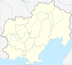
Mjaundscha ( Russian Мя́унджа ) is an urban-type settlement in the Magadan Oblast ( Russia ) with 1663 inhabitants (as of October 14, 2010).
geography
The place is a good 430 km as the crow flies north-northwest of the Magadan Oblast Administrative Center in the Kolyma Mountains on the right bank of the eponymous river Mjaundscha in the system of the left Kolyma source river Ajan-Jurjach .
Mjaundscha belongs to the Sussumanski Rajon and is located almost 60 km northwest of the Sussuman administrative center . The settlement is the seat of the municipality (gorodskoje posselenije) Possjolok Mjaundscha, which also includes the 7 km southwest of Kedrowy.
history
The settlement was created from 1950 in connection with the construction of the Arkagalinskaya GRES thermal power plant , the first block of which with an output of 25 MW was put into operation in 1955. Since 1957 Mjaundscha has had the status of an urban-type settlement.
Population development
| year | Residents |
|---|---|
| 1959 | 4390 |
| 1970 | 3342 |
| 1979 | 5001 |
| 1989 | 5090 |
| 2002 | 2131 |
| 2010 | 1663 |
Note: census data
Economy and Transport
The local company is the Arkagalinskaja GRES thermal power plant with an output of 224 MW today, which is operated by Magadanenergo and is the oblast's most important electrical energy supplier after the Kolyma hydropower plant .
A few kilometers west of the settlement, between Mjaundscha and Kedrowy, the R504 Kolyma road passes, which connects Magadan with Nizhny Bestjach near Jakutsk (previously M56 , number still in use until 2017). From Mjaundscha in a south-easterly direction, first up the river Mjaundscha and over a 1200 m high pass an alternative route to Sussuman, which is shorter but unpaved.
Individual evidence
- ↑ a b Itogi Vserossijskoj perepisi naselenija 2010 goda. Tom 1. Čislennostʹ i razmeščenie naselenija (Results of the All-Russian Census 2010. Volume 1. Number and distribution of the population). Tables 5 , pp. 12-209; 11 , pp. 312–979 (download from the website of the Federal Service for State Statistics of the Russian Federation)

