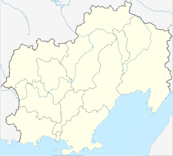
Cholodny (Magadan)
| Urban-type settlement
Cholodny
Холодный
|
||||||||||||||||||||||||||||
|
||||||||||||||||||||||||||||
|
||||||||||||||||||||||||||||
Cholodny ( Russian Холо́дный ) is an urban-type settlement in the Magadan Oblast ( Russia ) with 1062 inhabitants (as of October 14, 2010).
geography
The place is located about 380 km as the crow flies north-northwest of the Magadan Oblast Administrative Center in the Kolyma Mountains , on the right bank of the Bereljoch , a left tributary of the left Kolyma source river Ajan-Jurjach .
Cholodny belongs to the Sussumansky Rajon and is located 14 km west-southwest of its Sussuman administrative center . The settlement is the seat and only locality of the municipality (gorodskoje posselenije) Possjolok Cholodny.
history
The settlement emerged from a gold prospector camp set up in 1941 . Since 1962 Cholodny has had the status of an urban-type settlement. The name means cold in Russian .
Population development
| year | Residents |
|---|---|
| 1970 | 1181 |
| 1979 | 1411 |
| 1989 | 1826 |
| 2002 | 1344 |
| 2010 | 1062 |
Note: census data
traffic
Cholodny is on the R504 Kolyma highway , which connects Magadan with Nizhny Bestjach near Yakutsk (previously M56 , number still in use until 2017).
Individual evidence
- ↑ a b Itogi Vserossijskoj perepisi naselenija 2010 goda. Tom 1. Čislennostʹ i razmeščenie naselenija (Results of the All-Russian Census 2010. Volume 1. Number and distribution of the population). Tables 5 , pp. 12-209; 11 , pp. 312–979 (download from the website of the Federal Service for State Statistics of the Russian Federation)

