Pomalca district
| Pomalca district | |||
|---|---|---|---|
 The district of Pomalca is located in the central northwest of the province of Chiclayo (marked in red) |
|||
| Symbols | |||
|
|||
| Basic data | |||
| Country | Peru | ||
| region | Lambayeque | ||
| province | Chiclayo | ||
| Seat | Pomalca | ||
| surface | 80.4 km² | ||
| Residents | 25,267 (2017) | ||
| density | 314 inhabitants per km² | ||
| founding | January 29, 1998 | ||
| ISO 3166-2 | PE-LAM | ||
| Website | www.munimdp.gob.pe (Spanish) | ||
| politics | |||
| Alcalde District | Julio Nestor Lazo Pomares (2019-2022) |
||
| Political party | Partido Aprista Peruano | ||
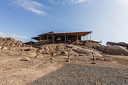
| Huaca Ventarrón, 4.3 km south-southeast of Pomalca | |||
Coordinates: 6 ° 46 ′ 12 " S , 79 ° 46 ′ 28" W
The Pomalca district is located in the Chiclayo province in the Lambayeque region in northwestern Peru . The district was formed on January 29, 1998 from parts of the Picsi district. It has an area of 80.35 km² (according to other sources: 76.6 km²). The 2017 census counted 25,267 inhabitants. Ten years earlier the population was 23,092. The seat of the district administration is the 88 m high town of Pomalca with 19,812 inhabitants (as of 2017). Pomalca is 7 km east of the city center of the regional and provincial capital Chiclayo . The archaeological site of Huaca Ventarrón is located 4.3 km south-southeast of Pomalca not far from the north bank of the Río Chancay .
The Pomalca district is located in the coastal plain of northwestern Peru, immediately east of the city of Chiclayo . The Río Chancay flows west along the southern district boundary. Irrigated agriculture is practiced in the district.
The Pomalca district is bordered to the west by the district Chiclayo , on the north by the district Picsi, on the east by the district Tumán and on the south by the districts Saña , Reque and Monsefú .
Individual evidence
- ↑ a b PERU: Lambayeque region - provinces and districts . www.citypopulation.de. Retrieved April 9, 2020.


