Three-man tip
| Three-man tip | ||
|---|---|---|
|
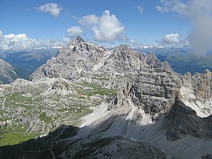
Dreischusterspitze (left), Schusterplatte and Innichriedlknoten, including the Paternkofel from the summit of the Kleiner Zinne |
||
| height | 3145 m slm | |
| location | South Tyrol , Italy | |
| Mountains | Sexten Dolomites | |
| Dominance | 13.3 km → Piz Popena | |
| Notch height | 1393 m ↓ Misurina | |
| Coordinates | 46 ° 40 ′ 7 ″ N , 12 ° 19 ′ 5 ″ E | |
|
|
||
| First ascent | Paul Grohmann with the guides Franz Innerkofler and Peter Salcher (July 18, 1869) | |
| Normal way | From the east over the Steinalpenscharte in difficulty level UIAA III (eIV +) | |
The Dreischusterspitze ( Italian Punta dei Tre Scarperi or Cima di Tre Scarperi ) is at 3145 m slm the highest mountain in the Sesto Dolomites in South Tyrol .
Location and surroundings
The Dreischusterspitze lies east of the Innerfeldtal and west of the Fischleintal , two side valleys of the Sextental . The mountain is in the area of the Drei Zinnen nature park .
The Dreischusterspitze massif includes several other secondary peaks, including the Northern Gsellknoten ( Cima di Sesto Nord , 2875 m ), the Southern Gsellknoten ( Cima di Sesto Sud , 2870 m ), the Sexten Tower ( Torre di Sesto , 2596 m ) and the Steinalpentürme ( 2575 m ) in the north, the Kleiner Schuster ( Punta Piccola dei Tre Scarperi , 3125 m ), the Hochwandspitz ( 2392 m ) in the west and the Wiener Turm ( 3095 m ) in the south. The ridge continues south of the Vienna Tower over the 2880 m high Weisslahnscharte ( Forcella Lavina Bianca ) to the Weisslahnspitze ( Punta Lavina Bianca , 2987 m ) and the Schusterplatte ( Lastron dei Scarperi , 2957 m ).
The municipal boundary between Sexten and Innichen runs through the massif .
Refuge huts in the area are the Dreischusterhütte ( Rifugio Tre Scarperi , 1653 m ) in the Innerfeldtal and the Talschlusshütte ( Rifugio al Fondo Valle , 1548 m ) in the Fischleintal and the Dreizinnenhütte ( Rifugio Locatelli , 2405 m ) in the south of the Schusterplatte.
Dreischusterspitze and Haunold (behind) seen from the Paternsattel
Rock beside the Dreischusterspitze from Altensteintal seen from
Climbs
Because of its complicated structure and its fragile rock, the Dreischusterspitze is considered to be challenging in terms of alpinism. Even the easiest ascent, the normal route with difficulty III (UIAA) is a long, serious and technically demanding climbing tour . It leads from the Dreischusterhütte through the northwestern Steinalpkar to the Steinalpscharte and then through the eastern flank. This path is also the usual descent route.
Further climbs are the Innerkofler through the west face (III), Innerkofler / Artmann (III) over the west pillar, de Bertoldi (V) over the north-west ridge, the north-east ridge (IV) and Langl / Löschner (IV) through the north face, at the ice equipment is necessary.
history
The Dreischusterspitze was by on July 18, 1869 Paul Grohmann and the leaders Franz Innerkofler from Sesto and Peter Salcher from Luggau Maria about today's normal route first climbed . It took the company from their bivouac, 1½ hours above Sexten, about five hours to the summit. The first ascent of the west face by Veit Innerkofler and his companions in 1888 is considered to be significant in terms of alpine history .
Literature and map
- Richard Goedeke : Alpine Club Guide Sexten Dolomites. Bergverlag Rother , Munich 1988, ISBN 3-7633-1255-2 .
- Dolomiti di Sesto / Sexten Dolomites - Alta Pusteria, Sexten, San Candido, Toblach. Hiking map 1: 25,000, sheet 010. Casa Editrice Tabacco , Tavagnacco 2002, ISBN 978-88-8315-010-4 .
Web links
- Dreischusterspitze on Peakbagger.com (English)
Individual evidence
- ↑ a b Istituto Geografico Militare : IGM 1: 25.000, Portale Cartografico Nazionale , accessed on November 21, 2011.
- ↑ a b c Kompass Karten (Ed.): Digital map of South Tyrol / Alto Adige . Rum 2007, ISBN 978-3-85491-631-4 ( online ).
- ↑ a b c d Richard Goedeke : Sexten Dolomites. Alpine Club Guide . Bergverlag Rother , Munich 1988, ISBN 3-7633-1255-2 , p. 56 ff .
- ^ Anton von Ruthner In: Yearbook of the Austrian Alpine Association. , Volume 6, Vienna 1870, p. 298.


