Edremit (Balikesir)
| Edremit | ||||
|
||||
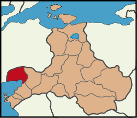
 Location of Edremit within Balikesir |
||||
| Basic data | ||||
|---|---|---|---|---|
| Province (il) : | Balikesir | |||
| Coordinates : | 39 ° 35 ' N , 27 ° 1' E | |||
| Telephone code : | (+90) 266 | |||
| Postal code : | 10300 | |||
| License plate : | 10 | |||
| Structure and administration (as of 2019) | ||||
| Structure : | 47 Mahalles | |||
| Mayor : | Selman Hasan Arslan ( CHP ) | |||
| Postal address : | Soğanyemez Mah. Yılmaz Akpınar Bulvarı 9 / B 10300 Edremit / Balıkesir |
|||
| Website: | ||||
| Edremit county | ||||
| Residents : | 154,487 (2018) | |||
| Surface: | 682 km² | |||
| Population density : | 227 inhabitants per km² | |||
| Kaymakam : | Ali Sırmalı | |||
| Website (Kaymakam): | ||||
Edremit (from ancient Greek Άδραμύττιον ; earlier Ottoman ادرمد Edremid ) is a city in the district of the same name in the Turkish province of Balıkesir and at the same time a district of the Büyükşehir belediyesi Balıkesir (metropolitan municipality / metropolitan province ) created in 2012 . Edremit is located about 75 km west of Balıkesir, on the Gulf of Edremit (Edremit Körfezi) on the flat foothills of the Paşadağ. Since the territorial reform in 2012, the district town has been identical in area and population to the district.
The area around the village, which is about 10 km from the sea, forms a fertile alluvial plain, where mainly olives, maize, grain and figs are harvested. In the center of the district, north of the city, lies the 21,300 hectare Kazdağı National Park , which surrounds the center of the Kaz Dağı, the historic Ida Mountains .
Edremit has an airport ( Balikesir Korfez Airport ).
history
After the destruction of the previous settlement Adramyttion by the Seljuks Çaka Bey in 1093, the city was rebuilt by Philokales, a general of the Byzantine emperor Alexios . Manuel I reinforced the fortifications against the Turkish threat. In the 14th century the city fell to the Beylik of the Karesi , in the reign of Sultan Orhan finally the Ottomans conquered Edremit in the middle of the 14th century .
Attractions
The city has a municipal museum, which shows a rich collection of weapons in addition to sparse archaeological finds. The Kurşunlu Cami (Kurşunlu Mosque) was built in 1231 by the Seljuk Yusuf Sinan.
Lying on the Gulf of Edremit
- the ruins of the ancient Aeolian city of Antandros , about 20 km west of Altınoluk
- near Küçükkuyu , about 35 km to the west, on a mountain the remains of a Roman military station, called Zeus Altar
From the predecessor settlement Adramyttion, about 13 km southwest of today's Ören, no significant relics have been preserved.

Web links
- Mahallelere Göre Balıkesir Edremit (List of all districts from 2013, with population and gender)
- Edremit Mahalleleri Nüfusu Balıkesir (List of all districts 2012–2018, with population figures )
- on Twitter
- at Facebook
- on Instagram
- Information portal Edremit Airport
Individual evidence
- ↑ Türkiye Nüfusu İl İlçe Mahalle Köy Nüfusu (Nufusune.com) , accessed on April 23, 2019
- ^ JH Mordtmann, VL Ménage: Edremit In: The Encyclopaedia of Islam. New Edition . Volume 2, Brill, Leiden, p. 686 f.
- ↑ Marianne Mehling (Ed.): Knaurs Kulturführer in Farbe Turkey . Droemer-Knaur, 1987, ISBN 3-426-26293-2 , p. 172


