
Final loops of the Métro Paris

In contrast to most of the world's underground trains , whose trains usually return to stump ends or turning points downstream of the terminal stations , the metro in the French capital, Paris, has numerous end loops .
history
Engineer Fulgence Bienvenüe headed the preliminary studies and was responsible for the construction of the first metro lines . Jean-Baptiste Berlier had already proposed an underground electric tram in 1887 , which should run from the Bois de Boulogne across the city to the Bois de Vincennes . Bienvenüe took up this plan, but changed the course west of the Place de l'Étoile and the end point of the first route for its planned line A.
line 1
Line A, which was already known as Line 1 when it went into operation on July 19, 1900 , was built within twenty months at a shallow depth below the roads. The Unterpflasterbahn received 16 intermediate stations that were performed in three different construction methods in addition to the terminal stations. At eight stations, a vault was built by miners just below the road surface, while the traffic on the surface remained largely unimpaired. Seven stations were built in open construction pits. Their ceilings consist of small vaults made of bricks. These rest on longitudinal girders running in the direction of the track, which in turn rest on iron support beams lying transversely to the direction of travel. Bastille station is the only above-ground line on this line, but it is also below street level. The route crosses the Canal Saint-Martin there and leads back into tunnels on both sides. All intermediate stations were created with side platforms on two main tracks.


The vehicles provided were trains that consisted of a railcar and one or more sidecars . The railcars were way vehicles , which could not be implemented at the other end of the train on the track ends. The installation of transfer terminals was therefore ruled out.
The width of the streets, under which the former terminal stations lie, allowed the construction of narrow end loops between the rows of houses. The end loops at the western end of the route under the Avenue de la Grande-Armée and in the east under the Cours de Vincennes have radii of only 30 meters. Their shape is similar to that of a tennis racket. The tunnel of the incoming track swings out of the axis of the straight line by about 10 ° and widens towards the arrival station. This had a 75 meter long central platform between two tracks. Behind the following switch, the trains drove through a single-track spiral tunnel in order to reach the departure station, which was built symmetrically to the arrival station, also with two tracks on a central platform. The spatially separate stations of the terminal stations were built as elliptical vaults using mining techniques and each had only one exit or entrance. From the turning track of the eastern terminus, Porte de Vincennes, an operating track branched off to the north to the Charonne depot , which is now closed.
The western terminus at Porte Maillot was abandoned as such on November 15, 1936 as part of the extension of Line 1 and replaced by a new building of the same name. The new mainline tracks pass under the loop, which has been retained and is currently used as Ateliers Maillot for the maintenance of trains of the MP 05 series .
On March 24, 1934, line 1 was extended to the east. In this case, the layout was basically retained, but the turning track was shut down. The two stations, which were separated according to the direction of travel, lost the outer track in each case in favor of widening the platforms. To the east of it they were continued along the axis of the street and reunited in a tunnel under the avenue de la Porte-de-Vincennes .
The new terminus of Line 1 (initially Pont de Neuilly in the west , La Défense since 1992 , and Château de Vincennes in the east ) no longer have end loops.
Line 2


The line 2 , which was not extended since its completion, has end loops at both ends route. The western loop at the terminus Porte Dauphine resembles, with a radius of only 30 meters, those of line 1. The arrival platform is, however, on the north side of the main line, south of which there is a stub track without a platform. The inner track on the middle platform of the departure station is also a stump track.
This line was initially operated as a branch line of Line 1 and served by individually traveling railcars with two driver's cabs. At its western end point, Place de l'Étoile , a stump track was initially sufficient. In the successive extension of the line with the temporary terminal stations Anvers and Bagnolet , this mode of operation was retained for trains with one railcar at each end of the train. The accident at the Couronnes station in January 1903 showed that the routing of power cables along the sidecar, which was practiced at the time, was problematic.
Reaching the final loop at the Place de la Nation in April 1903 made it unnecessary to “mind-boggling”. Since that day, the trains on line 2 have always been in the same direction and from then on, like on line 1, they could be moved by two railcars running together at the beginning of the train. With the commissioning of modern railcars of the Sprague-Thomson type in 1906, the problem became obsolete.
The Endschleife Nation is fundamentally different from the four built up to then. The outer shape of the facility, within which the Nation station is located, is reminiscent of the head of a golf club . The two direction tracks separate under the Boulevard de Charonne , after which the track leading to the loop branches off under the Avenue de Taillebourd to the Place de la Nation . The track leaving the loop reaches the Boulevard de Charonne via the Avenue du Trône . Both tunnels took up two parallel tracks, one of which today only serves as a storage or operating track .
By 1903, an approximately egg-shaped, double-track tunnel was built under the circular square, into which the main tracks flow. On the south side there is a central platform that serves both for the arrival and departure of trains. A southern side platform, on which there was a connecting track to lines 1 and 9, is no longer used. The dismantling of this connecting track made it possible in 1967 to widen the central platform.
Of the parallel access tracks 2 and 4, only the outer track 2 is used as the main track, track 4 ends butt under the Boulevard de Charonne . Track C, one of the two tracks that complete the circle, also ends today at a buffer stop . The structure of the layout, however, still theoretically enables circular train traffic via tracks D, 4 and 1 below the Place de la Nation .
The trains stop at platform tracks 1 and 3 and leave the station via track 1, while track 5, which runs parallel to this, is used to park trains. East of the station, tracks C and D branch off to the north, tracks E, F and R to the east. The latter results in a three-pronged parking area, the tracks E and F connect the circuit with the nearby company workshop Atelier de Charonne . There are simple track changes on both sides of the station, and in front of the Westkopf there are also connecting tracks to lines 1 and 9.
Lines 3 and 3 bis

The western end point of line 3 , which opened on October 19, 1904, was initially the Villiers station , a transfer station to line 2. The tracks continued as an operating line to Parc Monceau , under which a double-track reversing loop was created. This loop no longer exists, today the access is used to park trains.
On May 23, 1910, the line was extended to the west and reached its new end point Porte de Champerret on February 15, 1911 . The new route branches off to the northeast well before the old end loop. Behind the four-track Porte de Champerret station, a double-track turning loop was created, with a radius of the inner track of 70 m. Since the renewed extension of the line to Pont de Levallois - Bécon in 1937, it has been crossed by the tracks.
The end point in the east was initially Père Lachaise , the extension by one station to Gambetta did not go into operation until January 25, 1905. A double-track end loop was built there, within which, shortly after the branching off, were the arrival and departure stations with central platforms. In addition, two tunnels starting from the loop were built, with the southern one under the Rue Belgrand taking up the tracks to the Atelier de Saint-Fargeau workshop . Line 3 was extended to the north on November 27, 1921 under Avenue Gambetta to Porte des Lilas . The Gambetta end loop thus lost its function as such, but was retained. An additional tunnel approximately in the middle of the loop made it possible to create a branch under the Rue de la Chine to extend the route.
Behind the terminal Porte des Lilas a turning loop with two tracks was created, from the outer one a track branches off to the Voie navette . The tracks of line 11 and its Porte des Lilas station are located above the loop .
On June 2, 1971, the end section Gambetta - Porte des Lilas was converted into an independent line. The former departure station Gambetta became the southern end point of the new line 3 bis with two butt tracks, the following route tunnel became a pedestrian tunnel for transfer passengers. The connection to line 3 is in the tunnel under Rue de la Chine . At the same time, line 3 was extended under Rue Belgrand to Porte de Bagnolet and on to Gallieni . The previous arrival station Gambetta was dismantled in favor of a three-track route to the Atelier de Saint-Fargeau . With the inclusion of the abandoned Martin Nadaud station, a new Gambetta station with side platforms on the two main tracks was built in front of the former branching of the turning loop.
Line 4

The northern end point Porte de Clignancourt of line 4 went into operation when the line opened on April 21, 1908. It is located on the northern outskirts on the border with the municipality of Saint-Ouen . The turning system following the station has several special features. Two loops were created, the outer one (“grande boucle”) with three parallel tracks serving to park the trains. It has the shape of an elongated "U", the radius of the tunnel axis of the 180-degree curve is 53.08 m. Within this loop there is a second (“petite boucle”) for sweeping the trains in regular service. It is approx. 500 m long, single track and teardrop-shaped with a radius of 44.91 m. Before the start of the large loop, a track leads to the Ateliers de Saint-Ouen depot , the track coming from there joins the outer track C of this loop. In order to create the two loops, the tunnels had to pass under the wall of the Thiers town fortifications, which were demolished after the end of the First World War , in three places.
Initially, line 4 ended bluntly at Châtelet station after 5000 meters . A second, initially isolated, 1740 m long section of the line between the Raspail and Porte d'Orléans stations was opened on October 30, 1909. The connection of the two sections through a tunnel under the Seine did not take place until January 1910.
The end loop south of the Porte d'Orléans station, resembling the head of a golf club, lost its function as such when line 4 was extended to Mairie de Montrouge on March 23, 2013. It was largely laid out on two tracks, with the inner track used for sweeping and the outer track for parking the trains. A service platform located on the inner track also made it possible to turn heads in off- peak times . In the meantime, the direct connection to the main line to the south has been dismantled. The former departure track 2 to and in the former three-track terminus also no longer exists.
Line 5


The metro line 5 began with the 1555 m long section of Place d'Italie to Gare d'Orléans (since 1985: Gare d'Austerlitz ), which opened on June 2, 1906th The Place d'Italie station with a central platform on two main tracks is located under the square of the same name within a circular end loop, into which the line joins from the northeast. Until May 1907, line 5 shared the loop and station with line 2 south, coming from the west. The tracks to that line (today line 6 ) are dismantled today, but can still be reached via sawing trips . In addition, a track leads from the end loop to the nearby Ateliers d'Italie workshop , which has only been used by the trains on line 6 since 1988.
Originally the counter-clockwise end loop was double-tracked, with the inner track describing a full circle. After the track system was rebuilt and dismantled, it was no longer passable for decades. The trains reached the station from the north in a clockwise direction and continued to Étoile from October 14, 1907 to October 12, 1942 . The trains later made a blunt turn on an operating platform west of the station. In the summer of 2007, the facilities were changed so that the final loop can be used again as such in order to speed up operations, with the restored access to the station only being built on a single track.
The line received a second final loop at the Gare du Nord long-distance station . The underground station of the same name went into operation on November 15, 1907 and was used as such until October 5, 1942. It had a central platform and was within the loop in front of the station building, lengthways below the Boulevard de Denain .
The loop begins at the junction of Rue de Saint-Quentin from Boulevard de Magenta . As far as Rue La Fayette , the tunnel structure serves the two main lines of the line that was extended a few days later to Église de Pantin to the new Gare du Nord station on October 5, 1942 . The rest of the loop, which encloses three blocks of houses, has been partially preserved and is used with the abandoned old station for operational purposes of the training center Unité spécialisée en formation et réglementation du transport (USFRT). At the mouth of de Denain Boulevard in the Boulevard de Magenta arrives coming from the line two operational track on the remaining former loop track to the south.
Line 6

The trains on Line 6 , like those on Line 2, turn over end loops at both ends of the route. The originally continuous double-track loop at the western terminus Charles de Gaulle - Étoile , whose platforms are at their apex , dates from the opening time of the Métro . At first there was only one platform, it is located north of the main line and is connected to the line 1 station via wall openings. In 1906 the station, which opened on October 2, 1900, lost its southern track, which had no platform. In its place a platform was built for boarding passengers, from then on they got off at the northern platform ( Spanish solution ). In 1969 the remaining track was moved transversely and the function of the two platforms was reversed.
The loop is traversed counterclockwise on the outer track to the end station, shortly before the station comes a service track coming from line 1. After the station, the inner track is connected to the outer one via a switch, and both tracks are used by the trains leaving for the four-track Kléber underground station . Originally the inner track formed a closed circle, remaining track stumps in the south and east of the loop still exist.
On April 24, 1906, Place d'Italie (see section on line 5) temporarily became the end point of what was then called Line 2 Sud. From June 2, 1906, it shared the loop there and the Place d'Italie station with line 5, but this led to mutual obstructions. This state of affairs ended in May 1907, when the station under the confluence of Boulevard Vincent-Auriol , which was completed with a view to the planned continuation of line 2 Sud to Nation , was put into operation for this line.
The diamond-shaped end loop Nation of line 6 was created south of the route of line 1. It encloses three blocks, at the point of contact with line 1 is the eastern end of the line within the loop. The loop is double-tracked throughout and has four simple track changes . The inner track forms a closed ring, the section of which (track 1) in the station area on the central platform there is used for passenger traffic. During rush hour, both platform tracks are approached alternately. In the off-peak times, the trains turn around at an operating platform west of the subway station and return in the opposite direction to platform 1 in the station instead of using a loop. The rest of the loop is then used to park trains.
Lines 7 and 7 bis


The line 7 has four tracks north of the station Porte de la Villette , a final loop, which is similar in shape and construction of the plant turning Clignancourt line. 4 As there is an outer - in this case two-track - loop in the shape of a golf club for the parking of trains. The single-track inner loop, which was used for turning, lost this function after the line was extended in October 1979.
At the beginning of the outermost loop track, the main line to La Courneuve - May 8, 1945, and then an operating track to the Ateliers de la Villette track maintenance depot branch off .
Originally, the 3.07 kilometer long line 7 bis went into operation as one of the two northern branches of line 7 on January 18, 1911. Operation on line 7 took place with the trains running alternately from the main line from the Louis Blanc station to one of the two end stations. On December 3, 1967, this mode of operation was given up and the eastern branch of the line with the designation 7 to the independent line.
The Pré Saint-Gervais loop on line 7 bis is the largest of the Paris end loops with the “Boucle d'Auteuil” loop on line 10 . It is located in the hilly 19th arrondissement and was built on difficult terrain. The underground of the Quartier d'Amérique is criss-crossed by tunnels from former quarries that were in operation until the mid-19th century.
From the west, the double-track line tunnel extends to the Botzaris station , which rests on masonry that extends up to 20 m deep. The route then divides, the southern track swings south to the Place des Fêtes station , which opened on February 13, 1912 ( transfer station to line 11 ), which is in a curve and has a second track on a central platform. From the following, again single-track section, the “Voie des Fêtes” operating track branches off via the never-opened Haxo station to line 3 bis .
The track turns north and passes under the Voie des Fêtes. As a southwestern track on the central platform there, it joins the terminus Pré-Saint-Gervais. Its north-eastern track belongs to the “ Voie navette ”, which was only in operation for a short time in passenger traffic and repeatedly served to test new technologies ( automatic train control , rubber tires on subway vehicles ). It also provides a connection to the Porte des Lilas underground station (station B) on line 3 bis , and in the Pré-Saint-Gervais station it has an investigation pit for the MF 88 series trains only used on line 7 bis .
The Danube station is reached in a double-track tunnel , whereby only the inner, southern track is used for passenger traffic. The outer track to the Danube station, inside the station and in its further course, is used to park trains. The Danube underground station consists of two separate, parallel tubes. It is located in the area of an abandoned gypsum mine and therefore rests in the form of an underground viaduct on pillars up to 35 m high.
After a bend in the south-east, the line initially leads to two tracks and then a single track to the Botzaris station, where the end loop ends.
Line 9
.png)
At the Parc des Princes sports stadium in the 16th arrondissement , a double-track underground station with a central platform was built in 1923, which was outside the lines served by regular passenger traffic. The Porte Molitor station should only be approached via a single-track operating route on the occasion of the football matches taking place there . This was the intention of the city of Paris, which was obliged to build the station. The subway company CMP, which was responsible for building the entrances to the station, was not interested in these special services and therefore refrained from building them. In addition to Haxo, the Porte Molitor station, which was never used for passenger traffic, is the only underground station on the Métro that can only be reached via the route tunnels.
To reach Porte Molitor, a track was built north of Michel-Ange - Auteuil station on line 9 to the three-track subway station Porte d'Auteuil on line 8 (part of line 10 since 1937 ). South of this station, the loop track branches out of the tunnel of what was then the end loop Auteil of this line and immediately afterwards reaches the ghost train station Porte Molitor. To the south of this, the line becomes single-track again. The track known as “Voie Murat” approaches the four-track Porte de Saint-Cloud station on line 9 from the north , but then makes a 180-degree curve to reach this subway station from the south. The main track in the direction of Boulogne-Billancourt and two sidings are crossed and the Voie Murat is introduced into the western station track 1 between two central platforms.
Shortly before the Porte de Saint-Cloud station, a track branches off from Voie Murat to the small Ateliers d'Auteil depot . The Porte d'Auteuil subway station can be reached from the south via this, creating another loop. In its entirety, this system corresponds to a loop through which trains on lines 9 and 10 can be turned.
The Molitor loop has several special features:
- It is not a final loop in the traditional sense, but was only created for special traffic.
- It uses systems from a second metro line.
- It enables trains to turn.
- It never served its intended purpose.
Line 10


A large final loop ("Boucle d'Auteuil") received line 10 (originally as line 8) in the Auteuil district in the southwest of the city. On July 27, 1937, the route of line 8 was changed and the section west of the La Motte-Picquet - Grenelle underground station was assigned to line 10. Since the extension of this line to Boulogne-Billancourt on October 3, 1980, the loop is no longer needed in passenger traffic. However, the tunnel and tracks continue to be used in the direction of operation, and it has been retained as an intermediate turning loop and is used as such by some trains early in the morning and during rush hour. It encloses several blocks of houses and contains six stations, each of which is only served in one direction.
The system was built as an end loop for Métrolinie 8. The management of the route in this form was decided in 1906 and replaced older plans. Although it was driven in counter-clockwise direction, the tunnels were partly laid out with two and even three tracks from the beginning.
To the west of the Javel - André Citroën station , the line first crosses under the Seine and then reaches the Mirabeau underground station . This is relatively deep due to the nearby river crossing and, although still two-pronged, is already part of the Auteil loop. To the west it is driven through by the trains, whose track has no platform, on a ramp with 40 ‰ without stopping. However, there is a platform for trains running in the opposite direction. This arrangement was chosen so that the foundations of the nearby church Église d'Auteuil would not be impaired by the great depth of the station there.
A single-track tunnel begins immediately to the west of the station, leading to the Église d'Auteuil station, which is therefore just below the road surface . It is one of the few stations on the Paris Métro with only one platform on a single track. In front of the following transfer station Michel-Ange - Auteuil with line 9 , the line crosses the tracks. Its station on line 10 has two tracks on a central platform. The northern platform serves as a connection from line 9 to the Porte Molitor station at the Parc des Princes sports stadium, which has never been used, and is separated from the platform by a fence.
Both tracks reach the former terminus Porte d'Auteuil from the east . It has the unusual arrangement of three tracks on two central platforms, with the central track being accessible from both sides. On the northern track, which was originally intended for the trains to Porte Molitor, the regular trains stop in the direction of today's terminus Boulogne - Pont de Saint-Cloud . The southern track is used to park trains. Each of these tracks leads into its own tunnel at the western end of the station, as bridge bases of the Petite Ceinture railway line were located in this area . The directions Boulogne, Porte Molitor and Michel-Ange - Molitor (next station at the loop) can be reached from all tracks via switch connections under Boulevard Murat .
At its intersection with Rue Molitor , the track of the extended line bends in a westerly direction, the middle and inner track turn around 90 ° to the east. From the middle track, a track branches off to the Ateliers d'Auteil depot and the Voie Murat, which returns to Line 9 via Porte Molitor. These two tracks will be crossed by the new main line from Boulogne. The triple track ends in front of the Michel-Ange - Molitor transfer station (junction with line 9).
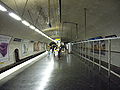
The northern track (inner loop track) to and in the Michel-Ange - Molitor station with a central platform was originally only used to park trains. After the extension of line 10, the few trains that continue to use the loop as such stop there. Trains coming from Boulogne use the southern track. The tunnel initially remains double-track and crosses the line 9 again. The two tracks only come together again shortly before the Chardon-Lagache station . Like the Église d'Auteuil, this one is single-track with only one platform, but unlike the one, it lies in a curve.
After the line has dropped to a lower level, the Mirabeau station is reached again - this time with a train stop.
Station Michel-Ange - Auteuil line 10, on the right coming from the line 9 track
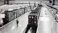
Three-track terminus at Porte d'Auteuil with Sprague-Thomson trains around 1970

MF-67 train leaving the single-track Chardon-Lagache station


Line 13

.jpg)
The northern section of Métrolinie 13 was built as line B by the company Société du chemin de fer électrique souterrain Nord-Sud de Paris (North-South), which competes with the CMP . The line from Saint-Lazare underground station to Porte de Saint-Ouen , which went into operation in 1911 , was given a branch line on January 20, 1912, which led from the La Fourche separation station to the Porte de Clichy terminus .
Porte de Clichy has a single-track loop in the shape of a tennis racket. The terminus consists of two separate, single-track stations with platforms on the outside, which are located just behind the division of the route tunnel. In 1980 the line was extended through the Paris suburb of Clichy , with the old systems being retained. The new mainline tracks lead into the loop guide or leave it, loop journeys are still possible.
The loop at the Invalides underground station is more complex . Since 1913, line 8 had already had a station west along the Rue de Constantine , which had a corresponding depth because of the nearby Seine crossing. Therefore, the tracks to the end loop of the (then) line 10, which were laid in the 1920s, were able to cross the route tunnel of line 8.
The facility, located immediately south of the Seine, was opened on November 30, 1923 as the north-western end loop of line 10. After the routing of this line was changed in 1937, it became the city-side end point of the new line 14. On November 9, 1976, line 14 was extended to the north and merged with line 13 while retaining its name. The Invalides loop lost its function as an end loop on that day, but was largely retained.
The almost rectangular shaped loop is located under the Esplanade des Invalides park north of the Invalides . The terminus at the beginning of the loop is offset to the south parallel to the station of line 8, it had a central platform on two main tracks. For the new function as a through station for Line 13, it was extended from 75 m to 115 m, only the western track still leads into the loop today. It is largely double-tracked, with a third track on its west side, which runs as an operating track to line 8 and on the first section offered a maintenance facility for the trains ( Ateliers des Invalides ). The inner loop track begins bluntly north of the station today, but soon afterwards has a track connection to the Kehrgleis, into which it joins again in the south of the loop. The latter then turns to the right to the Varenne station , to the left there is a track leading to the former terminus, whereby the loop forms a closed circle.
Conclusion

The creation of end loops arose from the original intention to use trains that were made up of a railcar (usually with only one driver's cab) and attached sidecars (→ two-axle vehicles of the Paris Métro ). With the loop run, it was possible to avoid moving a railcar (with necessarily two driver's cabs and therefore fewer passenger seats) to the other end of the train. Two-way railcars, however, had only been built in small numbers for the two short branch lines from Étoile. Soon, however, longer train sets on Line 1 led to the need to hire a second railcar per train. This railcar was initially lined up at the other end of the train, with the driver's cab in the other direction. This would have made it possible to turn around in the end stations without moving. This was practiced on Line 2 North, which had an end loop at its western end of the line, but whose trains had to butt-turn in the intermediate stations at Anvers and Bagnolet until the line to Nation was completed. After the accident in their Couronnes station , both railcars were coupled one behind the other at the start of the train for safety reasons. At that time the Endschleife Nation was already in operation, so this was no longer an obstacle. Inevitably, the CMP kept the construction of end loops on lines 3 to 6, all of which were opened before 1910. For the first time, lines 7 (at the southern end of the line) and 8 (at the northern end) were built without turning loops.
The last loop built was Invalides, after 1923 no final loops were created at Métro Paris either. However, existing loops are still used as far as operationally reasonable. It is noteworthy that the trains never change the direction of travel on Line 2.
Remarks

- ↑ The first line of the New York City Subway also ended in a loop (→ City Hall Station ), at Chicago Elevated three lines turn over the elevated railway ring "Loop"
- ^ With an interruption of several months in 1931
- ↑ Not identical to line 14, which opened in 1998
Web links
- Track network of the Paris Métro at carto.metro.free.fr
Individual evidence
- ^ Jean Tricoire: Un siècle de métro en 14 lignes. De Bienvenüe à Météor . 2nd Edition. La Vie du Rail, Paris 2000, ISBN 2-902808-87-9 , p. 128 .
- ↑ Jean Tricoire, Un siècle de métro en 14 lignes , p. 130.
- ↑ Jean Tricoire, Un siècle de métro en 14 lignes , p. 84.
- ↑ Jean Tricoire, Un siècle de métro en 14 lignes , p. 131.
- ↑ Jean Tricoire, Un siècle de métro en 14 lignes , p. 132.
- ↑ Jean Tricoire, Un siècle de métro en 14 lignes , p. 160.
- ↑ Jean Tricoire, Un siècle de métro en 14 lignes , p. 161.
- ↑ Jean Tricoire, Un siècle de métro en 14 lignes , p. 151.
- ↑ Jean Tricoire, Un siècle de métro en 14 lignes , p. 258.
- ↑ Jean Tricoire, Un siècle de métro en 14 lignes , p. 155.
- ↑ Jean Tricoire, Un siècle de métro en 14 lignes , p. 150.
- ^ Christoph Groneck: Metros in France . 1st edition. Robert Schwandl, Berlin 2006, ISBN 3-936573-13-1 , p. 16 .
- ^ Jean Tricoire: Un siècle de métro en 14 lignes , p. 166.
- ^ Jean Tricoire: Un siècle de métro en 14 lignes , p. 163.
- ↑ a b Jean Tricoire: Un siècle de métro en 14 lignes , p. 168.
- ↑ a b c Jean Tricoire: Un siècle de métro en 14 lignes , p. 183.
- ↑ Jean Tricoire: Un siècle de métro en 14 lignes , p. 185.
- ↑ Jean Tricoire: Un siècle de métro en 14 lignes , p. 182.
- ↑ Jean Tricoire: Un siècle de métro en 14 lignes , p. 191.
- ^ Jean Tricoire: Un siècle de métro en 14 lignes , p. 196.
- ^ Jean Tricoire: Un siècle de métro en 14 lignes , p. 199.
- ^ Jean Robert: Notre Métro . 2nd Edition. J. Robert, Neuilly-sur-Seine 1983, p. 71 .
- ^ Brian Hardy: Paris Metro Handbook . 3. Edition. Capital Transport Publishing, Harrow Weald 1999, ISBN 1-85414-212-7 , pp. 34 .
- ^ Jean Robert: Notre Métro , p. 243.
- ^ Jean Robert: Notre Métro , p. 34.
- ^ Christoph Groneck: Metros in France , p. 22.
- ↑ Jean Tricoire: Un siècle de métro en 14 lignes , p. 212.
- ^ Jean Robert: Notre Métro , p. 346.
- ^ A b Jean Robert: Notre Métro , p. 85.
- ^ Gérard Roland: Stations de métro d'Abbesses à Wagram . Christine Bonneton, Clermont-Ferrand 2011, ISBN 978-2-86253-382-7 , pp. 66 .
- ^ Jean Tricoire: Un siècle de métro en 14 lignes , p. 222.
- ^ Railways in Paris (Railway History Special No. 2), p. 73.
- ^ Clive Lamming: Métro insolite . 2nd Edition. Éditions Parigramme, Paris 2001, ISBN 2-84096-190-3 , pp. 129 .
- ↑ a b c Jean Tricoire, Un siècle de métro en 14 lignes , p. 268 ff.
- ^ Clive Lamming: Le métro parisien. 1900-1945 . Éditions Atlas, Évreux 2011, ISBN 978-2-7312-4739-8 , pp. 114 .
- ↑ Jean Tricoire, Un siècle de métro en 14 lignes , p. 309.