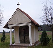
Erlingsdorf
|
Erlingsdorf
Market Pleinfeld
Coordinates: 49 ° 8 ′ 41 ″ N , 10 ° 57 ′ 27 ″ E
|
|
|---|---|
| Height : | 475 m above sea level NHN |
| Area : | 15 ha |
| Residents : | 12 |
| Population density : | 80 inhabitants / km² |
| Postal code : | 91785 |
| Area code : | 09144 |
|
Erlingsdorf
|
|
Erlingsdorf is a district of the market Pleinfeld in the central Franconian district of Weißenburg-Gunzenhausen .
The hamlet is located in the Franconian Lake District in the south of the Spalter hill country , just under 1.5 km north of the Great Bromb axis . The settlement area of the place covers one to two hectares. It can be reached via the district road WUG 18 from Stirn .
The history of Erlingsdorf began in 1721 with the Knappenhof, which was newly stocked in 1850. Later two more farms were built from it . On April 1, 1971, the former district of Allmannsdorf was incorporated into the Pleinfeld market as part of the municipal reform.
Erlingsdorf is mainly characterized by agriculture, tourism also plays a role due to the nearby Brombachsee . Today it consists of three farms, which were originally all dairy farms with additional hops . In total, the Erlingsdorf farmers own over 40 hectares of fields, meadows and forests.


