
Wet meadows near Lüderbach
|
Wet meadows near Lüderbach
|
||
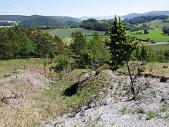
.jpg) View over the north-eastern area of the protected area. |
||
| location | Between the Ringgau districts of Rittmannshausen and Lüderbach in the Werra-Meißner district in Hesse . | |
| surface | 40.97 hectares | |
| Identifier | 1636027 | |
| WDPA ID | 163082 | |
| Geographical location | 51 ° 5 ' N , 10 ° 8' E | |
|
||
| Sea level | from around 280 m to 348.6 m | |
| Setup date | 1995 | |
| particularities | Special protection as a nature reserve and part of the Natura 2000 area " Forest southeast of Netra ". | |

The wet meadows near Lüderbach are around 40 hectares of nature reserve in the Werra-Meißner district in northern Hesse , near the state border with Thuringia . With the protection, the habitat of the rare animal and plant species occurring here is to be preserved and further developed through extensive grassland management and natural forest management.
location
The nature reserve "Feuchtwiesen bei Lüderbach" is located in the Werra-Meißner district in the municipality of Ringgau , between the places Rittmannshausen and Lüderbach . It is bounded to the northeast by Bundesstraße 7 and to the east by Kreisstraße 17 . The wet area in the valley is protected with its complex of wet meadows, sedge meadows, reeds and woody areas of humid locations as well as the dry forest areas on the vineyard.
In terms of nature , the area is assigned to the northwestern edge plate of the Thuringian Basin , which extends in the area of the Ringgau , the Wanfrieder Werrahöhen and the Gobert to Hesse. The protected area is located in the Netra-Ifta ditch which cuts through and divides the Muschelkalkplatte of the Ringgau. The geology of the area is shaped by the shell limestone of the Ringgauplateau and the Keuper . The deepest part of the protected area, at around 280 m , is in the southeast near the county road 17. The highest point is the top of the vineyard at 348.6 m .
Protected position
The "wet meadows near Lüderbach" were designated as a nature reserve in 1995 with the national number 636027 and with an area of 40.97 hectares . In the world database of protected areas, the wet meadows have the WDPA code 163082. Even before the designation, the Hessian Society for Ornithology and Nature Conservation (HGON) leased the sedge and reed beds in order to secure the parcels for nature and species protection. At the same time, the HGON operated the designation procedure it had applied for as a nature reserve and ensured that the trenches were no longer cleared so that waterlogging could slowly begin.
In 2008, the protected area was integrated into the 185.04 hectare fauna-flora-habitat area " Forest southeast of Netra ". The FFH area is characterized by a mosaic of species-rich deciduous forest communities, valuable limestone grasslands and extensively used grassland. With the number 4926-304 and a size of 185.04 hectares, it is part of the European Natura 2000 network , which aims to preserve and improve habitats that are particularly worthy of protection.
Habitats
As part of the obligation to report to the EU Commission , scientists on behalf of the Upper Nature Conservation Authority of the Kassel Regional Council prepared an opinion in May 2008 on the FFH area “Forest southeast of Netra” and the included nature reserve “Feuchtwiesen bei Lüderbach”. The area of the nature reserve was rated as a special feature because of its habitat types (LRT). The LRT 91EO "floodplain forests with black alder and ash " and the LRT 3150 "natural eutrophic lakes" are located in the valley . The investigation also confirmed concerns that the area is at risk from drying out. Of the original three ponds in the floodplain area, only one has survived. Although threatened in the long term by increasing siltation, it is important for amphibian and dragonfly protection . Of the other two, the former pond to the west is just a damp hollow with a slight flow of water. Here cane grass and swamp sedge are covered by willows . In the former easternmost pond, black alders shade the sedge population. The wet area is traversed by a small stream called the "summer stream". However, it only carries some water after prolonged and extensive rainfall.
The LRT 6210 "Natural limestone semi-dry lawns and their stages of bushing " is represented on the vineyard with the LRT subtype 6212 "Sub-Mediterranean semi-dry lawns". The semi-arid grasslands created by the use of humans and their grazing animals used to be larger. Today they are impaired by succession processes such as grassing and shrubbery. Above all, the biodiversity of the butterfly species and also the grasshopper species increases the value .
The forest area at the vineyard is assigned to the LRT 9130 " Waldmeister-Buchenwald ". It can be assumed that the forests were used as coppice or middle forest at least since the Middle Ages . The occurrence of spruce asparagus on the northern edge of the vineyard is a specialty .

Sedge and reed beds in the wet area.

View from north-westerly towards the reserve.
Erosion channel on the east side of the vineyard.
.jpg)
.jpg)
.jpg)
Tourist development
From the places Rittmannshausen and Lüderbach as well as from Kreisstraße 17, the protected area can be reached and walked on dirt roads. There is a parking lot for hikers at the sports field in Lüderbach, below the cut between the oak and vineyards. Benches are available and display boards provide information about the special features of the region.
literature
- Lothar and Sieglinde Nitsche, Marcus Schmidt: Nature reserves in Hessen, protect-experience-maintain. Volume 3, Werra-Meißner district and Hersfeld-Rotenburg district . cognitio Verlag, Niedenstein 2005, ISBN 3-932583-13-2 .
- Bureau for Nature Conservation, Ecology and Agriculture (NÖL): Basic data acquisition for FFH area 4926-304 "Forest southeast of Netra" . Regional council Kassel, Witzenhausen 2008.
Web links
Individual evidence
- ↑ Classification of natural areas according to Otto Klausing. In: Environmental Atlas Hessen; accessed on August 13, 2020.
- ↑ Ordinance on the “Feuchtwiesen bei Lüderbach” nature reserve of June 19, 1995, which came into force the day after its announcement in the State Gazette. In: State Gazette for the State of Hesse, issue no. 28/1995 of July 10, 1995, p. 2079 f.
- ↑ "Wet meadows near Lüderbach". In: World Database for Protected Areas; accessed on August 13, 2020.
- ↑ Profile of FFH area 4926-304 "Forest southeast of Netra". In: Website of the Federal Agency for Nature Conservation (BfN); accessed on August 13, 2020.
- ↑ a b Bureau for Nature Conservation, Ecology and Agriculture (NÖL): Basic data acquisition for FFH area 4926-304 "Forest southeast of Netra".
- ↑ List of habitats occurring in Germany in Appendix I of the Fauna-Flora-Habitat Directive; accessed on August 13, 2020.

Bilstein im Höllental | Blue dome | Boyneburg and Schickeberg near Breitau | Bühlchen near Weißenbach | Dreiherrenstein-Eschenberg-Kreutzerberg | Ebenhöhe-Liebenberg | Eichenberg near Frieda | Ermschwerder Heegen | Wet meadows near Lüderbach | Frankenloch near Heldra | Freudenthal near Witzenhausen | Graburg | Harthberg | Hessian Switzerland at Meinhard | Hohekopf near Großalmerode | Meissner | Iberg near Markershausen | Jestädter Weinberg | Limestone cliffs south of the Iberg | Lean lime lawn near Roßbach | Kielforst near Herleshausen | Kiesteich near Frieda | Pond under the Aue ball | Kreideberg near Ellerode | Nativity and eyeholes | Mönchesrieth near Grebendorf | Upper Niestetal | Plesse - Konstein | Headwaters of the White Gelster | Reichenbacher Kalkberge | Rhöneberg near Marzhausen | Steinbachtal and Hirschhagener ponds | Tiefenbachwiesen near Rommerode | Trimberg near Reichensachsen | Weißbachtal near Reichenbach | Werra old arm near Schwebda | Werraaltarm and Werraaue near Albungen