
Blue dome
|
Blue dome
|
||
.jpg) |
||
| location | Eschwege , Werra-Meissner district in Hesse | |
| surface | 7 ha | |
| Identifier | 1636006 | |
| WDPA ID | 81414 | |
| Geographical location | 51 ° 9 ' N , 10 ° 2' E | |
|
||
| Sea level | from 295 m to 314 m ( ø 300 m) | |
| Setup date | Under protection 1910, NSG 1969 |
|
| administration | Federal Agency for Nature Conservation | |

.jpg)
The blue dome is an elevation at 309 m above sea level. NHN in the southern urban area of Eschwege on the border with Langenhain in the Werra-Meißner district in northern Hesse . It is a designated natural monument and a nature reserve . The blue-gray color of the basalt that emerged here before it was mined probably gave the dome its name.
location
The wooded hill of the Blauen Kuppe is located in an open agricultural landscape, around three kilometers south of Eschwege, west of the state road 3424 to Langenhain. In terms of nature , the area is assigned to the Eschweger Basin in the lower Werrabergland , which belongs to the main unit group of East Hessian Uplands . The Blaue Kuppe is part of the Frau-Holle-Land Geo-Nature Park .
geography
Geological importance
The Blue Dome was once a nationally known natural phenomenon . In the 19th century in particular, the most renowned scientists of their time were concerned with how they were formed and their rocks. At that time the Neptunists and the Plutonists , also known as volcanists, argued over the correct theory of the formation of rocks. Some took the view that the rocks were formed as marine deposits , while others attributed the formation of volcanic activity. The Blauer Kuppe aroused particular interest as it provided arguments to representatives of both directions. Lorenz Oken already described minerals from the Blauer Kuppe in his General Natural History in 1839 for all classes . Even Alexander von Humboldt Blue attended summit and wrote about it in 1845 in his five-volume work Kosmos .
Today, the history of the origins of the Blauer Kuppe is considered certain: In the Miocene , a Tertiary era , glowing magma rose from the earth's interior in fracture zones . Before it reached the surface of the earth, it froze and slowly cooled. In the period that followed, a steady erosion process weathered the softer side rock around and above the basalt plug, gradually exposing it. The harder rock was ultimately left as a crest in the landscape. Today the Blauer Kuppe is at least 100 m below the surface of the earth at that time. All of the rock layers previously lying above have been removed.
The basalt rock consists of vesicle-rich, olivine- containing alkali olivine basalt with a clear flow structure. The basalt is accompanied by tuff breccias and foamy, bubble-rich slag tuffs with numerous sand and claystone floes carried along .
When the great importance of the Blauer Kuppe for science was recognized, the quarry operation , which threatened to completely erode the mountain, was stopped. The interesting contact zones between basalt lava and red sandstone as well as some basalt pillars have been preserved, which are framed by the three kettles of three more or less connected quarries. The red sandstone has become discolored by the hot lava, i.e. it has become lighter. On the walls of the quarry you can still see how sedimentary rock and igneous rock have mixed together. This change in the rock due to the glowing effect of the lava is known as contact metamorphosis , and the resulting metamorphic rock is called Buchit .
Minerals
.jpg)
After the eruption , strong fumarole activity allowed hot gas to flow through the basalt for some time and pneumatolytically deposited a number of rare minerals . Later, after further cooling, have warm waters still aragonite - and calcite - crystals formed. When the basalt of the Blauer Kuppe was mined, it came to light what nature had created millions of years ago. The well-known mineralogist Paul Ramdohr received his doctorate in 1919 on the basalts of the Blauer Kuppe, in his dissertation summarized all the minerals known from there at the time and explained their formation. To date, around 25 different minerals have been identified, some of which are kept in private collections and in the Eschwege city museum, but mainly in the mineralogical collection of the University of Göttingen .
The Eschwege city museum lists the crystallized minerals of the Blauer Kuppe as follows:
- Andradite , a mineral of the garnet group
- Representative of the apatite group
- the calcium carbonates aragonite and calcite
- the alkali feldspar orthoclase as well as augite and various other pyroxenes
- the mica - mixed crystal biotite
- the iron oxyhydroxide goethite (needle iron ore) and the iron oxides hematite and magnetite
- the iron carbonate siderite
- the hydrous zeolite mineral phillipsite
- the iron titanium oxide pseudobrookite
- Quartz , formed as amethyst or as a high-temperature modification cristobalite or tridymite
- the calcium - titanium - silicate titanite
According to statements in the museum, the cristobalite crystals are among the most beautiful in the world. Most of the finds came from open drusen . However, the sites were heavily collected and are almost extinct. Since the area was placed under protection, extraction, in whatever form, has been prohibited.
Economic use and protection
.jpg)
The current shape of the Blauer Kuppe with the two cauldron-like cavities resulted from its earlier use as a quarry since the 17th century. The basalt mining shortly before 1800 is documented, also confirmed by the fact that from 1802 scientific treatises on the Blue Dome were published. Most of the basalt knoll owned by the city of Eschwege had already been removed by the quarry when the State Geological Institute and the State Agency for Natural Monument Preservation applied for protection. By decision of the city of Eschwege, it was placed under protection in 1910. An attempt to remove gravel for road construction was repelled in 1919. Today the Blue Dome is specially protected as an extensive natural monument under the number ND 636.647 . Since 1969 it has been designated as a nature reserve with an area of 6.76 hectares. The reserve has the CDDA code 81414 and the national number 1636006.
In addition to the geological features, the plant communities of the rock and rubble corridors and the poor grasslands are important objects of protection . In the basins of the former quarry there are types of patchy, heat-loving vegetation that are endangered by dense growth and forest development. The attempt is made to keep the area free by grazing with sheep and removing bushes.
Geologically protected object
As a geotope worthy of protection , which conveys geological knowledge about the development of the earth, the abandoned quarry of the Blauen Kuppe is listed in the North Hesse landscape framework plan . As part of the Hessian Nature Conservation Act (HeNatG), so-called individual creations of nature and natural parts of the landscape, which are considered part of the geological natural heritage due to their “rarity, uniqueness or beauty”, are to be protected. The former Hessian State Office for Soil Research (HLfB) has highlighted the importance of the Blauer Kuppe, with a further five geotopes in the Kassel administrative region, of the 450 geotopes that have been recorded in Hesse.
Tourist development
- The Blaue Kuppe can be reached via cycle paths and smaller roads from the surrounding towns of Eschwege , Oberdünzebach , Langenhain and Reichensachsen .
- A circular hiking trail about one kilometer long leads around the Blaue Kuppe and offers insights into the northern and southern basins.
- The 19 km long premium hiking trail P 3 leads from Eschwege over the Blaue Kuppe to the Leuchtberge .
Picture gallery

View over the southern basin to Reichensachsen and the Wehretal
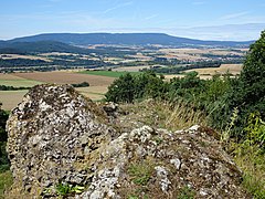
View from the Blauer Kuppe to the northwest of the Hohe Meißner and the Meißner foreland.
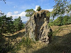
A relic of the past quarry operation in the Blauer Kuppe.
.jpg)
.jpg)
.jpg)
Others
- Just a few meters east of the Altweg Alte Mühlhäuser Straße , which also runs south of the Blauen Kuppe, is a courtyard of the same name, which is now a guest house.
- To the north-east of the NSG lies the Kleine Kuppe , 100 meters lower , which has almost the same geological structure as the Blaue Kuppe and on which the ruins of the church of the Staufenbühl deserted area are still to be found.
- Immediately to the east is the Stauffenbühl glider airfield of the Eschweger Luftsportverein eV
- The source of the Leimbach, which drains west to the weirs, rises south of the Blauer Kuppe .
- To the north-west lies the Vogelsburg domain , a Hessian fiefdom of those of Boyneburg - Bischhausen , which was actually supposed to be converted into a manor palace in 1631 according to the sketches of Landgrave Moritz von Hessen-Kassel ; but the design was never implemented.
See also
literature
- Lothar and Sieglinde Nitsche, Marcus Schmidt: Nature reserves in Hessen , Volume 3, cognitio Verlag, Niedenstein 2005, ISBN 3-932583-13-2 . P. 107 f.
- Heidrun and Friedrich Jantzen: Naturdenkmale Hessens , Landbuch-Verlag, Hannover 1985, ISBN 3-7842-0323-X . P. 59 f.
- Sparkassen-Kulturstiftung Hessen-Thüringen (Ed.): Cultural discoveries. Volume III , Höhl, Bad Hersfeld 2005, ISBN 3-934377-88-2 . P. 63
- Karl Kollmann: Frau Holle and the Meißnerland - On the trail of a myth . Historical Society of the Werraland and Werratalverein (ed.), Cordier, Heiligenstadt 2012, ISBN 978-3-939848-32-5 . P. 160 f.
- Sigmund Koritnig (Writer): On the mineralogy and geology of the area around Göttingen with the western Harz and parts of the North Hessian mountainous region , Association of Friends of Mineralogy and Geology (VFMG) eV Heidelberg (ed.), Summer conference, Göttingen 1978.
Web links
- WPDA: 81414: Blue Dome
- Friedrich Freiherr Waitz von Eschen: To the beginnings of geological research in Hessen-Kassel in the 18th century , online: Association for Hessian history and regional studies 1834 eV
- The minerals of the Blauer Kuppe on Mineralienatlas.de
- The geology of the Blauer Kuppe on www.pinatubo.net
- Blaue Kuppe, Eschwege, Hessen, Germany , website from www.mindat.org
Individual evidence
- ↑ Description of the East Hessian mountainous region in the Hesse Environmental Atlas ; accessed on November 1, 2017
- ↑ compare: Volume 1, Stuttgart, Tübingen 1845, therein: pp. 236–281 on volcanism , p. 270 on the Blauen Kuppe
- ↑ a b Heidrun and Friedrich Jantzen: Naturdenkmale Hessens , p. 59 f.
- ↑ List of the minerals of the Blauer Kuppe according to the list in the rock collection in the Eschwege city museum (status 2003)
- ↑ Blaue Kuppe, Eschwege, Hesse, Germany on www.mindat.org (mineral database); accessed on November 8, 2017
- ↑ Karl Kollmann: Frau Holle und das Meißnerland , p. 160 f.
- ↑ Marcus Schmidt: The pioneering phase of state nature conservation in North Hesse , in: Yearbook Nature Conservation in Hesse , Volume 14 (2011/2012)
- ^ Lothar and Sieglinde Nitsche, Marcus Schmidt: Nature reserves in Hessen , Volume 3, p. 107 f.
- ↑ Geologically worthy of protection objects in the landscape framework plan North Hesse on the website of the regional council of Kassel; accessed on August 25, 2018.
- ↑ Description of the premium trail P 3 on the website of the Geo-Naturpark Frau-Holle-Land; Retrieved October 26, 2017
- ↑ Staufenbühl, Werra-Meißner district. Historical local lexicon for Hesse (as of June 13, 2016). In: Landesgeschichtliches Informationssystem Hessen (LAGIS). Hessian State Office for Historical Cultural Studies (HLGL), accessed on November 1, 2017 .
- ↑ Eschweger Luftsportverein ; accessed on November 1, 2017
- ^ Vogelsburg, Werra-Meißner district. Historical local lexicon for Hesse (as of January 25, 2016). In: Landesgeschichtliches Informationssystem Hessen (LAGIS). Hessian State Office for Historical Cultural Studies (HLGL), accessed on November 1, 2017 .

Bilstein im Höllental | Blue dome | Boyneburg and Schickeberg near Breitau | Bühlchen near Weißenbach | Dreiherrenstein-Eschenberg-Kreutzerberg | Ebenhöhe-Liebenberg | Eichenberg near Frieda | Ermschwerder Heegen | Wet meadows near Lüderbach | Frankenloch near Heldra | Freudenthal near Witzenhausen | Graburg | Harthberg | Hessian Switzerland at Meinhard | Hohekopf near Großalmerode | Meissner | Iberg near Markershausen | Jestädter Weinberg | Limestone cliffs south of the Iberg | Lean lime lawn near Roßbach | Kielforst near Herleshausen | Kiesteich near Frieda | Pond under the Aue ball | Kreideberg near Ellerode | Nativity and eyeholes | Mönchesrieth near Grebendorf | Upper Niestetal | Plesse - Konstein | Headwaters of the White Gelster | Reichenbacher Kalkberge | Rhöneberg near Marzhausen | Steinbachtal and Hirschhagener ponds | Tiefenbachwiesen near Rommerode | Trimberg near Reichensachsen | Weißbachtal near Reichenbach | Werra old arm near Schwebda | Werraaltarm and Werraaue near Albungen