
Harthberg
|
Harthberg
|
||
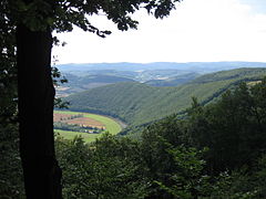
.jpg) View from the Werraaue to the steep southern slope of the Hardtberg. |
||
| location | To the right of the Werra , on the border with Thuringia , in the Werra-Meißner district in Hesse | |
| surface | 40 hectares | |
| Identifier | 1636023 | |
| WDPA ID | 163534 | |
| Geographical location | 51 ° 19 ' N , 9 ° 56' E | |
|
||
| Sea level | from 140 m to 317.6 m | |
| Setup date | December 1993 | |
| particularities | Special protection as a nature reserve and part of the Natura 2000 area "Werra- und Wehretal". | |

The Harthberg is a 317.6 m high elevation to the right of the Werra in the North Hessian Werra-Meißner district . On the steep, dry and warm slope of the Werra meander loop near Oberrieden and Lindewerra , mixed forests of sessile oaks have developed through historical cultivation as coppice . In order to preserve and protect this rare type of forest with the adjacent, herbaceous banks of the Werra, the area was declared a nature reserve in December 1993 and later anchored as part of a flora-fauna habitat area in the Europe-wide network of protected areas " Natura 2000 ".
location
The Harthberg lies in the district of Werleshausen , a district of the city of Witzenhausen in the Werra-Meißner district. It forms the western end of the Höheberg , a ridge of the Lower Werrabergland in the border area of Hesse and Thuringia . Its southern slope extends to the horseshoe-shaped Werraschleife near Oberrieden and Lindewerra in Thuringia in the Eichsfeld district .
The area belongs to the " Geo-Naturpark Frau-Holle-Land ". In terms of nature , the Hardtberg is assigned to the sub-unit "Höheberg" in the " Lower Werraland " of the " East Hessian Mountains ". In the north, the area changes into the sub-unit “Neuseesen-Werleshäuser Heights” and in the south into the sub-unit “Lindewerra-Werleshäuser Schlingen”. The Thuringian area bordering to the east is classified as " Upper Eichsfeld " in the natural spatial main unit " Northwestern edge plates of the Thuringian Basin ".
geology
The Harthberg is an extension of the red sandstone area of the Höheberg , the floe of which was lifted up into the Leinegraben in the transition area of the Saalfeld-Eichenberger fault zone . It emerged as an impact slope from the Werra, which in the Bad Sooden-Allendorfer district of Oberrieden flows in a long left bend around a circular mountain protruding from the southwest . On the steeply sloping south side of the Hardtberg, over a length of around three hundred meters in several slope sections, there are up to thirty meters thick succession of rocks from the Bernburg formation of the Lower Buntsandstein . The turbulence and the erosion force of the flowing water of the Werra undercut the rock walls and kept the bank slope steep. Nachbrechendes rock caused a relatively good digestion conditions . The Lower Buntsandstein here differs from the layers of the Middle Buntsandstein that are widespread in the district : it is rich in clay, generally rich in mica and has different sedimentary structures . The sandstones are mostly thin-plate and sometimes show ripple marks .

Outcrops of the sand-clay mixed rocks of the Lower Buntsandstein in the southeast area of the Prallhang.

The Werra undercut the embankment on the Hardtberg and thus kept the bank steep.
.jpg)
.jpg)
nature
On the steep slope facing south, forests are protected that were created as coppice forest through earlier management. The former use and the extreme site conditions have created a hawkweed sessile oak forest. This type of forest grows on areas that tend to be dry and warm and whose soils are poor in nutrients. Typical or common tree species are grape and English oak , hornbeam , small-leaved lime , service tree and wild pear . In the herbaceous layer of the light forest, dyer's gorse , cypress spurge , blue-red stone seeds , mountain sedge and black pea are represented. Several hawkweed species also find suitable growing conditions here.
The Hardtberg is also an attractive habitat for numerous bird species such as red kite , common raven , stock dove , turtledove , tawny owl , long-eared owl , green , gray , great spotted , middle and small woodpecker , gray flycatcher and treecreeper . The forest edge to Werraufer out colonize Nightingale and Marsh Tit and the reeds come reed warbler and reed bunting before. The butterflies living here include the wall fox , aurora butterfly , great ox-eye , small meadow bird , chessboard and other species.
Cultural and historical significance
The area around Lindewerra was almost always borderland. In the course of time the Thuringian and Franconian territories , the Mainz , later Prussian Eichsfelder and the Hessians came together here. In 1945 American and Soviet occupation troops occupied both banks of the Werra river and the two German states that emerged afterwards also had their borders in this area. Today only relics are left of the former " Inner German border " on the Hardtberg, with the once around one hundred meter wide aisle on which a steel mesh fence was erected and a convoy path made of concrete slabs.
In autumn 1945, the Wanfried Agreement led to a shift in the American-Soviet zone border in the Werra Valley. With it, the Americans wanted to ensure that the section of the important north-south railway connection located below the Thuringian Hanstein Castle no longer runs through Soviet occupation territory. On this approximately three-kilometer stretch of the route, there are said to have been repeated obstructions due to control harassment. With a border correction through the so-called " Wisky Vodka Treaty ", the railway line should become "Soviet-free". In exchange, the former Hessian places Sickenberg , Asbach , Vatterode , Weidenbach and Hennigerode came to Thuringia and the previously Thuringian places Werleshausen and Neuseesen and with them the Harthberg in Hesse.
The forests on the steep slope of the Hardtberg were shaped by their earlier use as coppice. The forest, like many other forests in the region, served as an oak peeling forest for the extraction of gerbera . The leather production was once until its decline after the First World War , in the nearby district town of Eschwege one of the main industries. The need for tannic acid from the oak bark was enormous. In many of the forests in the Werra Valley, which are well suited for this, the shoots of the oaks were cut just above the roots and debarked about every ten to twenty years. The trees sprout again and thus formed the multi-stemmed coppice, the structures of which have been preserved in some places to this day.
The peeled trunks could be processed into walking sticks, a branch of trade that has survived in Lindewerra to the present day. The stick-making trade has developed into a flourishing trade since 1836, so that there was soon no family in the village that was not at least partially engaged in stick-making. In the place known beyond the national borders as the “stick-making village of Germany”, for example, 30 families produced almost a million walking and supporting sticks of all kinds per year in the 1940s. Even if there are not so many today and the raw material is no longer local oak, but mostly chestnut wood, which is obtained from Spain and southern England, tens of thousands of sticks are still handcrafted here every year.

View from the cycle path near Lindewerra.
View from Lindewerra to the Harthberg and the nature reserve “Kelle-Teufelskanzel” (right in the picture).
The Hardtberg seen from the Teufelskanzel.
.jpg)

_04.JPG)
Protected position
.jpg)
With the ordinance of the Kassel regional council of December 9, 1993, which came into force on the day after the announcement in the Hessian State Gazette of December 27, 1993, the sessile oak forests of the Harthberg , which are characterized by the low forest-like use, with the adjoining perennial Werraufer were declared a nature reserve. The protected area with a size of 40 hectares has the national identifier 1636023 and the WDPA code 163534.
As one of many sub-areas, the “Harthberg” nature reserve was integrated into the “Werra- und Wehretal” fauna-flora-habitat area, with the number 4825-302 and the WDPA code 555520187, and is thus part of “Natura 2000 ”, the Europe-wide network of protected areas for the conservation of endangered habitats and species. With an area of around 24,000 hectares, the largest FFH area in the Werra-Meißner district is primarily intended to protect the bat species Bechstein's bat and great mouse- eared bat, as well as to protect the large contiguous beech forests with near-forest grassland and adjacent orchards. Legal protection took place in January 2008 with the "Ordinance on Natura 2000 areas in Hesse". Because of the occurrence of many biotopes classified as valuable , the Werra valley in connection with the Hohen Meißner and Kaufungen forests is nationwide a "hotspot" of biodiversity .
On the Thuringian side, the nature reserve and Natura 2000 area " Kelle - Teufelskanzel " borders directly on the Harthberg. In the 200 hectare area, deciduous forests are protected that have emerged from former coppice forests and are mostly classified as habitat type bedstraw-oak-hornbeam forest , as well as silicate rocks and orchards. The "Kelle-Teufelskanzel" protected area is located within the EU bird sanctuary 4626-420 "Werrabergland southwest of Uder" and the "Obereichsfeld" nature reserve.
The protected areas "Harthberg" and "Kelle-Teufelskanzel" are of particular importance in the biotope network of the " Green Belt ", which was declared a national natural monument by the decision of the Thuringian Parliament on November 9, 2018 .
Tourist development

The protected area can be accessed on existing forest roads. Some marked hiking trails lead to the lookout points "Lindewerrablick", "Zweiburgenblick" and " Teufelskanzel ". At the foot of the Harthberg, the natural Werratal cycle path runs between Lindewerra and Werleshausen.
literature
- Lothar and Sieglinde Nitsche, Marcus Schmidt: Nature reserves in Hessen, protect-experience-maintain. Volume 3, Werra-Meißner district and Hersfeld-Rotenburg district . cognitio Verlag, Niedenstein 2005, ISBN 3-932583-13-2 .
- Adalbert Schraft: GeoTours in Hessen - Geological forays through the most beautiful regions of Hessen. Volume 3 - East Hessian Buntsandstein-Bergland and Werra-Meißner-Bergland . Hessian State Office for Nature Conservation, Environment and Geology, Wiesbaden 2018, ISBN 978-3-89026-384-7 .
- Holm Wenzel, Werner Westhus, Frank Fritzlar, Rainer Haupt and Walter Hiekel: The nature reserves of Thuringia . Weissdorn-Verlag, Jena 2012, ISBN 978-3-936055-66-5 .
Web links
Individual evidence
- ↑ Classification of natural areas according to Otto Klausing. In: Environmental Atlas Hessen; accessed on June 30, 2020.
- ↑ Holm Wenzel, Werner Westhus, Frank Fritzlar, Rainer Haupt and Walter Hiekel: The nature reserves of Thuringia. P. 448 f.
- ↑ From Lindewerra to the Teufelskanzel and outcrops on the Werra bank. In: Adalbert Schraft: GeoTouren in Hessen - Geological forays through the most beautiful regions of Hessen. P. 608 f.
- ^ A b Sieglinde and Lothar Nitsche: Nature reserves in the Werra-Meißner district. In nature reserves in Hessen, protect-experience-care. Volume 3, p. 124 f.
- ↑ Karl-Heinz Binzer: The Eschweger Lohgerber. Leather from Eschwege - From the history of a lost craft. Self-published by the Eschwege History Association, 1992.
- ↑ Oliver Lück: "The stick maker from Lindewerra". In: Spiegel online; accessed on June 30, 2020.
- ^ Ordinance on the "Harthberg" nature reserve of December 9, 1993. In: State Gazette for the State of Hesse, issue no. 52/1993 of December 27, 1993, p. 3245 f.
- ↑ "Harthberg". In: World Database for Protected Areas; accessed on June 30, 2020.
- ↑ "Werra and Wehretal". In: World Database for Protected Areas; accessed on June 30, 2020.
- ^ Ordinance on the Natura 2000 areas in Hesse. In: Law and Ordinance Gazette for the State of Hesse. Part I - No. 4, dated January 16, 2008.
- ↑ Profile of the FFH area 4825-302 Werra and Wehretal. In: Website of the Federal Agency for Nature Conservation (BfN) ; accessed on June 30, 2020.
- ↑ Hotspots of Biodiversity. In: Website of the Federal Agency for Nature Conservation (BfN); accessed on June 30, 2020.
- ↑ "Trowel Devil's Pulpit". In: World Database for Protected Areas; accessed on June 30, 2020.
- ↑ Profile of the FFH area 4625-303 "Kelle-Teufelskanzel". In: Website of the Federal Agency for Nature Conservation (BfN) ; accessed on June 30, 2020.
- ↑ "The Green Belt Thuringia - National Natural Monument". On the website of the Thuringian Ministry for the Environment, Energy and Nature Conservation ; accessed on June 30, 2020.

Bilstein im Höllental | Blue dome | Boyneburg and Schickeberg near Breitau | Bühlchen near Weißenbach | Dreiherrenstein-Eschenberg-Kreutzerberg | Ebenhöhe-Liebenberg | Eichenberg near Frieda | Ermschwerder Heegen | Wet meadows near Lüderbach | Frankenloch near Heldra | Freudenthal near Witzenhausen | Graburg | Harthberg | Hessian Switzerland at Meinhard | Hohekopf near Großalmerode | Meissner | Iberg near Markershausen | Jestädter Weinberg | Limestone cliffs south of the Iberg | Lean lime lawn near Roßbach | Kielforst near Herleshausen | Kiesteich near Frieda | Pond under the Aue ball | Kreideberg near Ellerode | Nativity and eyeholes | Mönchesrieth near Grebendorf | Upper Niestetal | Plesse - Konstein | Headwaters of the White Gelster | Reichenbacher Kalkberge | Rhöneberg near Marzhausen | Steinbachtal and Hirschhagener ponds | Tiefenbachwiesen near Rommerode | Trimberg near Reichensachsen | Weißbachtal near Reichenbach | Werra old arm near Schwebda | Werraaltarm and Werraaue near Albungen