
Jestädter vineyard
|
Jestädter vineyard
|
||
.jpg) |
||
| location | West of Jestädt in the Werra-Meißner district in Hesse | |
| surface | 60.19 hectares | |
| Identifier | 636.008 | |
| WDPA ID | 82016 | |
| Geographical location | 51 ° 13 ' N , 10 ° 0' E | |
|
||
| Sea level | from 150 m to 200 m | |
| Setup date | First protection status as a natural monument in 1924, as a nature reserve in 1978 | |
| particularities | Special protection as a natural monument, as a nature reserve and as part of the Natura 2000 area "Jestädter Weinberg / Werraaltarm and -aue near Albungen". | |

The Jestädter Weinberg is a Zechstein ridge on the right bank of the Werra in the north Hessian Werra-Meißner district , whose visible dolomite rocks with their holey, weathered surface shape the landscape. As early as 1924, all rock areas were designated as natural monuments in a first protection ordinance. The area has been a nature reserve since 1979 and a fauna-flora-habitat area in the Natura 2000 protected area system, which is networked across Europe . With water bodies, open areas, hedges and forests, the protected area encompasses very different habitats and thus has a wealth of structures that is home to a multitude of plant and animal species.
Geographical location
The Jestädter Weinberg extends to the right of the Werra at the exit of the Eschweg basin . It lies in the districts of My Harder hamlet Jestädt and Eschweger district Albungen . In terms of nature , the protected area is assigned to the edge areas of the “Albunger Werra Valley” , the “Schwebda-Jestädter Werraaue” and the “Southern Gobert foreland” , which belong to the lower Werrabergland in the main unit group of the East Hessian Uplands .
Protected position
The Jestädter Weinberg and the western slope of the Fürstenstein, which adjoins it to the north, received their first protection status due to their geological and botanical characteristics as early as 1924. The designation as a protected extensive natural monument followed in October 1937 and in October 1978 the area was declared a nature reserve. As a natural monument, the "Jestädter Weinberg" has the number ND 636.605 and as a nature reserve with an area of 60.19 hectares, the national number 636.008 and in the world database for protected areas the WDPA ID code 82016.
With the adjoining nature reserve Werraaltarm and Werraaue near Albungen to the west , the vineyard forms a fauna-flora-habitat area in the Natura 2000 network of protected areas under the name “Jestädter Weinberg / Werraaltarm and Werraaue near Albungen”. The FFH area has the area number 4725-302 and covers an area of 86.21 hectares. The establishment of the area boundaries and the conservation goals took place in March 2008. Both parts are separated by the embankment of the railway line between Bebra and Göttingen and the Werra valley cycle path built in the 1870s .
geology
.jpg)
.jpg)
In the area of the protected area, the Werra flows from the west, in a narrowed section of the valley to the north. The Werra enters the area of paleozoic rocks that come to light in the area between Eschwege and Witzenhausen . This bulge is considered to be a remnant of the previously connected Variscan mountain range from the Rhenish Slate Mountains in the southwest to the Harz in the northeast. As the oldest rock layer occur shales of Devonian on the hillside below the prince stone and at the western foot of the vineyard. The folded and kinked Devonian slates are discordantly overlaid by layers of the Zechstein formation. Zechstein conglomerate , copper slate and the wall-like Zechstein limestone are represented by the deposits of the Lower Zechstein . Further to the east, the Zechstein strata that emerge on the steep slope are younger until they are overlaid by the red sandstone at Jestädt . The rocky zones sloping down the slope are formed one after the other by the up to 50 m thick deposits of the older gypsum , then by the reef-like protruding cliffs of the main dolomite that dominate the vineyard .
For the biologist Dr. Helmut Sauer from Eschwege, who committed himself in the 1970s to designating the site as a nature reserve, the Jestädter Weinberg is geoscientific as an area of outstanding specialty:
"The valley slope on the right bank of the Werra offers an almost complete profile of the Zechstein formation and also provides clear information about geological events on the eastern edge of the paleozoic bulge."
nature

Between Jestädt and Albungen, the steep slopes of the Jestädter Weinberg, the wooded slope below Fürstenstein Castle and the Werra and its floodplain are part of the nature reserve.
Vineyard
On the south-facing slope of the vineyard, extreme micro-climatic conditions prevail with large daily and annual temperature fluctuations. The warming of the soil surface can reach considerable values. Among the many areas that were previously used as vineyards in Werraland, the Jestädter Weinberg had one of the most favorable locations and offered the best conditions for viticulture. Vines are said to have been tended in Jestädt as early as the first millennium. It can be proven that in 1738 there were eight winemakers in the village who cultivated the vineyards belonging to the manor house. When good vintage wines were produced less and less, cultivation declined towards the end of the 18th century and was finally abandoned. Peronospora disease, which was triggered by an algae fungus introduced from America in the 1870s, may have contributed to the final end . The vines that survived in the bushes spread over the slope are still reminiscent of the earlier viticulture.
Other relics that were previously planted in the vineyards as aromatic , medicinal or ornamental plants and have survived to this day are hyssop , rue , houseleek and blue iris . Vineyard crowds , Schopfträubel and vineyard leeks have survived from the vegetation accompanying the vineyards . Beside them there are numerous heat-loving plants that have penetrated without human intervention and are native to the sub-Mediterranean area.
The attempt to continue to use part of the slopes as orchards or gardens after the abandonment of viticulture was soon abandoned in most cases. From such gardens are overgrown the lilac hedges and vinegar trees remained, to some garden refugees .
Due to different uses and various interventions by humans, the vegetation today consists of a variety of plants. Mulberry trees can still be found on the vineyard, which were planted in the 1930s for the breeding of silkworms. In the western area, juniper stands have developed on the dry grassland, which used to be grazed, and occupy a larger area on the vineyard.
The grasslands on the lime-rich subsoil and in the heat-favored location of the vineyard are considered priority habitats according to the fauna-flora-habitat directive. Remarkable plant species can be found on the dry site, which is overgrown with juniper and bushes. Orchids such as large two-leaf orchid , three-tooth orchid , helmet orchid , flywort and bee garwort . In the limestone cliffs, warmth-loving plants such as brown-stemmed striped fern and rue settle on projections and on the cavernous walls . Conspicuous earth lichens can be found in open areas of the dry grass on stony ground. In order to ensure the survival of these species, the slopes were largely cleared of dense woody growth between 2000 and 2003.
The light wood structure of the flower-rich fringes create an attractive habitat for insects, birds and small organisms. The species-rich butterfly fauna is remarkable. As part of the obligation to report to the EU Commission, scientists prepared an opinion on the FFH area on behalf of the Upper Nature Conservation Authority of the Kassel Regional Council in 2003. Part of the investigation was the recording of butterflies on the limestone grasslands. A total of 36 butterfly and ram species were found in the area. It is true that relatively undemanding butterfly species dominate large parts of the protected area. But with comma butterfly , spring fritillary Golden Eight , dark green fritillary , mustard white butterfly and the ZYGAENA CARNIOLICA occur in ways that after the " Red List Hessen" are considered endangered.

Dry grass area with juniper stands in the western area of the vineyard.

Through extensive grazing with sheep, the character of the lean lawn is to be retained in the future.
.jpg)
.jpg)
Fürstenstein
As old pictures show, the wooded western slope of the Fürstenstein was still free of forests at the beginning of the 20th century. The steeply sloping surface served as pasture for cattle and carried a dry, limestone lawn. After the decline in sheep farming, the slopes were no longer grazed and a light bush forest expanded. Individual areas were also afforested with pine trees. As evidence of the former pasture use, some hat trees , mostly old gnarled oaks, have survived in the now closed forest. Its undergrowth is particularly attractive due to the spring flowers such as lark spur and wild garlic .
The model according to the fauna-flora-habitat guidelines for the forest community is the protection of the near-natural and structurally rich stands with the hat trees occurring as a special component. The standing and lying dead wood, the cave trees and the tree species typical of the habitat in their various stages of development and age should be preserved.

View from the summer rental to the western slope and Fürstenstein Castle.
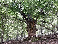
Hutebaum on the slope of the Fürstenstein.

.jpg)
Werra and their floodplain

In the narrow floodplain between the slopes and the Werra, areas are used for agriculture as fields or meadows. Near-natural vegetation remains limited to the waters and their banks. The course of the Werra is accompanied by fringes of willow bushes and perennial thickets, which are assigned to habitat type 6431 “Moist tall herbaceous vegetation on the banks of water”. In addition to reed bed species such as reeds and reed grass , annual wild herbs such as goosefoot and log species have a high proportion. The tall glossy message is particularly eye-catching. The penetration of halophilic (ie “salt-loving”) plants along the Werra is noticeable , caused by the pollution of the river with sewage from the potash works in the Thuringian-Hessian border area.
In the area along the protected area, the Werra's bed was partially relocated in the 1870s. During the construction of the railway line from Bebra to Göttingen, the straightening was intended to avoid the erection of two bridges over the former river bend.
The "Jestädter See" is a relic of gravel mining and is an artificially created, standing body of water . With the intensive expansion of leisure facilities on the large gravel lakes upstream, many water birds were driven into the floodplain. The former importance for the gravel pond on the vineyard, away from the traffic routes, as a breeding, resting and feeding area for birds returned.
The basic data collection created in 2003, with the investigation of the waters and their banks at the vineyard and in the neighboring nature reserve “Werraaltarm and Werraaue bei Albungen”, included the count of dragonflies occurring in the area . Also with the aim of getting a better assessment of the habitat type 3150 “Nutrient-rich lakes and ponds with underwater plants”. The scientists were able to prove the occurrence of 26 species in the area. The majority were relatively undemanding and common species. In addition, the common winter dragonfly , large and small shell-eye , bat-azure maiden , little mosaic maiden and southern blue arrow were also found in Hesse .
Tourist development
The Werra valley cycle path , which offers good views of the slopes, runs past the nature reserve to the left of the Werra. To the right of the Werra, between the slopes of Weinberg and Fürstenstein and the Aue, another natural cycling and hiking trail leads through the protected area.

View of the vineyard from the Werra Valley cycle path

Information board on the FFH area on the vineyard.
.jpg)
.jpg)
literature
- BIOPLAN Marburg: Basic data acquisition for FFH area No. 4725-302 "Jestädter Weinberg / Werraaltarm and -aue bei Albungen" . Prepared on behalf of the Kassel Regional Council. Status: November 2003, 1st amendment August 2004.
- Lothar and Sieglinde Nitsche, Marcus Schmidt: Nature reserves in Hessen. Volume 3: Werra-Meißner district and Hersfeld-Rotenburg district. cognitio Verlag, Niedenstein 2005, ISBN 3-932583-13-2 .
- Helmut Sauer: Werraaue and valley slopes on the Jestädter Weinberg and Fürstenstein near Eschwege (Nordhausen). In: Natural History Museum in the Ottoneum in Kassel (Hrsg.): Philippia. Book III, Kassel 1977, ISSN 0343-7620 , pp. 224-238 ( PDF on ZOBODAT ).
- Adalbert Schraft: Unterwerra-Sattel and Albung Paleozoic between Eschwege-Albungen and Meinhard-Jestädt. In: GeoTouren in Hessen - Geological forays through the most beautiful regions of Hessen. Volume 3 - East Hessian Buntsandstein-Bergland and Werra-Meißner-Bergland. Hessian State Office for Nature Conservation, Environment and Geology, Wiesbaden 2018, ISBN 978-3-89026-384-7 , p. 563 f .
Web links
Individual evidence
- ↑ Classification of natural areas according to Otto Klausing in the Hessen Environmental Atlas at atlas.umwelt.hessen.de ; accessed on September 24, 2018.
- ↑ Marcus Schmidt: The pioneering phase of state nature conservation in North Hesse. In: Yearbook Nature Conservation in Hessen. Volume 14, 2011/2012. nw-fva.de accessed on September 24, 2018.
- ↑ Ordinance on the "Jestädter Weinberg" nature reserve of October 3rd, 1978 in the State Gazette for the State of Hesse No. 44/1978.
- ↑ Jestädter vineyard in the world database for protected areas; accessed on September 24, 2018.
- ↑ Profile of the FFH area on the website of the Federal Agency for Nature Conservation (BfN); accessed on September 24, 2018.
- ↑ Ordinance on the Natura 2000 areas in Hesse in the Law and Ordinance Gazette for the State of Hesse, Part I, No. 4, of March 7, 2008.
- ↑ FFH area “Jestädter Weinberg / Werraaltarm u. -aue bei Albungen “in the world database on protected areas; accessed on May 4, 2019.
- ↑ Helmut Sauer: Werraaue and valley slopes on the Jestädter Weinberg and Fürstenstein. 1977, p. 224 f.
- ^ Jestädt, Werra-Meißner district. In: Historical local dictionary. accessed on May 4, 2019.
- ↑ Helmut Sauer: Werraaue and valley slopes on the Jestädter Weinberg and Fürstenstein. 1977, p. 226 f.
- ↑ List of habitats occurring in Germany in Appendix I of the Fauna-Flora-Habitat Directive ; accessed on September 24, 2018.
- ↑ Basic data acquisition for the FFH area "Jestädter Weinberg / Werraaltarm and -aue near Albungen", p. 12 f; accessed on September 24, 2018.
- ^ Lothar and Sieglinde Nitsche, Marcus Schmidt: Nature reserves in Hessen. Volume 3, 2005, pp. 130 f.
- ↑ Helmut Sauer: Werraaue and valley slopes on the Jestädter Weinberg and Fürstenstein. 1977, p. 228 f.

Bilstein im Höllental | Blue dome | Boyneburg and Schickeberg near Breitau | Bühlchen near Weißenbach | Dreiherrenstein-Eschenberg-Kreutzerberg | Ebenhöhe-Liebenberg | Eichenberg near Frieda | Ermschwerder Heegen | Wet meadows near Lüderbach | Frankenloch near Heldra | Freudenthal near Witzenhausen | Graburg | Harthberg | Hessian Switzerland at Meinhard | Hohekopf near Großalmerode | Meissner | Iberg near Markershausen | Jestädter Weinberg | Limestone cliffs south of the Iberg | Lean lime lawn near Roßbach | Kielforst near Herleshausen | Kiesteich near Frieda | Pond under the Aue ball | Kreideberg near Ellerode | Nativity and eyeholes | Mönchesrieth near Grebendorf | Upper Niestetal | Plesse - Konstein | Headwaters of the White Gelster | Reichenbacher Kalkberge | Rhöneberg near Marzhausen | Steinbachtal and Hirschhagener ponds | Tiefenbachwiesen near Rommerode | Trimberg near Reichensachsen | Weißbachtal near Reichenbach | Werra old arm near Schwebda | Werraaltarm and Werraaue near Albungen