
Gölsental


The Gölsental is a valley in the Lilienfeld district in Lower Austria, through which the Gölsen River flows .
geography
The approx. 600 m high court mountain forms the beginning of the Gölsental in the east. From there it runs 19 km westwards until it finally flows into the Traisental and the Gölsen flows into the Traisen. Geographically, the Gölsental is the border between the Vienna Woods and the Gutenstein Alps . From a geological point of view, it forms the border between the Wienerwald-Sandtein = ( north of the Gölsen ) and the pre-Alpine limestone zone ( south of the Gölsen ).
This explains the diverse mountain shapes in the region. In the north the gently rolling hilltops of the Vienna Woods, which in the south contrast with the steep pyramids of the foothills of the Alps. Since they rise in a staggered manner, the mountains on both sides of the Gölsen are excellent vantage points, especially in the direction of the Danube basin and the Waldviertel . On a clear day you can even see as far as the Bohemian-Moravian border mountains of the Czech Republic .
To the east of the Gölsental, the Triestingtal connects to the Richtberg . The highest mountain is the Kirchenberg (924 m) near Hainfeld, other mountains worth mentioning are the Vollberg (624 m) also located near Hainfeld and the Staff (885 m) near St. Veit.
The climate is shaped by the northern congestion of the Alps. As a result of the geological conditions already mentioned, there is a rich vegetation, especially mixed forests dominate the landscape. The actual Gölsen arises a few kilometers into the valley in Hainfeld through the confluence of the Ramsaubach - a clear mountain stream - and the Fliedersbach coming from the Vienna Woods.
The largest communities in Gölsental are the town of Hainfeld and the St. Veit market , another important community is Rohrbach an der Gölsen .
history
Prehistory & Antiquity
During the Mesozoic period , the entire area of today's Gölsental, together with other large areas of land, lay at the bottom of the oceans, as found fossils of ammonites prove. Stone Age tools (a stone hammer, a mortar and a stone club ) discovered at St. Veiter Staff in the early 20th century also prove that anatomically modern humans ( Homo sapiens ) settled in this area early on.
During antiquity, the Gölsental was part of the Celtic kingdom of Noricum . Celtic settlements and graves on the Vollberg are documented for this period. With the establishment of the Roman province of Noricum in 15 BC. Under Emperor Augustus the valley became part of the Roman Empire . With the imperial reforms of Emperor Diocletian , the province of Noricum was split into Noricum Ripense (Ufernorikum, meaning the Danube bank) and Noricum Mediterraneum (inland Noricum ), with the Gölsental now belonging to the former. However, the ancient history of the valley itself is obscure, there were simply no important settlements in the area, as the Roman centers were all on the Danube.
After the fall of Rome during the Great Migration , Heruli, Rugians, Lombards, Slavs and the Avars all moved through Lower Austria, but none of these tribes got lost on the banks of the Gölsen . This "historical non-existence" was only to change with the emergence of Ostarrîchis in the High Middle Ages .
middle Ages
In the Middle Ages, an important traffic route ran through the Gölsental from the Richtberg over the Vollberg and then over the mountain ridge further west, also the Via Sacra , a centuries-old pilgrimage from Vienna to Mariazell . In his description of the network of Roman military roads in Lower Austria (Jahrbuch f. Landeskunde v. Lower Austria, 1928), Erich Polaschek even included a Roman side road running through the Gölsen and Triesting valleys. But all in all, the Gölsental was a wild area with dense forests and a wide, marshy valley floor. The latter is also the explanation why Rohrbach is so far away from today's main road .
The early settlement of the Gölsental
In the early 9th century, Slavic farmers had settled in the area of the Türnitz Traisen , who had followed them to the west as subjects of the Magyars . From today's place names one can assume that some of these farmers also lived temporarily in the Gölsen and Triestingtal valleys. Examples are the names of the two rivers Triesting ( trusti = pipe ) and Gölsen ( golcana = (the) chuckling end ).
Another terrible raid by the Magyars before their final defeat in 955 in the battle of the Lechfeld had depopulated large parts of the Mostviertel . In 976 the Babenberg Luitpold was made the first margrave of Austria by Emperor Otto II . According to older sources, Margrave Leopold I called Franconia to colonize the Gölsental valley. They were the first off-duty farmers in this area who were liable to pay income. Bavarian colonists followed later, who finally prevailed, which is why people in Gölsental today (just like all Eastern Austrians) speak a Central Bavarian dialect.
One of the first early settlements was the village of Hagenfelt . This first grove stood at the point where the city's main square is today. Further to the west, the area was unsuitable for a local foundation because of the swamps there. Around this time, the first significant building, the Veste Hainfeld , the seat of the Lords of Hainfeld, can be identified. They were the earliest verifiable noble family in Gölsental. However, they died out with the death of Richard the Younger von Hainfeld at the end of the 12th century / beginning of the 13th century.
The Gölsental under the Otakars

The daughter of Margrave Leopold II , Elisabeth of Austria, married Margrave Ottokar II of Styria in 1085 . Leopold had given her the area between the Vienna Woods and the Pre-Alps as a dowry. The Traisen and Gölsental were now owned by the Styrian rulers for the next 107 years , but the valley owes a lot to them today. The Otakare decisively pushed ahead with the clearing and urbanization of the Gölsental. For this purpose they sent their ministerials , aristocratic followers, to Gölsental, who were supposed to supervise the clearing and administer the area in the spirit of the Traungau people . Through their function as clearing managers, these ministerials quickly gained influence, income and goods. The most famous of these new ministerial gentlemen in the valley was Friedrich von Hohenstaff , who built his fortress, the Staffburg, around 1100 am Staff (then known as Hohenstaff ) near St. Veit . From Hohenstaff Castle he and his descendants the Hohenstaffer administered the area entrusted to them. From the Hohenstaffer family, two other noble families that were very important for the Gölsental, namely the Altenburger and the Hohenberger, were to emerge later.
Margrave Ottokar II. Von Steier deserves a special place in the local history through the foundations of churches (-> Otakarian church foundations ) in St. Veit and Hainfeld. On the banks of the Gölsen, below the Staffkogel on which Friedrich had built his castle, Ottokar II founded a church around 1120, consecrated to St. Vitus . Friedrich von Hohenstaff became the first steward of this church. In the following time a small street settlement developed around the church, St. Veit an der Gölsen was born. During the same period in Hainfeld, the margrave lifted the old castle of the Lords of Hainfeld and founded a church of St. Andrew the Apostle in its place . The churches were initially affiliated with the parish of Pyhra . 1161 handed over Ottokar III. the two margrave churches in Hainfeld and St. Veit at Göttweig Abbey in exchange for land in Alkersdorf .
The rule of the Otakare over the Gölsental ended in 1192 when, after the death of the last Styrian Duke Ottokar IV., The Gölsental and other areas fell back to the Babenbergs in accordance with the Georgenberger Handfeste .
Modern times
During the 18th century the Gölsental was a popular destination for people from Vienna and St. Pölten. Hainfeld in particular was known as a summer retreat and was much visited. In the age of the beginning industrialization, numerous weir systems and works streams for the operation of hammer and sawmills were built along the valley .
Leisure and Tourism

Thanks to its mountains, the Gölsental is a traditional hiking region with numerous, well-marked hiking trails and huts. These huts for entertaining guests are always open on weekends. Among other things, the three-hut hiking trail on the Kirchenberg, which consists of the Liasenböndl hut (at 640 meters), the Hainfelderhütte (at the top at 924 meters) and the Lindensteinhütte (at 690 meters), is popular. Other popular routes are the hiking trail on the Staff to the local refuge of the Naturfreunde or northwest of Rohrbach am Bergrücken to the Kuckubauerhütte (better known by its name in the local dialect Gugabauerhittn ).
In addition to the range of hiking trails, there are also several museums and other leisure activities such as B. the Hainfelder Stadtbad or the Kneipp water treading facility on the Kirchenberg.
Economy and Infrastructure
Agriculture

The Gölsental is a traditional fruit-growing region in which mainly apples and pears are cultivated. Some of the harvested fruit (also windfalls) is processed into must by pressing at home , which is why it is also part of the Lower Austrian Mostviertel . Other important branches of local agriculture include cattle breeding ( Fleckvieh ) and extensive forestry . Numerous farms line the edges of the valley, especially north of the Gölsen on the Wienerwald hills.
Industry
One of the largest employers in Gölsental is Schmid Schrauben GmbH, the only screw factory in Austria, with around 200 employees. It is located east of Hainfeld and is a leader in the field of screw production .
traffic
The B18 runs through the entire Gölsental and connects it with Mariazeller Straße B 20 in the Traisental in the west and with Leobersdorf and the Triestingtal in the east. The ÖBB operates the Leobersdorfer Bahn in the region , which connects all the larger towns in the Gölsental directly with the Traisental and the state capital St. Pölten . The terminus today is the train station in Hainfeld, but until 2004 the train also continued over the Richtberg into the Triestingtal and was thus a direct southern connection to Vienna . In addition to the B18 and the Leobersdorfer Bahn, there is also a cycle path that runs continuously from Rechtsberg to Traisen .
gallery

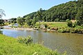
The Gölsental shortly after Rohrbach towards Traisen

Gölsental shortly after Rohrbach
The Gölsen shortly before St. Veit

The eastern Gölsental as seen from the Staff ( mountain near St. Veit ). In the picture the places Rainfeld , Bernreit and Rohrbach at the very back

Restaurant on the Rechtsberg


literature
- Josef Greimel: Hainfelder Heimatkunde, 1st issue , 1924
- Hans Reiss: Guide from Hainfeld to the area , 1925
- Hans Reiss: Our hometown Hainfeld through the ages , 1928
- Bernhard Baumgartner: 400 years of Markt St. Veit 1588-1988 , 1988
- Eleonora Auer: Rohrbacher Heimatbuch , 1992
- Karl Jägersberger: Becoming and growing the city of Hainfeld , 2004
- Margarete Kowall, Brigitte Karner-Fritz: Das Gölsental , 2012
Remarks
- ↑ Archived copy ( Memento of the original from April 2, 2015 in the Internet Archive ) Info: The archive link was inserted automatically and has not yet been checked. Please check the original and archive link according to the instructions and then remove this notice.
Coordinates: 48 ° 3 ' N , 15 ° 44' E