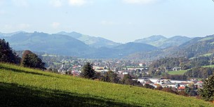
St. Veit an der Gölsen
|
market community St. Veit an der Gölsen
|
||
|---|---|---|
| coat of arms | Austria map | |
|
|
||
| Basic data | ||
| Country: | Austria | |
| State : | Lower Austria | |
| Political District : | Lily field | |
| License plate : | LF | |
| Surface: | 78.19 km² | |
| Coordinates : | 48 ° 3 ' N , 15 ° 40' E | |
| Height : | 369 m above sea level A. | |
| Residents : | 3,906 (January 1, 2020) | |
| Postal code : | 3161 | |
| Area code : | 02763 | |
| Community code : | 3 14 12 | |
| NUTS region | AT122 | |
| Address of the municipal administration: |
Kirchenplatz 1 3161 St. Veit an der Gölsen |
|
| Website: | ||
| politics | ||
| Mayor : | Johann Gastegger ( SPÖ ) | |
|
Municipal Council : ( 2020 ) (23 members) |
||
| Location of St. Veit an der Gölsen in the Lilienfeld district | ||
 St. Veit an der Gölsen |
||
| Source: Municipal data from Statistics Austria | ||
St. Veit an der Gölsen (also Sankt Veit an der Gölsen ) is a market town with 3906 inhabitants (as of January 1, 2020) in the Lilienfeld district in Lower Austria .
geography
St. Veit an der Gölsen is located in the Gölsental in the Lilienfeld district in Lower Austria.
The area of the market town covers 78.19 square kilometers. 56 percent of the area is forested.
Community structure
The municipal area includes the following 14 localities or cadastral communities of the same name (population in brackets as of January 1, 2020):
- Differing KG names are mentioned in the second position.
- Ausser-Wiesenbach or Ausserwiesenbach (265) including Brillergraben
- Inner-Wiesenbach or Innerwiesenbach (27) including the Neutaler, Schindeltal and Steigengraben
- Kerschenbach (190)
- Kropfsdorf (153)
- Maierhoefen or Ma y erhöfen (75)
- Upper region (124)
- Pfenningbach (66)
- Rainfeld (791)
- St. Veit an der Gölsen (746)
- Schwarzenbach an der Gölsen or Schwarzenbach (416)
- Steinwandleiten or Steinwandleit h en (492) including the lime mill
- Traisenort (93)
- Wiesenfeld (410)
- Watch (58)
Neighboring communities
In the St. Pölten-Land district :
history

In ancient times, the area of today's St. Vitus was part of the Celtic Kingdom of Noricum and the later Roman province of the same name.
The actual place arose with the founding of the Church of St. Vitus by the Traungau Margrave Ottokar II of Styria, around which a small street settlement later developed. At that time the Gölsental was in the possession of the Styrian rulers, as the area between the Vienna Woods and the Pre-Alps was given as a dowry by Margrave Leopold II to his daughter Elisabeth of Austria when she married Ottokar II. The followers of Ottokar II from the ministerial families Hohenstaff-Altenburger-Hohenberger received the castles near Hainfeld and St. Veit. Among other things, you were the clearing manager for the urbanization of the Gölsental and quickly gained influence. It is documented that around 1100 Friedrich von Hohenstaff , by the name of Vogt of the Church of St. Vitus, built the Staffburg on St. Veiter Staff on the Staffspitze , on which the Hohenstaff family was to reside until 1202.
The rule of the Traungau over St. Veit ended in 1192 when, after the death of the last Styrian Duke Ottokar IV, the Gölsental and other areas fell back to the Babenbergs according to the Georgenberger Handfeste .
Population development
|
|
politics
The municipal council has 23 members.
- With the municipal council elections in Lower Austria in 1990, the municipal council had the following distribution: 15 SPÖ, 7 ÖVP, and 1 Greens.
- With the municipal council elections in Lower Austria in 1995, the municipal council had the following distribution: 13 SPÖ, 8 ÖVP, and 2 Greens.
- With the municipal council elections in Lower Austria in 2000, the municipal council had the following distribution: 14 SPÖ, 8 ÖVP, and 1 FPÖ.
- With the municipal council elections in Lower Austria in 2005 , the municipal council had the following distribution: 15 SPÖ and 8 ÖVP.
- With the municipal elections in Lower Austria in 2010 , the municipal council had the following distribution: 15 SPÖ, 7 ÖVP, and 1 FPÖ.
- With the municipal council elections in Lower Austria in 2015 , the municipal council had the following distribution: 15 SPÖ, 7 ÖVP, and 1 FPÖ.
- With the municipal council elections in Lower Austria 2020 , the municipal council has the following distribution: 15 SPÖ and 8 ÖVP.
- mayor
- 1849 - 1852: Alois Kronfellner
- 1852 - 1855: Johann Steiner
- 1858 - 1858: Alois Kronfellner
- 1858 - 1861: Georg Vonwald
- 1861 - 1864: Franz Voglsang
- 1864 - 1867: Leopold Hirth
- 1867 - 1868: Josef Gugerell
- 1868 - 1870: Leopold Hirth
- 1870 - 1873: Ludwig Raab
- 1873 - 1876: Johann Riesenhuber
- 1876 - 1879: Georg Müller
- 1879 - 1880: Ludwig Raab
- 1880 - 1883: Georg Müller
- 1883 - 1885: Leopold Hirth
- 1885 - 1887: Johann Riesenhuber
- 1887 - 1888: Ignaz Engl
- 1888 - 1891: Leopold Hirth
- 1891-1892: Alois Preschky
- 1892: Franz Schober
- 1893-1897: Alois Preschky
- 1899-1901: Michael Lee
- 1901-1919: Leonhard Sachs
- 1919 - 1938: Leopold Weissenböck
- 1938: Peter Gratzl
- 1938 - 1945: Leopold Weissenböck
- 1945 - 1950: Leopold Weissenböck
- 1950 - 1967: Johann Aigelsreiter
- 1968 - 1988: Richard Friewald
- 1988 - 2008: Richard Höhnl (SPÖ)
- since 2008: Johann Gastegger (SPÖ)
Culture and sights
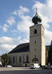
- Catholic parish church St. Veit an der Gölsen hl. Vitus
economy
In 2001 there were 117 non-agricultural workplaces, agricultural and forestry operations 185 according to the 1999 survey. According to the 2001 census, the number of people in employment at the place of residence was 1743. In 2001, the activity rate was 46 percent
Personalities
- Sons and daughters of the church
- Johann Fischer (1876–1954), politician (CSP), member of the Lower Austrian state parliament and member of the Federal Council
- Karl Kaiser (1941–2017), Austrian-Canadian winemaker
- Clemens Lashofer (1941–2009), former abbot of Göttweig Abbey
- Matthäus Nimmervoll (* 1950), emeritus abbot from Lilienfeld Abbey
Web links
- 31412 - St. Veit an der Gölsen. Community data, Statistics Austria .
- Market town of St. Veit on the Gölsen homepage of the municipality
Individual evidence
- ↑ The official spelling is specified or represented in the law on the division of the State of Lower Austria into municipalities, LGBl.No. 1030–94 of December 9, 2011 and on Statistics Austria: A look at the municipality
- ↑ Statistics Austria: Population on January 1st, 2020 by locality (area status on January 1st, 2020) , ( CSV )
- ^ Result of the local council election in 1995 in St. Veit an der Gölsen. Office of the Lower Austrian State Government, March 30, 2000, accessed October 10, 2019 .
- ^ Election result of the municipal council election 2000 in St. Veit an der Gölsen. Office of the Lower Austrian State Government, February 4, 2005, accessed October 10, 2019 .
- ^ Election result of the local council election 2005 in St. Veit an der Gölsen. Office of the Lower Austrian State Government, March 4, 2005, accessed October 10, 2019 .
- ^ Election result of the municipal council election 2010 in St. Veit an der Gölsen. Office of the Lower Austrian State Government, October 8, 2010, accessed October 10, 2019 .
- ^ Election result of the 2015 municipal council election in St. Veit an der Gölsen. Office of the Lower Austrian State Government, December 1, 2015, accessed on October 10, 2019 .
- ↑ Results of the municipal council election 2020 in St. Veit an der Gölsen. Office of the Lower Austrian State Government, January 26, 2020, accessed on February 6, 2020 .


