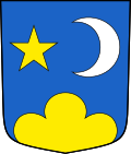
Gampel viola
| Gampel viola | |
|---|---|
| State : |
|
| Canton : |
|
| District : | Leuk |
| BFS no. : | 6118 |
| Postal code : | 3945 |
| Coordinates : | 623 213 / 129333 |
| Height : | 634 m above sea level M. |
| Height range : | 619–2768 m above sea level M. |
| Area : | 23.04 km² |
| Residents: | 1955 (December 31, 2018) |
| Population density : | 85 inhabitants per km² |
| Website: | www.gampel-bratsch.ch |
|
Viola |
|
| Location of the municipality | |
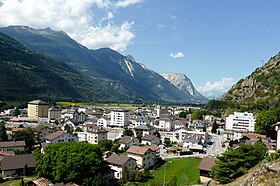
Gampel-Bratsch is a municipal and civic community in the Leuk district in the Swiss canton of Valais .
geography
The community is located in the upper German-speaking part of the Rhone Valley at the southern exit of the Lötschental valley . Gampel-Bratsch is the easternmost municipality in the Leuk district and borders the Lonza River .
The community consists of the villages of Gampel (with approx. 1300 inhabitants), Niedergampel (with approx. 450 inhabitants), Bratsch (with approx. 100 inhabitants) and the hamlets of Jeizinen and Engersch .
The municipal area covers an area of 2,310 hectares. Around 1,200 hectares are used for agriculture (arable farming, viticulture and pastureland), and around 550 hectares are forest (mainly pines, firs and larches). The remaining 550 hectares are unproductive (rock, steppe-like vegetation).
The municipality boundaries form the Rhone (German Rotten ) in the south, the Steigässi near Getwing in the west and the Nivengrad at 2,769 m above sea level in the north. In the east, the Lonza river forms the border from the mouth of the Rhone to the front Lötschental near Goppenstein . The neighboring communities are Steg-Hohtenn in the east, Turtmann-Unterems in the south, Leuk in the west and Ferden in the north .
history
Gampel-Bratsch was created on January 1st, 2009 from the merger of the two communities Gampel and Bratsch . The merger is based on a resolution passed by the voters of both communities on January 20, 2008.
population
| Population development | |||||||
|---|---|---|---|---|---|---|---|
| year | 2010 | 2011 | 2012 | 2013 | 2014 | 2015 | 2016 |
| Residents | 1909 | 1911 | 1921 | 1900 | 1908 | 1909 | 1965 |
Sights and culture
The Catholic Church of the Birth of Mary in Jeizinen, built in 1965, blends in well with the landscape despite its modern shape, also thanks to the roof pitch that is adapted to the houses in the area.
Gampel is especially famous for the Open Air Gampel , which takes place every year in August .
politics
Mayor is German Gruber (as of 2018). In addition to the mayor and vice-president, the council consists of five members. Twice a year there is an original assembly ( community assembly ).
Personalities
- Theophil Schnyder (1889–1959), Grand Councilor (1929–1945), Grand Council President (1939–1940)
- Daniel Hildbrand (1906–1992), Grand Councilor (1949–1969), Governor (1971–1976)
- Franz Hildbrand (* 1942), Grand Councilor (1973–1981), National Councilor (1987–1995)
- André Marty (* 1965), journalist
- Sina (* 1966), dialect rock singer
Parish partnership
literature
- Editor: Gampel-Bratsch. In: Historical Lexicon of Switzerland . 2016 .
- Rachel Siggen-Bruttin: Gampel. In: Historical Lexicon of Switzerland . 2017 .
- Gregor Zenhäusern: Viola. In: Historical Lexicon of Switzerland . 2017 .
Web links
Individual evidence
- ↑ Permanent and non-permanent resident population by year, canton, district, municipality, population type and gender (permanent resident population). In: bfs. admin.ch . Federal Statistical Office (FSO), August 31, 2019, accessed on December 22, 2019 .


