
Horw
| Horw | |
|---|---|
 |
|
| State : |
|
| Canton : |
|
| Constituency : | Lucerne Country |
| BFS no. : | 1058 |
| Postal code : | 6005 St. Niklausen 6047 Kastanienbaum 6048 Horw |
| Coordinates : | 666 336 / 207 658 |
| Height : | 441 m above sea level M. |
| Height range : | 433–1281 m above sea level M. |
| Area : | 12.86 km² |
| Residents: | 14,109 (December 31, 2018) |
| Population density : | 1097 inhabitants per km² |
|
Proportion of foreigners : (residents without citizenship ) |
17.1% (December 31, 2,015) |
| Website: | www.horw.ch |
 Horw |
|
| Location of the municipality | |
  |
|
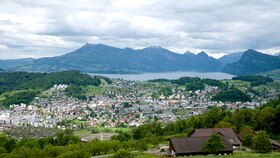
Horw (pronounced Horb [hɔrb] ) is a municipality in the Swiss canton of Lucerne . It is in the Lucerne-Land constituency .
geography
Horw is a southern suburb of the city of Lucerne and is located on Lake Lucerne at the foot of Mount Pilatus . Horw includes the Bireggwald (a high forest originally named after its birch trees ) in the northeast and the Horw peninsula in the east of the municipality, as well as the (alluvial) area west of the two and areas on the Pilatushang.
The rather large Bireggwald lies between the village and the south-eastern quarters of the city of Lucerne (including Matthof and Hirtenhof). To the north-west of it is the Biregg district, which politically belongs to Horw, but has grown together with the city of Lucerne.
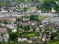
With the exception of the Dickiwald, the Horw peninsula has been almost completely cleared. There are numerous settlements on the shores of Lake Lucerne. The largest are the districts of St. Niklausen in the east and Kastanienbaum (with Villa Krämerstein ) in the southeast of the peninsula. In Felmis / Halt, south of the Bireggwald in the north of the peninsula, a large new district has been built in recent years.
The village of Horw with the parts Waldegg, Althof and Rank has grown and urbanized considerably in the second half of the 20th century and is traversed by several streams. To the southeast of the village, on the northwest corner of the peninsula, lies the Winkel an der Horwer Bucht. Winkel and - to the west of it - also located on the Horwer Bay district of Ennethorw have grown together with the village due to the brisk construction activity.
Ennethorw is at the foot of the Pilatus slope. This is largely forested and numerous streams flow through it. The largest are the Steinibach, which flows through Horw-Dorf and flows into Lake Lucerne in the delta in the Horw Bay, and the Wiedenbach, which flows into the lake on the west bank of the Horw Bay. The forest area that separates the communities of Horw and Hergiswil NW is called Haltiwald .
The lowest point of the municipality is the lake level of the Vierwaldstättersee at 434 m above sea level. M. The highest point of the municipality lies between Krienseregg and Fräkmünt at 1,281 m above sea level. M. im Hochwald (also called Upper Forest ).
The municipality covers an area of more than 20 km². Of this, however, only 1287 hectares are land. One third (32.4%) of this is used for agriculture. Around a quarter (24.1%) is settlement area. The Bireggwald and forests on the Pilatushang cover 42.4% of the community area.
Horw borders Lucerne in the north, Kriens in the west and Hergiswil NW (also called Hergiswil am See ) in the south . The Vierwaldstättersee forms a natural municipal boundary in the south and east.
population
The population grew rapidly from 1798 to 1837 (1798–1837: +52.9%), and then fell slightly by 1860. Another growth spurt followed between 1880 and 1910 (1880–1910: +74.8%). In the following decade, the population stagnated. After that there was an incessant increase in population until 1990. Shortly before 1970 the mark of 10,000 inhabitants was exceeded. From a statistical point of view, Horw has been a city ever since. In the decade from 1980 to 1990 there was a population standstill. This was again followed by a growth phase until 2013. Since then, the number of residents has fluctuated in a range from 13,800 to 13,900 people.

Sources: 1798–1837: Helvetic and cantonal censuses; Federal Office for statistics; 1850 to 2000 census results, 2010 ESPOP, since 2011 STATPOP
languages
The population uses a highly Alemannic dialect as their everyday language. In the last census in 2000, 86.47% said German, 2.32% Italian and 2.01% Serbo-Croatian as their main language.
Religions - denominations
The entire population used to be members of the Roman Catholic Church. This has changed as a result of leaving the church and immigration from other regions in Switzerland and abroad. The religious landscape looks today (as of 2000) as follows. There are 64.46% Roman Catholic, 15.06% Evangelical Reformed and 1.70% Orthodox Christians. In addition, we find 8.63% non-religious, 3.73% Muslim and 1.07% followers of other non-Christian religions. The majority of Muslims are Bosniaks and Albanians from Kosovo and Macedonia. There are also some Turks and Kurds. The majority of the followers of other non-Christian religions are Hindus of Tamil origin.
Origin - nationality
At the end of 2016, 11,483 of the 13,884 inhabitants were Swiss (82.71%) and 2,401 foreigners. At the end of 2016, the ten most important migration groups came from Germany (578 people; 4.16%), Italy (200 people; 1.44%), Kosovo (199 people; 1.43%), Portugal (166 people; 1.20%) ), Serbia (73 people; 0.53%), Eritrea (72 people; 0.52%), Spain (58 people; 0.42%), Great Britain (56 people; 0.40) and Austria (55 people; 0.40). At the end of 2015, a total of 17.3% of immigrants were of non-European origin.
history

The history of Horw's settlement is much longer than recorded in historical writings. Finds from prehistoric times (including the Stone Age and the Bronze Age ) were recovered in the municipality .
The first written mention of the place dates from 1231 ( bona nostra apud Horwe sita, our goods located near Horw). Horw is a secondary settlement name that goes back to a field name: Old High German horo, in the locative dative (ze) hor (o) we, means " swamp " or " moorland ". The community was part of the property of the Hofkloster zu Luzern. The name was first mentioned in the form of Horwe in 1231, when Walther von Hochdorf and his wife Berta bequeathed their property to the court monastery. In 1291 the Habsburgs became the new masters. After the battle of Sempach , the city of Lucerne took over the high jurisdiction in 1395, and in 1425 also the lower. Horw is obliged to pay a large sum of money because it faced the city of Lucerne in the Peasants' War in 1653 . At that time there was a skirmish at Winkel between the rebellious farmers and the troops of the city.
When Switzerland was conquered by the French in 1798, troops were billeted to subdue the rebellious Nidwalden. Up until this year Horw was administered as part of the Kriens Landvogtei. Until 1803 it belonged to the district of Lucerne, since then to the office of Lucerne . In the years 1844 and 1847, troops were again stationed in Horw (free troops and federal ones).
politics
Residential Council (Legislative)
The concerns of the population are represented by a residents' council. It consists of 30 members and is elected every four years by proportional representation. The L20 is an independent red-green list.
| Political party | 2020 | 2016 | 2012 | 2008 | 2004 | |
|---|---|---|---|---|---|---|
| L20 | 10 | 8th | 7th | 6th | 7th | |
| CVP | 7th | 9 | 9 | 9 | 11 | |
| FDP | 6th | 7th | 7th | 7th | 7th | |
| SVP | 5 | 6th | 7th | 8th | 5 | |
| glp | 2 | 0 | 0 | 0 | 0 |
Municipal Council (Executive)
The Horw municipal council consists of five members. All of them work in a part-time job (50–80%). The municipal councils are elected every four years by majority vote.
The five municipal councils for the 2016-2020 legislative period are:
- Ruedi Burkard (FDP): Mayor
- Thomas Zemp (CVP): Building Department
- Hans-Ruedi Jung (CVP): Finance Department
- Oskar Mathis (L20): Social Department (resigned on September 30, 2019)
- Robert Odermatt (SVP): Real Estate and Security Department (resigned on September 30, 2019)
- Claudia Röösli (L20): Social Department (since October 1, 2019)
- Jörg Stalder (L20): Real Estate and Security Department (since October 1, 2019)
Cantonal elections
In the 2019 Cantonal Council elections in the Canton of Lucerne, the voting shares in Horw were: CVP ( incl.JCVP ) 19.5%, Greens ( incl.JG ) 17.9%, SVP 17.5%, FDP 18.5%, SP (incl . Juso ) 13.7%, glp 10.0%, EVP 2.0%
National Council elections
In the 2019 Swiss parliamentary elections, the share of the vote in Horw was: SVP 22.3%, CVP 20.1%, FDP 17.1%, Greens 16.0%, SP 14.0%, glp 9.1%.
School & College
In Horw there are four primary school centers (Hofmatt, Kastanienbaum, Allmend and Spitz) and one school center for secondary level I.
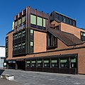
The Lucerne University of Applied Sciences and Arts is based in Horw . It is one of the five departments of the Lucerne University of Applied Sciences and Arts and offers courses in architecture, civil engineering (civil engineering), electrical engineering, building technology, IT, interior design, mechanical engineering and also industrial engineering / innovation. The school is very interdisciplinary and practical, so most of the students have previously completed an apprenticeship and a vocational baccalaureate.
The building technology department is unique in Switzerland. It is divided into three fields of study: heating-ventilation-air conditioning (HVAC), heating-sanitary (HS) and building electrical engineering (EE). Every year around 25 engineers from all over the country complete this training. Your professional future lies mainly in the planning and implementation of various building technology in the construction industry.
traffic
The community has excellent public transport connections. It is located on the Luzern - Interlaken (with S-Bahn line 5 Lucerne - Giswil), popularly known as Brünigbahn , and Lucerne - Stans - Engelberg (with S-Bahn line 4 from Lucerne to Wolfenschiessen) of the Zentralbahn and has the S-Bahn stops Horw and (since December 2004) Kriens-Mattenhof, which is located in the municipality of Kriens , but mainly opens up the Horw Brändiquartier. In addition to rail, there are various bus routes. The Biregg district in Lucerne, which is politically part of Horw, can be accessed by line 7 of the Lucerne trolleybus . It is operated by the Verkehrsbetriebe Luzern (VBL) and runs from the Biregghof via the Lucerne train station to the Wesemlin district. The quarters on the Horwer peninsula are integrated into the public transport network by bus line 21 (Kriens Zentrum-Pilatusmarkt-Horw Bahnhof-Kastanienbaum-St. Niklausen-Luzern Bahnhof). The main line is line 20 (Luzern Bahnhof-Horw-Ennethorw / Technikum). Since the timetable change in December 2013, bus line 14 has run from Horw Zentrum via the Pilatusmarkt shopping center, the Schlund industrial park in Kriens and along the eastern border from Kriens to Lucerne and on to the St. Anna Clinic (Lucerne) and the Würzenbach district in Lucerne. Line 16 connects the Spitz- and Rainliquartier in Horw via Horw Zentrum, the Pilatusmarkt, the Schlund industrial park and the Kuonimatt with the center of the neighboring municipality of Kriens.
Horw is on the main road Lucerne-Sarnen-Interlaken or Lucerne-Stans-Engelberg (common to Hergiswil NW). It has the Luzern-Horw motorway connection in the Schlund area on the A2 . For certain districts, the motorway connections Luzern-Kriens and Luzern-Zentrum - both also on the A2 - are important.
Others
Horw is one of the most tax-efficient municipalities in the Canton of Lucerne.
Attractions
photos

Horw seen from Pilatus

Horw seen from the Kirchfeldhügel
Horw, center

Horw, St. Katharina Church

Eawag chestnut tree

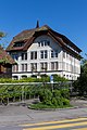
Farmhouse Oberdorni

University

Train station e.g.
Parish hall

reformed Church
Hofmatt schoolhouse

Allmend school building


Parish partnership
-
 Gampel-Bratsch , Valais (Switzerland)
Personalities
- Leonhard Haas (1833–1906), Roman Catholic bishop of Basel and Lugano
- Hans Aregger (* 1930 in Horw), folk musician and composer
- Paul Wolfisberg (1933–2020), football coach
- Michel Richter (* 1952), former radio presenter, TV journalist, copywriter, oldies DJ
- Philipp Hildebrand (* 1963 in Horw), former President of the Swiss National Bank
- DJ Bobo (* 1968), singer, dancer, composer and music producer, lives with his wife Nancy Baumann in Kastanienbaum
- Ronny Heer (* 1981), former Nordic combined athlete and member of SC Horw
- Ronny Hodel (* 1982 in Horw), football player
literature
- Waltraud Hörsch: Horw. In: Historical Lexicon of Switzerland .
- Barbara Hennig, André Meyer: The Art Monuments of the Canton of Lucerne, Volume II: The Office of Lucerne. The rural communities. Edited by the Society for Swiss Art History GSK. Bern 2009 (Art Monuments of Switzerland, Volume 116). ISBN 978-3-906131-90-0 . Pp. 152-194.
Web links
- Official website of the Horw community
- Community profile of the cantonal statistical office (PDF, 108 kB)
- Link catalog on Horw at curlie.org (formerly DMOZ )
Individual evidence
- ↑ Permanent and non-permanent resident population by year, canton, district, municipality, population type and gender (permanent resident population). In: bfs. admin.ch . Federal Statistical Office (FSO), August 31, 2019, accessed on December 22, 2019 .
- ↑ Permanent resident population according to nationality category, gender and municipality ( memento of the original from January 1, 2015 in the Internet Archive ) Info: The archive link was inserted automatically and has not yet been checked. Please check the original and archive link according to the instructions and then remove this notice. (Permanent resident population)
- ^ Linguistic Atlas of German-speaking Switzerland , Volume V 1b.
- ^ Alfred Helfenstein: The name of the Pilatus area. Keller & Co AG, Lucerne 1982, ISBN 3-85766-004-X , p. 31.
- ↑ Source: Robert Gubler, Population Development and Economic Changes in the Canton of Lucerne, Conclusion Table 1
- ↑ Balance of the permanent resident population according to demographic components, institutional structure, nationality and gender (Federal Statistical Office, STAT-TAB)
- ↑ LUSTAT: Community profile Horw ( Memento of the original from May 8, 2016 in the Internet Archive ) Info: The archive link was inserted automatically and has not yet been checked. Please check the original and archive link according to the instructions and then remove this notice.
- ↑ Lexicon of Swiss municipality names . Edited by the Center de Dialectologie of the University of Neuchâtel under the direction of Andres Kristol. Frauenfeld / Lausanne 2005, p. 455.
- ↑ Alfred Helfenstein: The Namengut Pilate territory. Keller, Luzern 1982, ISBN 3-85766-004-X , p. 47.
- ↑ LUSTAT Statistics Lucerne. Retrieved August 1, 2020 .
- ^ Federal Statistical Office : NR - Results parties (municipalities) (INT1). In: Federal Elections 2019 | opendata.swiss. August 8, 2019, accessed August 1, 2020 .