
Geology of Dresden


The majority of the rock near the surface in the urban area of Dresden are characterized by glacial deposits of the Pleistocene age. In the Elbe valley, fluvial deposits dominate , while in the area of the southern valley slope mostly aeolian sediments in the form of loess and loess loam occur. In the south and south-west these sediments are broken up by protrusions of the basement and transition storey. This is a diverse sequence of rocks of different formations and different ages, for example Cretaceous plans , Permian ( red-lying ) sedimentary rocks and volcanic rocks as well as Variscan intrusives . In the morphologically higher northern parts of the city, Proterozoic granitoids are also found near the surface.
The dominant tectonic element is the Lusatian fault (also known as the Lusatian thrust). It runs roughly parallel to the Elbe and characterizes the landscape of Dresden in a typical way.
Geography, morphology and topography
Morphologically, the area under consideration is characterized by the wide Elbe valley as well as the valley slopes, plateaus and mountain ranges adjoining it to the north and south.
Regional geological and structural characterization

The crystalline base belongs largely to the Saxothuringian on the northern edge of the Moldanubic (Bohemian Massif) and is part of the Western and Central European Variscides . From a regional geological perspective, the major part of the urban area is located in the sub-area of the Elbe zone. The Elbe zone is a striking, northwest-southeast running geological structural element characterized by thrusts or faults within the Variscides. The geological development of the Elbe zone results from an opposing tectonic movement of the Lausitz anticlinory and the Erzgebirge anticlinory in the Upper Carboniferous. In the observation area, it is bounded in the northwest by the Meißner massif, in the northeast by the Lusatian granodiorite complex and in the southeast by the marine sediments of the Saxon-Bohemian Chalk Depression. The oldest structural units in the Elbe zone are neoproterozoic graywacke and Cadomian granodiorite. The plutonites of the striking Meißner massif were intruded into the Neoproterozoic and Old Paleozoic rock sequences at the end of the Variscan mountain formation and were still affected by the decaying tectonic movements. The volcanic complex of Meißen-Priestewitz on top of it is the result of subsequent eruptive and effusive volcanism .
In summary, the Dresden city area is located in the area of or borders on the following structural units:
- The Lausitz granodiorite complex in the north and northeast (part of the Lausitz anticline zone)
- The Elbe Valley Slate Mountains in the southeast
- The eastern foothills of the Erzgebirge central zone in the south and southwest (part of the Fichtelgebirgisch-Erzgebirge anticline zone)
- The Döhlen Depression in the southwest and west
- The Meißner massif in the north and north-west
Other small-scale, island-like structures are also worth mentioning. The Weißig depression is located within the Lusatian granodiorite complex on the northeastern city limits . This is a locally limited remnant of the ceiling, which is formed from red-lying sedimentite-volcanite alternation and Cretaceous sedimentites. Another local structure is the Briesnitz Basin in the northwest of the city area. However, the red layer sequences of the Briesnitz Depression are not near the surface and are known from boreholes and underground outcrops.
Geological, tectonic and morphological development
The geological development of extra-alpine Central Europe was determined by general expansion tectonics following the Variscan orogeny since the early Permian. This was causally linked to the break-up of the great continent of Pangea and was significantly influenced in Central Europe by the opening movements of the western Thetys and later also of the Central and North Atlantic. The alpine mountain formation in southern Europe and in the alpine region also had a major impact on the tectonic development in central Europe: now the general crustal expansion stagnated and was replaced by compression and shear movements. However, tectonic disturbances resulting from these processes only began to affect the landscape in what is now Dresden since the Chalk. In the Upper Cretaceous, subsidence processes between the Lusatian and Central Saxon faults led to a trench-like subsidence in the area under consideration. With a simultaneous general rise in sea level, an arm of the Chalk Sea penetrated this subsidence structure from the southwest. This resulted in the accumulation of sediments of sandy facies to the east, which are typical of the Elbe Sandstone Mountains today. As the distance to the coast increased, a clay-marly facies , the so-called “ Pläner ”, settled further west between Pirna and Meißen . In today's urban area of Dresden, the planer breaks through the Quaternary cover, especially in the southern and southeastern urban area, and appears close to the surface as calcareous marlstone. After the end of the Cretaceous sedimentation, today's development of the Elbe Valley begins at the end of the Upper Cretaceous (caused by the opening of the North Atlantic) along the Lusatian Fault. The persistence of the tectonic movements in the Tertiary and especially in the Pleistocene led to further subsidence and enabled the Elster Cold Age inland ice to advance to the southeast. In the Holstein warm period , further erosive and denudative formation processes occurred with a subsidence of the Elbe valley. The right Elbe (northeastern) valley slopes were severely cut and formed steep-walled notch valleys (so-called "grounds") between the districts of Wachwitz and Pillnitz. To the left of the Elbe (southwest), the rivers in the Eastern Ore Mountains were included in these processes due to the regressive erosion and, in the lower reaches, diverted almost at right angles to the Elbe valley.
Tectonic elements

The tectonic structural elements that characterize the urban landscape are the Lusatian Fault (also Lusatian Thrust ) and the West Lusatian Fault. Both structural elements show a north-west-south-east (= herzyne ) strike direction and represent the north-east boundary of the Elbe zone to the Lusatian massif. The movement that originated from the Lausitz thrust and is detectable up to the present causes the older granodiorites of the Lausitz massif to morphologically higher level than the younger Cretaceous formations. The Weesenstein Fault, the Central Saxon Fault and the Karsdorf Fault run parallel to the Lusatian Thrust . In particular, the Central Saxon Fault can be seen as the south-western boundary of the Elbe zone in the area under consideration. It separates the Erzgebirge crystalline from the low-grade metamorphic foundation of the Elbe zone and shifts this as a right-lateral lateral shift by 80 to 90 kilometers to the southeast. Some transverse faults running at right angles to the main strike move the strata in the decameter range to northeast and southwest as well as vertically.
Floor division, stratigraphy and petrography
overview
The stratigraphic sequence of the geological subsurface of the urban area of Dresden can take place in clearly delimited floor units. The basis is formed by folded rock series of the Precambrian and the Paleozoic Era, which are subject to different metamorphic stresses and are heavily interspersed with plutonites and anatexites . Above it (especially in the area of the Döhlen Basin) molasse sediments of the transition storey with interposed tuffs and rhyolites of the younger Paleozoic Era follow. The greater part of the basement storey and part of the transition storey are predominantly concordantly overlaid by the overburden, which in the lying area consists of moderately solidified sediments of the (Upper) Chalk. The conclusion of the normal geological profile is formed by Pleistocene to Holocene deposits, which cover most of the central urban area.
Basement floor
The basement protrudes through the Pleistocene deposits of the overburden layer only in the southern and northeastern part of the urban area. In the north-east there are neoproterozoic granodiorites ( metatexites and anatexites ) of the Lusatian granodiorite complex. In the lying area of the sedimentary rocks of the Elbe valley, this unit is limited by the West Lusatian fault. To the southwest of this structural element, the Grauwacken of the neoproterozoic Weesensteiner group and the Cadomian Dohna granodiorite and old Paleozoic series of the Elbesyn Clinic together with monzonite intrusions from the Variscan Meißner massif form the subsoil. This is superficial in the Weißeritztal (Monzonit) and at the Gamighübel (Dohnaer Granodiorit).
Transition floor
The transition floor (also: Molasse floor ) of the Döhlener Senke occurs only in the extreme south-western part of the urban area. The sedimentation sequence extends from the Upper Carboniferous to the Upper Red Lying. Petrographically, it is clastic sediments ( silt and sandstones , conglomerates and arcoses ). This includes pyroclastics , mostly tuffs and rhyolites . In lower areas of the sequence, uranium-bearing coal also occurs.
Overburden floor
The Mesozoic part of the overburden floor consists of Upper Cretaceous deposits from the Elbe Depression. In the southwest, the cenomaniac sandstones , which are transgressively superposed on the transition or basement level, strike out. In the north-east they are overlaid by the plan of Turon to Coniac . The Lusatian thrust limits the spread of the Cretaceous sedimentary rocks in the northeast.
The majority of the urban area is covered by Quaternary unconsolidated rocks, the thickness of which varies between a few meters in the peripheral areas and approx. 25 m near the Elbe. In the Dresdner Heide there are even thicknesses of 70 m on the side of the Prießnitz valley . With the elevation of the Saxon low mountain range in the Tertiary , the rivers of the Elbe and its tributaries were formed. Climatic erosion and accumulation resulted in different terrace levels in the Lower and Middle Pleistocene. In the Middle Pleistocene, today's urban area was crossed by both ice advances from the Elster Glaciation and, in the northwest, probably also reached by ice from the older Saale stage. The Elbe has only flowed through the urban area since the later Lower Pleistocene. Up until the early Elster 2 stage, however, she used a valley that is now filled with younger sediments. The current course of the Elbe did not take place until the 2nd Elster ice advance. As a result, the old valley was buried and the present-day valley was excavated and erosively cleared. The sediments of the Elbe valley widening are thus dominated by Elster-2-Temporal to Holocene deposits of the Elbe and its tributaries. In the southern part of the urban area, ground moraines and meltwater formations occur, especially in the Elster 2 stage. In addition, there were periglacial deposits from the Vistula Ice Age in the form of loess and loess clay. To the north-east, sands (so-called “heather sand”) are mainly deposited by the Saale cold-age meltwater. In the Glacial Vistula, the dunes of the Dresdner Heide developed from this.
Floors
Soil development
During the Pleistocene, the advancing and retreating glaciers reshaped the topography in the viewing area. However, these periglacial processes also continued to have an impact in the low mountain range. Sandy, loamy or marl-like glacial, glacifluvial and / or fluvial sediments remained almost everywhere. The material eroded in the low mountain range was sedimented in so-called "gravel corridors". The finer grain fractions (clay, silt, fine sand) initially deposited in the sedimentation spectrum were mostly blown out by wind erosion and were deposited again in the southern part of the urban area. During the sedimentation process, fractionation was carried out depending on the wind speed. The loose masses created in this way were subject to gravitational compensation processes. In summer dew, the water-saturated layers on the frozen ground began to slide or flow . The result was an intensive mixing of the existing loose rock.
The youngest substrates can be found in the Elbe and the floodplains of its tributaries. There, alternating humus layers cover Pleistocene gravels, some of which were relocated in the Holocene and the formation of which can be traced back to flood events. The floodplain sediments received an above-average increase in thickness during the high medieval clearing phases in the low mountain range adjacent to the south. In the course of these periods there were intensive erosion processes on the predominantly unprotected forest soils with little vegetation. The resulting soil erosion was sedimented in the floodplains of the broad valleys.
It can be stated that the majority of the soil substrate present today was only created after the height of the Vistula cold period. Thus, the ancient Pleistocene to Early Holocene cover layers that arose under glacial or periglacial conditions are important for the soil inventory in the observation area. Their regional training fundamentally determines the spectrum of soil communities in the urban area and adjacent areas, which developed under relatively constant external conditions in the further course of the Holocene.
The originally very differentiated soil inventory has been largely anthropogenic over a large area due to the settlement activity that has continued since the Neolithic , combined with a recent increase in land use and intensification of land use.
Soil science conditions
Depending on the soil-forming factors and local substrate development, the individual soil shape is usually only very small. Characteristic soil associations, on the other hand, can be endured over a large area as soil form associations and leading soil associations. The delimitation is mainly based on lithogenetic features. In the nomenclature of soil research, a distinction is made between soil regions (BR), large soil landscapes (BGL) and soil landscapes (BL). The urban area is located in the area of the large soil landscape (BGL) of the "Loess Landscapes of the Bergland".
Depending on the geographic location, the following soil landscapes (BL) can be subdivided.
- Central area: Dresden Elbe valley expansion
- Northern and northeastern ridges: Lusatian loess hill country
- Southern slopes and plateaus: eastern continuation of the central Saxon loess region
- Eastern area: Eastern part of the Mulde-Loesshügelland
The following table provides a highly generalized overview of the above mentioned. Soil landscapes occurring leading soil associations and soil forms.
| Soil landscape | Leitbodengesellschaft | Soil shape |
| Elbe valley expansion | Area covered by recent floodplain dynamics |
|
| Area on low terrace sediments not (no longer) covered by current floodplain dynamics |
|
|
| Lusatian loess hill country | Substrates rich in skeletons resulting from the weathering of the base rocks |
|
| Loess-free, base-poor sandy soils ("Heidesandgebiet") |
|
|
| Southern slopes and plateaus | Soils made from loess and loess derivatives |
|
| Eastern area | mostly pseudo-gleyed soils made of loess and loess derivatives |
|
Hydrogeology
.
Meso- and Cenozoic unity


In the urban area of Dresden two hydraulically separated groundwater-bearing horizons (also: groundwater storeys ) can be distinguished. The lower (lying) horizon is formed by red-lying and Cretaceous sediments, the so-called "Cretaceous complex". In the northern outcrop area on the border with the Lusatian thrust, this unit reaches thicknesses of over 400 m. In the city center, the sediment thickness is 150 to 200 m. The depth exposure for groundwater extraction is limited to the upper 40 to 100 m. The groundwater occurs in the fine and medium-grain sandstones artesian taut.
It is worth mentioning a borehole sunk in 1837 in the Dresden-Neustadt district (on Albertplatz ), in which the chalk base reached 240 m and artesian water was tapped with an initial discharge of 8.5 l / s.
Little knowledge is available on groundwater dynamics. It can be assumed that the groundwater generally flows from the south (new formation area) to the north and relieves the pressure on the Lusatian thrust into the hanging Quaternary.
There is currently no drinking water pumping from the lying aquifer. Due to its protection, this groundwater is kept as a strategic reserve.
Quaternary unit
The upper ( hanging ) groundwater horizon is made up of Pleistocene sands and gravels and is essentially only formed in the immediate Elbe valley. The permeable layers are partially covered by low-permeability areas. The main aquifer is limited in the north by the Lausitz thrust and in the south by the high elevations of the Cretaceous marl . The general direction of groundwater flow is towards the main receiving river, i.e. towards the Elbe. When the Elbe floods, the groundwater flow direction can be reversed, so that river water flows into the subsoil. Likewise, anthropogenic interventions in the subsoil, for example through dewatering and groundwater extraction, can lead to changes in the natural groundwater flow regime.
In Dresden, groundwater is obtained from numerous individual wells and well galleries to provide drinking and service water. The daily flow rate is currently approx. 22,000 m³.
The groundwater level is monitored in the city with numerous automatic measuring points.
Engineering geology

overview
NOTE: The following statements on the engineering geological conditions in the urban area of Dresden are merely informative and generally valid. They are not a substitute for a subsoil and / or geotechnical expertise for a possible construction site.
In the following engineering-geological description of the geological units occurring in the area under consideration, a distinction is made between loose and solid rock , each of which can be combined into groups with similar structural properties. The classification criterion for solid rock is weathering resistance , while the loose rock is classified into groups with a similar grain size composition according to DIN 18196 .
Solid rock
Weather-resistant rock types
The two-mica and biotite granodiorites , monzonites , andesites and greywackes of the basement level, which occur in the urban area and are present in the usual building-practical depth range , have a high rock strength. In their areas of distribution they therefore form steep slopes in valleys. These rocks are frost-proof for foundations and are also suitable for large loads. To take into account is usually a strong division to foliation surfaces and crevices , which may occur in the area of steep slopes, especially in freeze thaw resistance phases landslides and terrain breaks. The rock types mentioned are moderate in their weathered zone and difficult to remove in the unweathered state ( soil class 6 - 7).
Slightly weather-resistant rock types
This group includes, for example, tuff , tuffite and slate of the transition floor as well as marl, clay and silt stones of the transition floor. It is a matter of frost-changeable rocks, which have a medium strength in the unweathered state and which decreases sharply with increasing degree of weathering. The marl, clay and silt stones weather due to porosity and water absorption capacity to form stiff to semi-solid clay. The depth of weathering can be over 5 m. Due to their interface structure and the material properties, only medium loads can be applied to these types of rock. Higher structural loads must be compensated for by means of constructive measures, i.e. suitable foundation types and adequate foundation dimensions.
Loose rock
Organic soils
Organic soils occur within Aue and Tallehm in the range of silted Altwasserläufen on. Because of their strong sensitivity to frost and virtually non-existent load capacity, these soils are unsuitable as building and need to viable material exchanged are.
Fine-grained soils
These soil types are divided into two further subgroups with regard to their formation: fluvial and aeolian formations. The first-mentioned category includes alluvial and valley loams, which occur in the form of clayey, sandy to very sandy silt with light to medium plasticity and usually with a soft to stiff consistency . Due to the high compressibility, the load-bearing capacity is low to moderate, which must be taken into account when selecting the foundation and foundation structure. It should also be noted that fine-grained soils tend to lose consistency under the influence of groundwater and surface water, which further reduces the load-bearing capacity. In morphologically higher areas of the urban area, aeolian formations in the form of loess and loess loam occur increasingly . Pure loess rarely occurs near the surface. It is found in the form of calcareous, non-stratified, slightly platy silt beneath loess loam coverings. The loess loam, which occurs in the usual building depths, is mostly medium-plastic, clayey silt, which, with at least a stiff consistency, is conditionally suitable as a subsoil, depending on the load input.
Mixed-grain soils
Mixed-grain soils are divided into cohesive and non-cohesive soils according to the property-determining fine-grain fraction according to DIN 1054 ( Eurocode 7, DIN EN 1997-1) , which i. d. As a rule, it can only be conclusively carried out as a result of soil physical investigations on soil samples.
Glaciated formations
The boulder clay found in the south of the urban area is a silty, clayey sand that occasionally also contains gravel and stones. Both the composition and the consistency can differ horizontally and vertically, so that settlement differences must be taken into account when applying structural loads. A locally limited water flow within coarse-grained layer inclusions ("lenses") must also be observed. In general, the boulder clay has a medium to good load-bearing capacity. Due to the high proportion of fine grains, however, the boulder clay is sensitive to weathering and tends to lose consistency when water is absorbed.
Autochthonous weathering soils
Weathered products of the solid rock (granodiorite of the Lusatian massif, metamorphic rocks of the Elbe zone) are formed close to the surface and depending on the degree of weathering as weathered clay (clayey silty to very silty sand). With the depth there is a transition to weathered debris (silty, sandy gravel, partly with stones). The upper cohesive weathering horizon has a moderate bearing capacity, which can decrease further under the influence of water. The weathering debris is usually good bearing.
Solifluid and periglacial deposits
This floor category includes hanging ceilings and so-called "moving rubble ceilings". With regard to the grain size composition, they are similar to the weathering formations. Coarse-clastic parts are rounded, and there is often adjustment in the area of the foot of the slope. The debris cover is often covered by slope loam and solifluction loess. Slope rubble is generally good load-bearing, depending on the grain size composition, the compaction ability may be limited. In periods of heavy rainfall, weathered debris and hillside debris can temporarily lead to stratified water.
Coarse-grained soils
The group of coarse-grained soils includes fluvial and glacifluvial sands and gravels as well as Aeolian fine and medium sands. These different geneses result in different material properties, which require a further subdivision. Overall, coarse-grained soils are resistant to frost and weather and have good bearing capacity.
Fluvial sands and gravels
With a few exceptions (narrowly graduated Early Weichselian sediments of the Elbe and Prießnitz ), the fluvial sands and gravels show similarities with the non-cohesive mixed- grain soils. They have good to very good load-bearing capacity and compressibility.
Dune and meltwater sands (Heidesand)
These types of soil are difficult to distinguish lithologically . It is a narrowly graded medium-sized sand with small proportions of fine and medium sand with fine-grain proportions below 5% with good load-bearing properties. However, due to the dominance of the medium-sand grain fraction, there is poor compressibility. In addition, tightly stepped sands tend to displace the grain (flow out) when dynamically stimulated.
Soil properties for loose rock
For soil mechanical considerations, foundation measurements, etc. the values listed in the table below can be roughly applied.
| Soil type | Floor pan | Soil class (solvability) |
Weight cal γ kN / m³ |
Weight u. Buoyancy cal γ´ kN / m³ |
Friction angle cal φ´ degrees (°) |
Cohesion cal c´ kN / m² |
Permeability k f m / s |
Frost class |
|---|---|---|---|---|---|---|---|---|
| mixed-grain soils | SU *, ST *, GU *, GT *, TL | 3 - 4 | 20th | 10 | 27 | 1 | 10 −5 - 10 −7 | F 2 - F 3 |
| coarse-grained soils (narrowly graduated) | GI, GE, GT, SI, SE, ST, GU, SU | 3 | 19th | 11 | 31 | 0 | 10 -3 - 10 -5 | F 1 |
| coarse-grained soils (widely graded) | GW, SW, GU, SU | 3 | 19th | 11 | 34 | 0 | 10 −2 - 10 −3 | F 1 |
| fine-grained soils | TL, TM, UL, UM, GT *, ST *, SU *, GU * | 4 - 5 | 20th | 10 | 22nd | 10 | 10 −6 - 10 −8 | F 3 |
Old mining
Old mine workings are located in the south-western part of the Gittersee district and belong to the eastern part of the Freital-Burgk mining area . Here, hard coal has been extracted from the Rotliegend sediment in the Döhlen depression since the 16th century . Since the coal contained uranium, Wismut AG / SDAG mined from 1945 to 1989 . The water in the area was loosened by the Tiefen Elbstollen which was built in the 19th century and which still drains the mine buildings today. In the old mining area, day breaks and subsidence must be expected, which must be included in the planning of construction projects.
Earthquake hazard
According to DIN 4149 , Dresden is not in the area of relevant earthquake hazard. It is pointed out, however, that the fading tectonic movements of the Egertalgraben trigger slight tremors that can be perceived as far as the Dresden area.
Raw materials and raw material extraction

Igneous and sedimentary solid rock as well as quaternary deposits form a geological raw material potential for the extraction of stones and earth. In the past, building materials were extracted from a large number of sand, gravel and clay pits. Quarries mainly supplied masonry stones. These are, for example, sandstones from the Oberhäslicher layers, plans and limestone from the base of the Strehlen layers. At present, the Pleistocene sands on the Hellerberg Mountains in the northern part of the city are primarily extracted as building raw materials.
Use of solid rock
In the southwestern part of the valley slopes of the Weißeritztal, the monzonite of the Meißner massif is exposed over a large area. In the stone quarries of the Plauenschen Grund , this rock was extracted over a long period of time for the production of gravel and chippings, for wall and paving stones and as material for packing stores. From 1963 to 1970 only the council quarry in Dölzschen and the “Heidenschanze” quarry in Coschütz were in operation. A total of up to 70,000 t of raw material for concrete aggregates and road construction material was extracted annually. The rocks of the Lusatian granodiorite complex that occur in the northeastern area were used for stone extraction in past centuries, as a number of old quarries testify to. Today the granodiorites are excluded from the use of raw materials for reasons of landscape and nature conservation.
Sand and gravel
Sands of the hall glacial meltwater formations
This sand pouring is common in the north and northeast. It is made up of fine to medium-sized sand with a narrow layer and in the area of the Hellerberg mountains reach a thickness of up to 60 m. They are suitable for the production of sand-lime bricks and as masonry, plaster and mortar sands. In the past, mining took place in the sand pits on Hammerweg and Proschhübelstraße in the north. Sand pits east of the Prießnitzgrund and on Augustusweg are currently in operation. The latter deposit contains a supply of approx. 100 million tons and forms the raw material basis for a sand-lime brick plant and the supply of the urban area with building materials. The meltwater sands are of high quality even as unprocessed conveyed goods: a high degree of homogeneity, a quartz content> 90% and a small amount of fine and gravel grains.
Glazy sands and gravels

Sands and gravels from the Elster, Saale and Vistula Ice Ages are extensively available in the urban area. Mining took place in the southeast ( Dobritz and Leuben ) and in the northwest ( Kaditz ). The usable thicknesses are up to 15 m with simple and undisturbed storage conditions. The wear layers are divided into an upper sandy deposit part (<20% gravel) and a lower gravel part (> 50% gravel). Degradation takes place in dry and wet cutting. Former gravel quarries are used as bathing water in the urban area.
Brick clay

Loess, loess loam and slope loam are found on the southeastern slope of the Elbe valley in thicknesses of up to 10 m. Together with the plan marls of the Räcknitzer layers occurring at the deposit base, there was not only a good raw material quality but also a favorable supply situation. Primarily solid and vertically perforated bricks were produced. From 1994 the mining of brick clay was stopped for economic reasons and the Waschneck brickworks closed. Occasionally, clay has been extracted since then for use as sealing material, for example to cover and secure old landfills. After obtaining a permit under mining law since 2016, Ziegelwerk Freital EDER GmbH opened a new opencast mine with a volume of 1.65 million cubic meters of raw material on an area of 22.5 hectares south of Dohnaer Strasse.
Outcrops
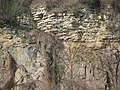
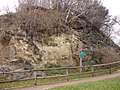
Ratssteinbruch in Plauenschen Grund , Pläner (Elbe-Senke) discordant over Monzonite (Meißner Massif)

The council quarry around 1930

Pläner rock sample with typical staining from the council quarry

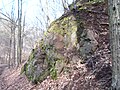
Granodiort quarry at the Mordgrundbrücke (Lusatian granodiorite complex)

Monzonite in the Plauenschen Grund (Meißner Massif)

Monzonite in the Plauenschen Grund (Meißner Massif), via ferrata below the Beegerburg
Monzonite in the Tännichtgrund near Niederwartha (Meißner massif)

Monzonite in the Tännichtgrund, fresh cut after flooding

Prießnitz waterfall in the Dresdner Heide, granodiorite (Lusatian granodiorite complex)

Porphyrite quarry on Hutberg near Weißig (Weißiger Senke within the Lusatian granodiorite complex)

Pleistocene heather sand on a slope of the Prießnitz in the Dresdner Heide

Cutting of granodiorite gneiss (Großenhainer gneiss complex) on a slope of the Prießnitz in the Dresdner Heide
“Hoher Stein” in the Plauen district, Monzonite cliff with pockets of surf from the marine cenomans


literature
Written material
- W. Alexowsky, JW Schneider and others: Explanations of the geological map of the Free State of Saxony 1: 25,000. Sheet 4948 Dresden, Saxon State Office for Environment, Geology and Agriculture, Freiberg 2001.
- H.-D. Beeger, W. Quellmalz: Geological guide through the area around Dresden. Verlag Theodor Steinkopf, Dresden / Leipzig 1965. (revised edition: Gebrüder Bornträger, Berlin / Stuttgart 1994, ISBN 3-443-15062-4 )
- D. Henningsen, G. Katzung: Introduction to the geology of Germany. Elsevier Spectrum Academic Publishing House, 2006, ISBN 3-8274-1586-1 .
- H.-P. Jordan, H.-J. Neither (Ed.): Hydrogeology - Fundamentals and Methods. Reg. Hydrogeology: MV, BB, B, SAH, SX, TH, Ferdinand Enke Verlag, Stuttgart 1995.
- H. Murawski, W. Meyer: Geological dictionary. Spektrum Akademischer Verlag, Heidelberg 2010, ISBN 978-3-8274-1445-8 .
- J.-M. Lange, N. Janetschke, M. Kaden, M. Preusse: Landscape development in the vicinity of Dresden - sedimentation, volcanism and tectonics in the Cenozoic. In: Annual reports and communications from the Upper Rhine Geological Association. Volume 97, 2015, pp. 69-102.
- U. Linnemann (Ed.): Geologica Saxonica, Das Saxothuringikum - Outline of the Precambrian and Paleozoic geology of Saxony and Thuringia. In: Abh. State Museum of Mineralogy and Geology. Dresden 2004, ISBN 3-910006-27-2 .
- K. Mannsfeld, R.-U. Syrbe (Ed.): Natural spaces in Saxony. (= Research on German regional studies. Volume 257). German Academy for Regional Studies Leipzig eV 2008, ISBN 978-3-88143-078-4 .
- WR Nessig : Geological excursions in the area around Dresden. In: Annual report of the Dreikönigsschule Dresden-Neustadt 1897 and 1898; extended, with 2 plates, Dresden 1898 ( Digitalisat the slub Dresden ).
- W. Pälchen, H. Walther (Hrsg.): Geology of Saxony - Geological structure and history of development. E. Schweitzerbart'sche Verlagbuchhandlung (Nägele and Obermiller), Stuttgart 2008, ISBN 978-3-510-65239-6 .
- K. Pietzsch: Outline of the geology of Saxony. Volk und Wissen publishing house, Berlin 1951.
- O. Wagenbreth, W. Steiner: Geological forays - landscape and geological history between Cape Arkona and Fichtelberg. VEB German publishing house for basic industry, Leipzig 1982.
- R. Walter: Geology of Central Europe. E. Schweitzerbart'sche Verlagbuchhandlung (Nägele and Obermiller), Stuttgart 2007, ISBN 978-3-510-65225-9 .
cards
- Geological overview map of the Federal Republic of Germany 1: 200,000. Sheet CC 5542 Dresden, Ed .: Federal Agency for Raw Materials, Hanover 2001
- Geological map of the Free State of Saxony 1: 25,000. Saxon State Office for Environment, Geology and Agriculture, Freiberg 2001
- Geological overview map of the Free State of Saxony 1: 400,000. Saxon State Office for Environment and Geology 1995
- Geological map of the areas of Saxony covered by the Ice Age 1: 50,000. Sheet 2668 Dresden, Saxon State Office for Environment and Geology 1994
- Overview map of the soils of the Free State of Saxony 1: 400,000. Saxon State Office for Environment and Geology 1993
- Hydrogeological map of the GDR 1: 50,000. Sheet 1209-3 / 4 Dresden, Central Geological Institute of the GDR, Berlin 1983–1986
- Quaternary lithofacies map, scale 1: 50,000. Sheet 2668 Dresden, Central Geological Institute of the GDR, Berlin 1974
- Geological map of the ČSSR, scale 1: 200,000. Sheet M-33-VIII Chabařovice-Dresden, Geological Service of the ČSSR, Prague 1964
- Special geological map of the Kingdom of Saxony, scale 1: 25,000. Section Pillnitz-Weißig, sheet no. 67 (new 4949), reprint of the original edition 1907/1908, Staatsbetrieb Geobasisinformation und Vermessung Sachsen
- Special geological map of the Kingdom of Saxony, scale 1: 25,000. Moritzburg-Klotzsche section, sheet no. 50 (new 4848), reprint of the original 1907 edition, Staatsbetrieb Geobasisinformation und Vermessung Sachsen
Other media
- D. Franke: Regional geology of East Germany - A dictionary. Parchim 2017 (collection of PDF documents, see also web links) [Franke 2017]
Individual evidence
- ↑ U. Linnemann (Ed.): Geologica Saxonica, Das Saxothuringikum - Outline of the Precambrian and Paleozoic geology of Saxony and Thuringia. 2004, p. 19 ff.
- ↑ D. Henningsen, G. Katzung: Introduction to the geology of Germany. 2006, p. 73.
- ↑ U. Linnemann (Ed.): Geologica Saxonica, Das Saxothuringikum - Outline of the Precambrian and Paleozoic geology of Saxony and Thuringia. 2004, p. 147 ff.
- ↑ J.-M. Lange, N. Janetschke, M. Kaden, M. Preusse: Landscape development in the area of Dresden. 2015, pp. 3–5.
- ↑ Lithofazieskarte Quaternary, scale 1: 50,000. Sheet 2668 Dresden, Central Geological Institute of the GDR, Berlin 1974.
- ↑ W. Pälchen, H. Walther (Ed.): Geology of Saxony - Geological construction and development history. 2008, p. 253.
- ↑ a b R. Walter: Geology of Central Europe. 2007, p. 285 ff.
- ↑ W. Pälchen, H. Walther (Ed.): Geology of Saxony - Geological construction and development history. 2008, pp. 28, 78, 164, 240, 275, 314, 419 ff.
- ↑ W. Alexowsky, JW Schneider et al.: Explanations of the geological map of the Free State of Saxony 1: 25,000. Sheet 4948 Dresden, 2001, p. 64 ff.
- ↑ W. Alexowsky, JW Schneider et al.: Explanations of the geological map of the Free State of Saxony 1: 25,000. Sheet 4948 Dresden, 2001, p. 8.
- ↑ a b W. Alexowsky, JW Schneider et al: Notes on the Geological Map of Saxony 1: 25.000. Sheet 4948 Dresden, 2001, pp. 7–9.
- ↑ W. Pälchen, H. Walther (Ed.): Geology of Saxony - Geological construction and development history. 2008, pp. 28, 48, 79, 98.
- ↑ W. Pälchen, H. Walther (Ed.): Geology of Saxony - Geological construction and development history. 2008, pp. 240-253, 275 ff.
- ↑ W. Pälchen, H. Walther (Ed.): Geology of Saxony - Geological construction and development history. 2008, pp. 311-330, 419 ff.
- ↑ W. Alexowsky, JW Schneider et al.: Explanations of the geological map of the Free State of Saxony 1: 25,000. Sheet 4948 Dresden, 2001, pp. 64–91.
- ↑ W. Pälchen, H. Walther (Ed.): Geology of Saxony - Geological construction and development history. 2008, pp. 462-463.
- ↑ W. Alexowsky, JW Schneider et al.: Explanations of the geological map of the Free State of Saxony 1: 25,000. Sheet 4948 Dresden, 2001, p. 131.
- ^ Hydrogeological map of the GDR 1: 50,000. Sheet 1209-3 / 4 Dresden, Central Geological Institute of the GDR, Berlin 1983–1986
- ^ Groundwater environmental report. State capital Dresden, Environment Agency, 2016.
- ↑ K. Huhle: Hydrogeological conditions. In: Alexowski et al.: Explanations of the geological map of the Free State of Saxony. 1: 25,000 s. O.
- ↑ W. Alexowsky, JW Schneider et al.: Explanations of the geological map of the Free State of Saxony 1: 25,000. Sheet 4948 Dresden, 2001, pp. 125–130.
- ↑ a b DIN 18196, Earthworks and Foundation Works - Soil Classification for Structural Purposes, Draft 2004.
- ↑ DIN 18300, VOB procurement and contract regulations for construction works, Part C: General technical contract conditions for construction works (ATV) - earthworks, 2002
- ↑ a b c d DIN 1054, subsoil - proof of safety in earthworks and foundation engineering, 2005
- ↑ DIN 18130 - Subsoil, investigation of soil samples: Determination of the water permeability coefficient, 2003
- ↑ ZTVE-StB 94: Additional technical contract conditions for earthworks in road construction (version 1997)
- ↑ DIN 4149, Buildings in German Earthquake Areas - Load Assumptions, Dimensioning and Execution of Common Buildings, 2005.
- ↑ The earthquake in the Czech Republic makes houses shake in Saxony . In: Sächsische Zeitung , May 31, 2014.
- ↑ W. Alexowsky, JW Schneider et al.: Explanations of the geological map of the Free State of Saxony 1: 25,000. Sheet 4948 Dresden, 2001, pp. 114–116.
- ↑ Nora Domschke: Eder brickworks gets clay from Dresden. In: Sächsische Zeitung v. 10/11 June 2017, p. 8
Web links
- Saxon State Office for Environment, Geology and Agriculture
- Saxon State and University Library, German Photo Library
- State enterprise geobase information and surveying Saxony
- State Natural History Collections Dresden, Museum of Mineralogy and Geology
- State capital Dresden, themed city map
- www.regionalgeologie-ost.de