Gross Ellingen
|
Gross Ellingen
Hohenberg-Krusemark municipality
Coordinates: 52 ° 42 ′ 18 ″ N , 11 ° 57 ′ 44 ″ E
|
||
|---|---|---|
| Height : | 36 m above sea level NHN | |
| Area : | 8.29 km² | |
| Residents : | 123 (Jan 2020) | |
| Population density : | 15 inhabitants / km² | |
| Incorporation : | July 1, 1950 | |
| Incorporated into: | Ellingen | |
| Postal code : | 39596 | |
| Area code : | 039394 | |
|
Location in Saxony-Anhalt |
||
|
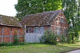
Listed farm at Heerstraße 14
|
||
Groß Ellingen is a district of the community Hohenberg-Krusemark in the district of Stendal , Saxony-Anhalt .
geography
Groß Ellingen, a street village , is located about 2 kilometers southeast of Hohenberg-Krusemark and 15 kilometers southeast of Osterburg (Altmark) , and about 4 kilometers west of the Elbe in the Altmark .
The same bike path leads from Arneburg coming through the village on a bike path to Krusemark north.
Neighboring towns are Altenau in the west, Krusemark and Hohenberg in the northwest, Klein Ellingen in the northeast and Beelitz in the south.
Subdivision breakdown
In addition to the village of Groß Ellingen, the district consists of the residential areas Altenau and Burckhardshof .
history
The first mention of the place dates back to 1320 as Magna Ellinge when the Duchess Anna the Monastery Arendsee revenue from two yards vereignete. Further mentions are 1343 to groten ellingen , 1687 Grossen Ellingen and 1804 Dorf and Gut Groß Ellingen .
First mentioned in 1289
The historian Peter P. Rohrlach points out that the first mention of Wilhelm Zahn in 1289 as ellinge cannot be proven. Zahn stated that Groß Ellingen was the ancestral home of the "von Ellinge" family, who had lived in the Uckermark since 1286. What is probably meant is the Prenzlauer district Ellingen .
Desert near Groß Ellingen
In 1909, Wilhelm Zahn assumed that Vinzlow was deserted near Groß Ellingen. He described their location as follows: 1.25 kilometers east of the village is the wooded hill "Rietzenberg" on the west side of which is the wooded terrain "Büschlings-Ellingen", to which the "Wendish church clap" adjoins to the southwest. Since "formerly 6 paths converged there, a village must have been here". The field names mentioned by Zahn are no longer in use today.
Incorporations
On July 1, 1950, the communities Groß Ellingen and Klein Ellingen from the district of Osterburg merged to form the community Ellingen. The two former communities became districts. On February 1, 1974, the community of Ellingen was incorporated into Hohenberg-Krusemark. This brought the two districts to the community of Hohenberg-Krusemark.
Population development
|
|
|
|
|
Source if not stated:
religion
The Protestant Christians from Groß Ellingen used to belong to the parish of Krusemark. Today they belong to the parish Krusemark-Goldbeck and are looked after by the parish of Klein Schwechten of the parish of Stendal in the Provostspengel Stendal-Magdeburg of the Evangelical Church in Central Germany .
Culture and sights
- A farm and a farmhouse are under monument protection.
literature
- Peter P. Rohrlach: Historical local lexicon for the Altmark (Historical local lexicon for Brandenburg, Part XII) . Berliner Wissenschafts-Verlag, Berlin 2018, ISBN 978-3-8305-2235-5 , pp. 609-613 .
- Wilhelm Zahn : Local history of the Altmark . Edited by Martin Ehlies based on the bequests of the author. 2nd Edition. Verlag Salzwedeler Wochenblatt, Graphische Anstalt, GmbH, Salzwedel 1928, DNB 578458357 , p. 166 .
- JAF Hermes, MJ Weigelt: Historical-geographical-statistical-topographical handbook from the administrative districts of Magdeburg . Topographical part. Ed .: Verlag Heinrichshofen. tape 2 , 1842, p. 368 , 33. Groß-Ellingen ( digitized version ).
Web links
- Hohenberg-Krusemark on arneburg-goldbeck.de.
- Groß Ellingen in the historical directory of the association for computer genealogy
Individual evidence
- ↑ a b c d Peter P. Rohrlach: Historical local lexicon for the Altmark (Historical local lexicon for Brandenburg, Part XII) . Berliner Wissenschafts-Verlag, Berlin 2018, ISBN 978-3-8305-2235-5 , pp. 609-613 .
- ↑ a b Ingo Gutsche: Joy of many new arrivals . (As of January 2020). In: Volksstimme Stendal . January 18, 2020.
- ↑ a b Directory of municipalities and parts of municipalities . Area as of 1 April 2013 (= Statistical Office Saxony-Anhalt [Ed.]: Directories / 003 . No. 2013 ). Halle (Saale) May 2013, p. 114 ( destatis.de [PDF; 1.6 MB ; accessed on August 24, 2019]).
- ↑ a b Saxony-Anhalt viewer of the State Office for Surveying and Geoinformation ( notes )
- ^ Adolph Friedrich Riedel : Codex diplomaticus Brandenburgensis : Collection of documents, chronicles and other source documents . Main part 1st volume 22 . Berlin 1862, p. 26 ( digitized version ).
- ^ Friedrich Wilhelm August Bratring : Statistical-topographical description of the entire Mark Brandenburg . For statisticians, businessmen, especially for camera operators. tape 1 . Berlin 1804, p. 293 ( digitized version ).
- ^ A b c d e Wilhelm Zahn : Heimatkunde der Altmark . Edited by Martin Ehlies based on the bequests of the author. 2nd Edition. Verlag Salzwedeler Wochenblatt, Graphische Anstalt, GmbH, Salzwedel 1928, DNB 578458357 , p. 166 .
- ^ Adolph Friedrich Riedel : Codex diplomaticus Brandenburgensis : Collection of documents, chronicles and other source documents . Main part 1st volume 21 . Berlin 1861, p. 4 ( digitized version ).
- ^ Wilhelm Zahn : The desolation of the Altmark . In: Historical sources of the Province of Saxony and neighboring areas . tape 43 . Hendel, Halle as 1909, p. 314 , no. 151 .
- ↑ Federal Statistical Office (Ed.): Municipalities 1994 and their changes since 01.01.1948 in the new federal states . Metzler-Poeschel, Stuttgart 1995, ISBN 3-8246-0321-7 , pp. 343, 345 .
- ^ A b Doreen Schulze: For the first time growth in Arneburg-Goldbeck . In: Volksstimme Stendal . 15th January 2016.
- ↑ a b Karina Hoppe: Verbandsgemeinde Arneburg-Goldbeck lost a total of 93 inhabitants in 2018 . In: Volksstimme Stendal . February 14, 2019.
- ↑ Parish Almanac or the Protestant clergy and churches of the Province of Saxony in the counties of Wernigerode, Rossla and Stolberg . 19th year, 1903, ZDB -ID 551010-7 , p. 125 ( wiki-de.genealogy.net [accessed February 22, 2020]).
- ^ Parish area Klein Schwechten. Retrieved February 22, 2020 .


